
BooneWX
-
Posts
1,320 -
Joined
-
Last visited
Content Type
Profiles
Blogs
Forums
American Weather
Media Demo
Store
Gallery
Posts posted by BooneWX
-
-
1 hour ago, Met1985 said:
Models are modeling. All ill say is the the ensembles are still looking good. The cold air will be around we just need things to match up. Just be patient. We are fixing to enter into much better climo snow wise.
I agree. I don’t see any reason to think anything has been canceled or delayed. With a pattern change this stout and the teleconnections on the table, it’s wise to take the average of the models instead of falling for the back and forth of the Ops.
-
 2
2
-
-
Maybe I missed something but both the EPS and GEFS looked perfectly fine. If anything, it was a positive trend since the prior ensembles had the type of cold that’ll send the lows into Cuba.
-
4
-
-
Just now, eyewall said:

I’ll take 33 and rain instead of that.
-
Deep breaths folks. The ingredients are on the table. Just gotta hope Russell Wilson ain’t the chef.
-
1
-
-
That 18/19th timeframe just continues to look interesting.
-
2
-
-
1 minute ago, Met1985 said:
This is like a broken record but again the GEFS does not agree with the OP. It blasts the front through here and the majority of us get cold.
the OP has been on such a wild ride these past few days. It was still painting phantom hurricanes in the Atlantic just a few days ago.
-
1
-
-
Man oh man this pattern is going to favor some seriously frequent flow events.
-
4
-
-
1 hour ago, mclean02 said:
I spy some eye candy finally could we have white (Sleet) Christmas in the Triad??
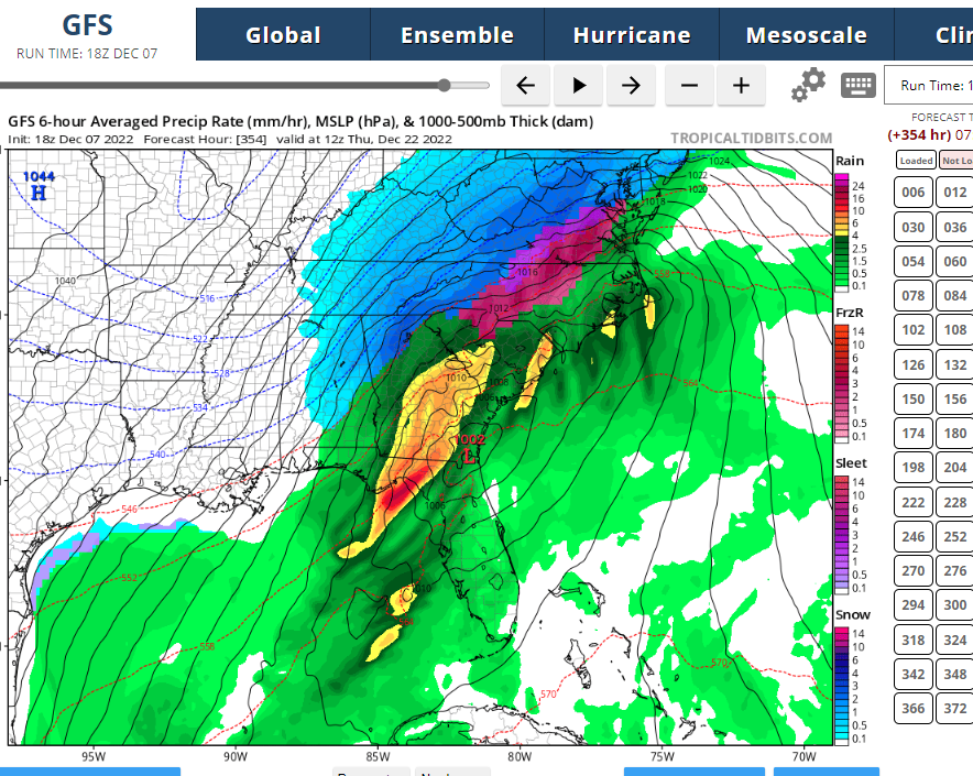
Incredible that even the new GFS knows where I-85 is
-
1
-
 3
3
-
-
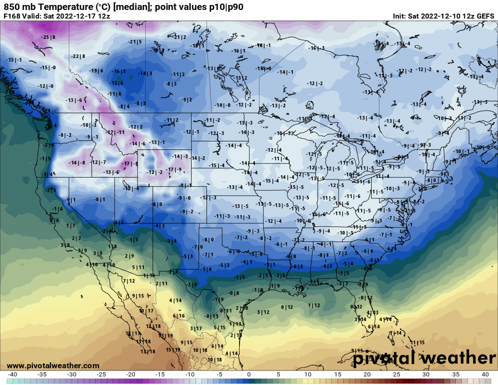
GEFS took positive steps with the PNA. That’s one key teleconnection that keeps looking better by the day despite the insanity for every other run and pattern signal.
-
2
-
-
1 hour ago, GaWx said:
NG market down another 2-3% as of now (~25% down vs Thursday's high!):
https://www.investing.com/commodities/natural-gas
As previously mentioned, this market is often as good a barometer as any of temperature trends in the 14 day forecast in the E US as a whole. SE cold lovers generally want NG to rise on any day. The trend in the E half of the US and especially E 1/3 in the most recent EPS and GEFS run means often has the most effect though the operational GFS and especially Euro 6-10 can have significant short term effect. Thus, NG is telling me that milder trends since Thursday in the E US over the next two weeks are still not reversing as of this moment anyway. We'll see how the rest of the 12Z GEFS as well as the 12Z Euro suite affect NG over the next few hours. A deadcat bounce is due regardless of the wx outlook.
If there’s a bright side to a warm winter, you wouldn’t be able to draw up a worse year for wall to wall cold with the crunch on the energy market right now.
-
2
-
-
It’s generally never a good sign when I’m on about a 10 day streak of seeing a ton of Mets start their tweets with “delayed but not denied.”
but as others have said, generally the teleconnections don’t look bad and perhaps that’s the only thing we should be looking at anyways. The gfs is drunk with the new upgrade and everything else seems to have too many wild swings to take seriously.
-
5
-
-
Also one of you fellas needs to set up a livestream or live reports for one of the better flow setups
 . I lived vicariously through the Buffalo snow king two weeks ago and his reports were incredible. If you missed it, look him up on Twitter or crawl that thread in the upstate NY forum.
-
3
-
-
11 hours ago, Met1985 said:
A lot of chatter on the pattern coming up. One thing I can say is that we are going to be wet. Lots of showers and rainfall which isn't really bad. Currently it looks like the pattern might be changing mid month. To me the later the better because our climo just gets more and more favorable as the month goes on.
Yep I’ve tried to back off my panic from yesterday. I’m just a sucker for a cold December but it does look like we get the PNA close to neutral and borderline positive by around the 13th. We all know that deep down, NAO or not, that’s truly the one piece that matters the most.
-
4
-
-
40 minutes ago, NorthHillsWx said:
Is anyone surprised after the last 4 winters

Never! The only guaranteed cold comes April - Memorial Day
edit: sorry everyone. Just a salty winter weenie.
-
1
-
-
What a disgusting flip in the models. Went from wall to wall cold and a rare setup to mowing the grass and golfing the rest of December.
-
1
-
-
42 minutes ago, Buckethead said:
Colder air is spilling in. We went from mostly cloudy and 48 to dense fog/mist and 41 in the past 15 minutes in Wolf.
Sent from my SM-S908U using Tapatalk
This pattern is about to be unreal for you. The lakes are still warm and those fronts are going to bring a polar express with it. Can’t wait to see how much NWF you can rack up by New Years.
-
3
-
-
I haven’t been this excited by a look on the ensembles in years. We know how it goes…nothing is written until the ink dries but nonetheless, at least things seem to be getting interesting.
-
3
-
-
17 hours ago, wncsnow said:
Long range seems to be up in the air at this point. Some models showing a typical La Nina pattern, others show more blocking and cold air around. We'll see what's right.
That -PNA is going to be the fly in the ointment. We should’ve expected it wouldn’t stay positive. I just hope it flips back before long. The NAO going - is certainly a nice step but a -NAO and a -PNA spells nothing more than transient cool days I’m afraid.
-
1 hour ago, olafminesaw said:
Seems based on the GEFS & EPS, the pattern flips to torch right around the 1st of December. Right on schedule!
Don’t worry! This pattern will re-emerge in April.
-
1
-
-
Next week gets more and more interesting each set of model runs
-
2
-
-
Looks like McCllellanville might be the landfall point soon.
-
Ian appears that he may jog into the coast, south of guidance. That could have a big impact downstream - especially for those that were previously on the cuff.
-
1
-
-
If this thing comes in at Pawleys, it’ll have implications downstream. 20 mile wiggle south as the crow flies.
-
1
-
-
My eyes may be deceiving me but it appears to have commenced a west of north movement now… if so, Garden City Beach?
-
1
-
Mid to Long Range Discussion ~ 2022
in Southeastern States
Posted
This is not a bad look…. Sprawling high over the upper Midwest - which has produced the signature supply of cad many storms before. Clear storm signal to our south……this bears watching and it’s not in fantasy land.