
BooneWX
-
Posts
1,319 -
Joined
-
Last visited
Content Type
Profiles
Blogs
Forums
American Weather
Media Demo
Store
Gallery
Posts posted by BooneWX
-
-
1 minute ago, BretWx said:
Heavy sleet and snow mix here. Snow is trying to win out badly!!
Hopefully we can all switch back over in the next hour or two. Returns to the sw look juicy.
-
 1
1
-
-
What’s up with these temps suddenly torching? Steadily climbing here from 22 just an hour ago. 25 now.
-
Just now, mercurydime said:
Beautiful! Enjoy!!
-
 1
1
-
-
Heavy sleet here as well! I really hope the ULL swings through with decent precip.
-
Officially 4.5 here in Icard, 22/20. We switched to a mix a bit ago but now it’s ripping snow again.
-
22/21 in Icard, heavy snow. I’ll get an official measurement in a bit but it’s looks to be around 4 inches. Eat your heart out GSP!!

-
3
-
1
-
-
Heaviest snow I’ve seen in quite some time here in eastern Burke. Getting pummeled right now!
-
2
-
-
Absolutely puking snow in eastern Burke. Up to maybe about 2 inches.
-
11 minutes ago, wxduncan said:
GSP on there point and click brought back our snow totals for Burke your area and back to Valdese/Morganton now says 3-5inches for today.
Not surprised! I have over half an inch just off of the tiny flakes and pre-heavy bands that dumped in the upstate.
-
I know we’re in the meat and potato’s of this meal but I can’t help but look west to Alabama and Mississippi and see dessert headed our way for this afternoon

-
2
-
-
Moderate snow here in eastern Burke! Half an inch on the ground already. 25/35 with a stiff NE breeze.
-
Moderate snow, 25/23, NE 4 mph, Icard.
Loving every second of it! Maybe a half an inch on the ground.
-
3
-
-
Someone is getting thundersnow tomorrow morning as that band cranks. It looks very convective on the HRRR.
-
3
-
-
That stiff NE breeze is getting more and more noticeable. Up 8 mph here in Icard.
37/28
-
1 minute ago, kvegas-wx said:
These aren't freight trains, these systems can literally stop and turn on a dime once they become influenced by a different feature. If you have a rapidly weakening blocking high to the north and other features in place that would draw the system due north, it wouldn't take long at all for this system to stall and begin moving quickly north. (I'm fairly certain I'm preaching to the choir here, but the statement was made) It can absolutely be in Gatlinburg in 12 hours.
I totally understand that, I think my statement may have been misunderstood a bit. I was simply mocking the absurdity of it - not suggesting it can’t happen. There’s just not a lot of precedent for this storm track.
-
5 minutes ago, StoneColdWeatherAustin said:
Correct me if I am wrong, but I thought the latest models were not showing the low making it to the gulf, but instead around northern LA/MS and then jetting East to SC and then North. Wouldn't the fact that it made it to the gulf cause some pretty different scenarios for a lot of locations?
Sent from my SM-N960U1 using Tapatalk
My eyes may be deceiving me, but it seems like the low is roughly 50-75 miles south of where many projected it to be. The bigger and more important question now is how far east it can slide before starting the climb north.
-
5
-
-
-
Surface low has popped right along the gulf. It’s splitting hairs but it seems like it’s roughly 50-75 miles further south than the HRRR which is already the coldest

-
4
-
-
17 minutes ago, Sandstorm94 said:
Surface low made it to the Gulf coast

Sent from my SM-S115DL using Tapatalk
Color me shocked that it’ll be in gatlinburg from that position in 12 hrs.
-
1
-
-
If either of those models are correct, I’m calling it a huge coup for the GFS
-
2
-
-
Well, after 24 hrs of negative trends, the short range models finally realize that CAD exists!
-
5
-
-
Just now, BretWx said:
Setting my alarm for 3AM, lol.

It was an absolute death band. Near 2 inch per hour rates for a bit.
-
2
-
-
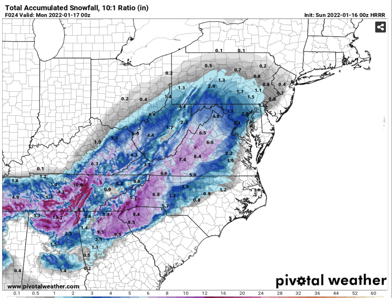
HRRR with 1-2 inch per hr rates in the morning
-
1
-
-
Lol my projection an hour ago is now my “1 in 10” chance.
-
1
-
2021-2022 Fall/Winter Mountains Thread
in Southeastern States
Posted
I’m wondering if this precip has been so heavy over the past hour or two that it’s dragging down some of that warm air above us