
BooneWX
-
Posts
1,326 -
Joined
-
Last visited
Content Type
Profiles
Blogs
Forums
American Weather
Media Demo
Store
Gallery
Posts posted by BooneWX
-
-
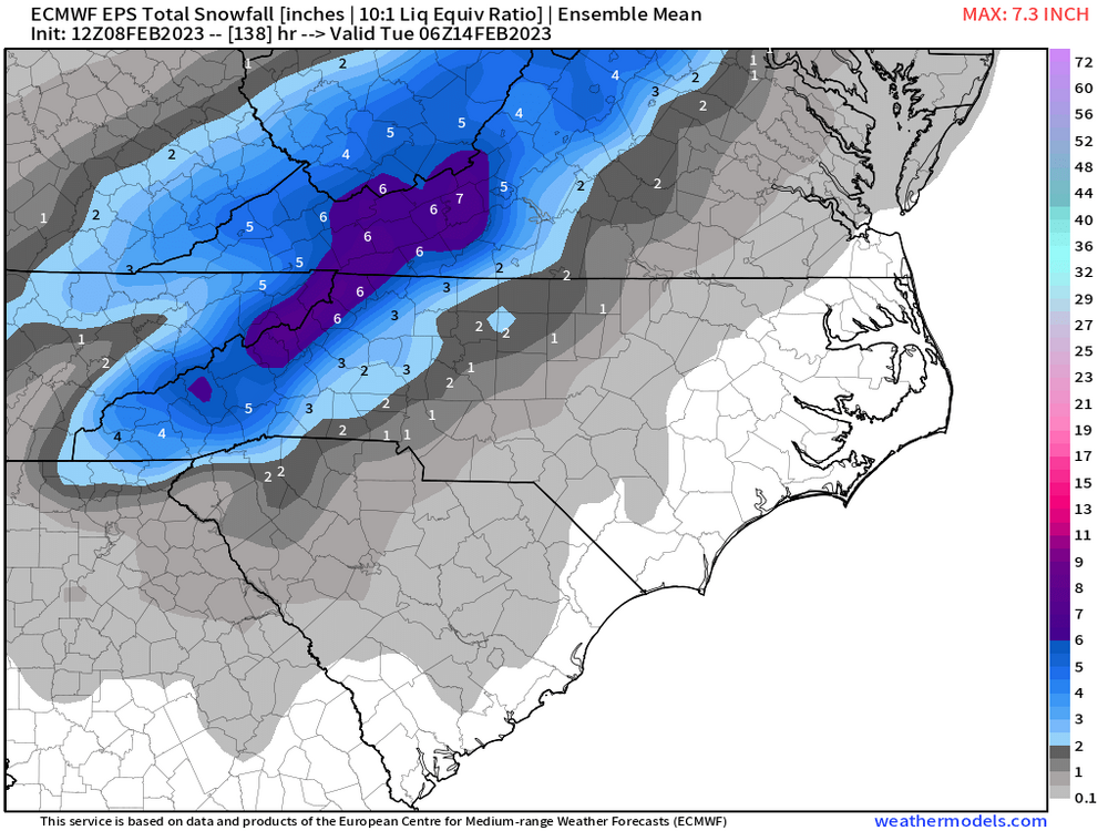
Very good 12z GFS run
-
 1
1
-
-
This is going to be a good run it appears. Could always be better but it keeps it on the table.
-
March 2009 keeps getting thrown around and it may be a good analog indeed. My gut says obviously higher elevations will do well but somewhere in the western piedmont, a death band forms and dumps with temps in the mid 30s. There will be a clear screw zone on either side of that band.
-
2
-
-
Just now, wncsnow said:
Hard pass
I know man. Trust me, I’m not wishing that result on anyone in the Lee. You and I both know that it’s a delicate balance though. ULLs can work in the foothills but you can’t be too far away from the best lift to overcome the sinking air and more times than not, these setups struggle to work out.
-
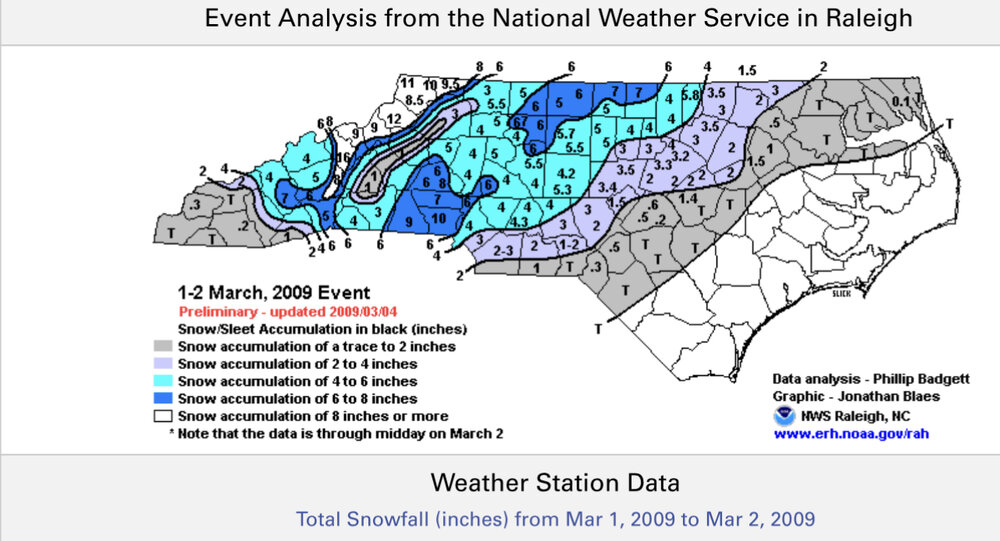
I’ve heard March 2009 be thrown around quite a bit and I actually think that’s a pretty good analog and possibly an evolution we can see. That storm had severe downsloping in the Lee but picked up totals rapidly west and east. Just look at that gradient from just west of Morganton to Hickory!
anyways. The gut tells me there will be two winners: obviously the higher elevations but still someone in the eastern foothills/western piedmont is going to get under a death band of sorts and score with temps in the mid 30s. Good luck to all forecasters trying to pinpoint that spot though!

-
One not so fun trend I’m seeing for the foothills is the clear downsloping signal on the globals. A tale older than time. These setups are notoriously difficult to pull off in the immediate Lee.
-
16 minutes ago, Hvward said:
12z EPS increasing totals again. This is really trending our way.
As always: looking forward to your video update!
-
23 minutes ago, Blizzard22 said:
Sounds like what happens in the summer when some areas get drenched and a few miles away it’s sunny.
Pretty much the exact same convective nature. There’s a reason they call upper level lows a “forecasters woe.” Some will be happy, most will be pissed.
-
2
-
-
This whole setup is going to be extremely rate dependent. I highly doubt anyone outside of the mountains will experience a lot of light snow. It’ll either be snowing cats and dogs or you’ll be getting drizzle and light rain. The joys of an ULL right? Someone under a death band and someone else getting rain a few miles away.

-
3
-
 1
1
-
-
Just now, Tyler Penland said:
Euro looks very elevation dependent on the higher res maps. Showing a lot of mixing on Sunday afternoon.
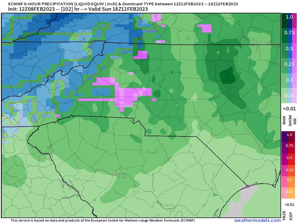
I could easily see an evolution where unless you’re above 3k ft, it’s extremely rate dependent. Which would be fitting, because the joys of an ULL also mean someone doesn’t get under a convective band and has to experience the agony.
-
Would’ve loved to have seen the NAM go out about 6 more hours because she was preparing to unload.
-
1
-
-
It’s late in the range but the NAM looked primed to go boom.
-
GFS paste bomb!
-
-
Nothing like seeing the Hot sign on
-
1
-
-
Always hate the risks associated with ULLs but in this pattern, that’s how we can score. Those would be some absolute fatties falling if it were to unfold.
-
1
-
-
36 minutes ago, nchighcountrywx said:
What’s even wilder is that Mt. Washington is literally located in the stratosphere tonight. Those are true polar vortex winds.
-
1
-
-
You could make a very convincing argument over the past decade that the worst location for snow in NC is the Lee/escarpment. It sounds asinine given the CAD potential and higher elevation but dang. Downsloped on flow and eastward tracking upper lows. And many storms phase too late for us to be part of the fun. 2018 was nice but holy cow I don’t remember a time where we’ve been in snow poverty worse than this stretch of years.
-
2
-
-
I officially have more rain in the month of January at my location than inches of snow over the past 3 years.
edit: forgot the upper level low in Feb 2021 that brought me a few surprise inches but still pretty close

-
4
-
 1
1
-
-
I’m personally pulling for a record breaking SER that cuts the storms through the plains and ends this deluge of water each week.
-
 1
1
-
-
-
Just hang on, happy hours gfs never disappoints
-
1
-
-
33 minutes ago, wncsnow said:
Get your boats ready..
.thumb.png.165c7fd15a57bb8d62333ed31e2a8790.png)
6.3 inches on the year already! This week should get me close to 7 and a half.
I sound like a broken record but it’s an absolutely absurd pattern that we’ve been in since October. I thought 2018 couldn’t be topped but we’ll be well on our way in WNC.
-
26 minutes ago, wncsnow said:
I'm sure it will be in the 20s and windy for the opening of trout season in April
Hey now. It makes finding a rock to stand on all that much easier.
-
1
-
2
-


.png.29c678dc522928b555deac3227db5df5.png)
February 11-12 ULL Winter Storm
in Southeastern States
Posted
As a fellow foothiller I think we have a good shot but there’s no denying the high risk for downsloping to completely ruin the event.