
BooneWX
-
Posts
1,325 -
Joined
-
Last visited
Content Type
Profiles
Blogs
Forums
American Weather
Media Demo
Store
Gallery
Posts posted by BooneWX
-
-
One thing I really liked that I haven’t seen in a while: the models despite a pesky SE ridge were honking with CAD signals. That gives me some optimism that we could at least score a Miller B type of setup in the next few weeks.
-
 2
2
-
-
2 hours ago, GaWx said:
What a contrast to KSAV, which has had only 5.85" since way back on September 12th vs a normal of 12.54"! This comes out to only 47% of normal over the last 4 months. But this is fairly typical of La Niña, which favors the driest in the SE closer to the SE coast thanks to the prevailing southeast ridge mainly November through March.
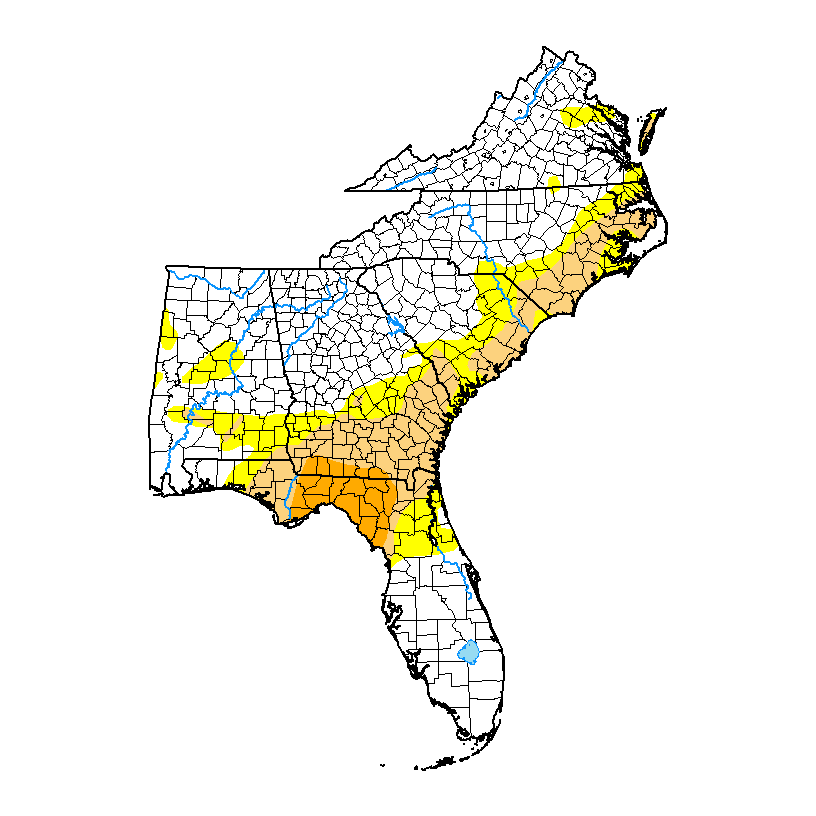
Here's the latest SE Drought Monitor map, which comes from here:
https://droughtmonitor.unl.edu/data/png/20230110/20230110_southeast_none.png

Interesting! We’ve been so wet in western NC that I was frankly oblivious to any drought conditions this close by. Other than 2016, I can’t really recall when we’ve truly been substantially below average in this part of the SE. We had a 2 week dry period this august and no lie, I think that was the first time I’ve mowed my lawn and had bone dry wheels in 3+ years.
-
1
-
-
10 hours ago, wncsnow said:
With the big trough digging in the midwest, it's going to get super wet and its not exactly dry currently. I can see some flooding issues coming soon.

I’ve had over 16 inches of rain since the beginning of November. I’d trade snow for an immediate torch and dry weather if given the opportunity.
-
3
-
-
My god I miss living in the mountains
-
3
-
-
If it’s going to be warm, I just wish it could be dry. At this juncture I’d trade snow for no rain until March 1st.
-
On my second snow shower of the day down in the hills. A pleasant surprise.
-
1
-
-
My goodness that radar is juicy upstream
-
4
-
-
Looking forward to Friday. I’m in a weird spot in the foothills that always seems to see some non-accumulating token flakes flying during robust events. Might be all I see this winter so I’m going to soak it in!
-
2
-
-
14 minutes ago, CaryWx said:
Please look at the composite ensembles for the other major LR models. Criminy folks
I was just making a generalization about the pattern and likelihood of a Nina year producing Feb cold. We need those same ensembles to start showing a change in the medium range because they’ve been showing a long range “change” for about 2 and a half weeks.
-
55 minutes ago, NorthHillsWx said:
06z GFS punts the pattern change till February, if at all
The latter would probably be more likely in a Nina year. We desperately need things to flip this month or it might be time to start getting the lawn mower serviced.
-
It’ll be great to have a +PNA, but one thing that concerns me is the position of the ridge on the west coast. The center of that ridge being in the eastern pacific just west of Seattle ain’t gonna cut it unless you’re moving to Ohio shortly.
-
1
-
-
The mountains are about to feast. I may make the trek from the hills to see it. An afternoon walk on the parkway may be calling on Saturday.
-
2
-
-
Luckily, a PV disruption is looking very imminent, so I’d assume long range models will start to trend colder.
-
2
-
-
-
3 minutes ago, StantonParkHoya said:
Bradford Pears will be blooming in 7 weeks
Nah, El Niño is going to spring up at just the perfect time to delay that and give you a March and April full of cold rain dreams.
-
 2
2
-
-
9 minutes ago, Met1985 said:
Yeah yall in the foothills may be blanked.
El Niño setting up just in time to make sure the crawl to warmer weather is delayed come spring as well. Sheesh…
-
1
-
-
2 minutes ago, wncsnow said:
Here's a shot of dopamine
.thumb.png.872a2be81fc5a50e695a40d23edaa0e6.png)
Roxboro with the max totals already tells me I need to believe this will be the solution
-
2
-
 1
1
-
-
Hard to hate that run if you’re in east Tenn, N Ga, the Upstate or the western 2/3s of NC and VA.
-
WARNING. The 12z Euro is NSFW.
-
2
-
-
On 12/26/2022 at 8:58 AM, BooneWX said:
Did anyone try asking Santa for a Miller A with a track that goes over Savannah and Myrtle Beach with a 1040 high over Ohio? I thought about it too late.
Looks like Santa is only giving out Miller Bs for 2023.
-
Good Ol’ Miller B. Setup ironically looks a lot like the storm preceding it by 365 days.
-
 1
1
-
-
I wouldn’t completely hate this torch if it could come without the rain for once
-
Anyone else worried about the PV disruption coming? I see a lot of fellow weenies on Twitter celebrating but I’m trying to recall the last time that setup has benefited the US east coast. Usually that’s a suppression signal and some extremely dry air.
-
51 minutes ago, GaWx said:
The ensemble model consensus continues to suggests no return to a cold dominated pattern in the SE US and the E US in general through the next 7-10 days. After that it is a tougher call as is typically the case when going out past 10 days. But admittedly nothing exciting on the cold side is yet showing on the ensembles in the 11-15 despite the MJO still progged to be in a supportive position to allow for cold to dominate once into mid January. The 0Z EPS was pretty close to yesterday's EPS with only a weak to borderline moderate +PNA after day 10. The GEFS still has a moderate +PNA (~+0.6 vs +0.5 yesterday) while the AO forecast is still solidly negative after day 10 (still sub -1). But the NAO is a little higher today (near +0.5 vs +0.3 yesterday), which is not supportive of cold.
Expect model volatility in the 11-15 due to the conflicting signals of cold supportive MJO/AO and slight cold support from the modest +PNA vs the support for mild from the +NAO. I'd think a cool off down at least to near normal averaged out would be quite doable.
We’re going to initiate our own pattern change via snowpack next weekend.
-
1
-


.png.bcb991a4d37947f0890c07d9d95d0ed0.png)
Mid to Long Range Discussion ~ 2023
in Southeastern States
Posted
Thank goodness! Saw 2 days of dry weather on the forecast and started to get concerned it was going to become a trend.