
BooneWX
-
Posts
1,325 -
Joined
-
Last visited
Content Type
Profiles
Blogs
Forums
American Weather
Media Demo
Store
Gallery
Posts posted by BooneWX
-
-
Ya know what they say about the tail end of patterns
-
 1
1
-
-
Just now, wncsnow said:
Don't think this upcoming pattern is the one. Probably best to blow it up with a warmup and start over in January.
Was just thinking the same thing. My biggest fear from the start was that the push of cold would be too much. When people started talking about the piece of the polar vortex breaking off, I had a bad feeling. It’s such a balancing act and this surge is just too overwhelming to kick off anything meaningful in our area. I’d love to see one good classic setup in Jan or February where we can get a sprawling high over upstate NY and rely on true CAD.
-
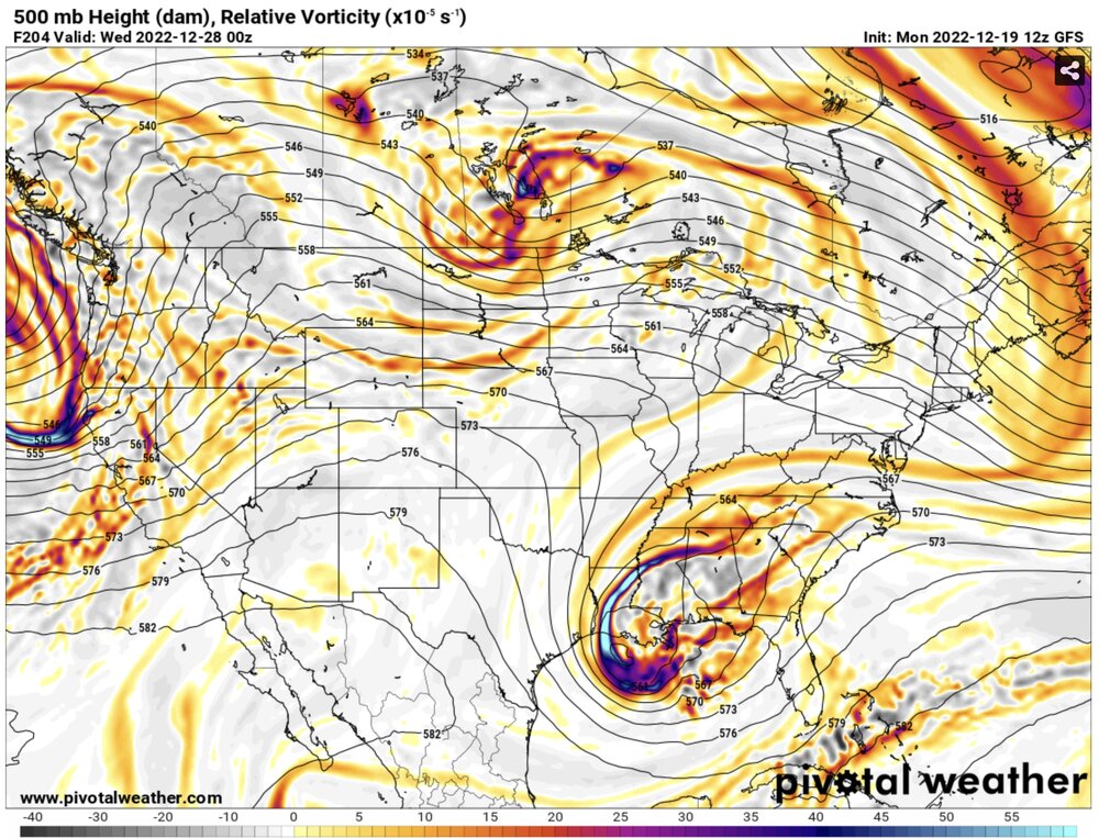
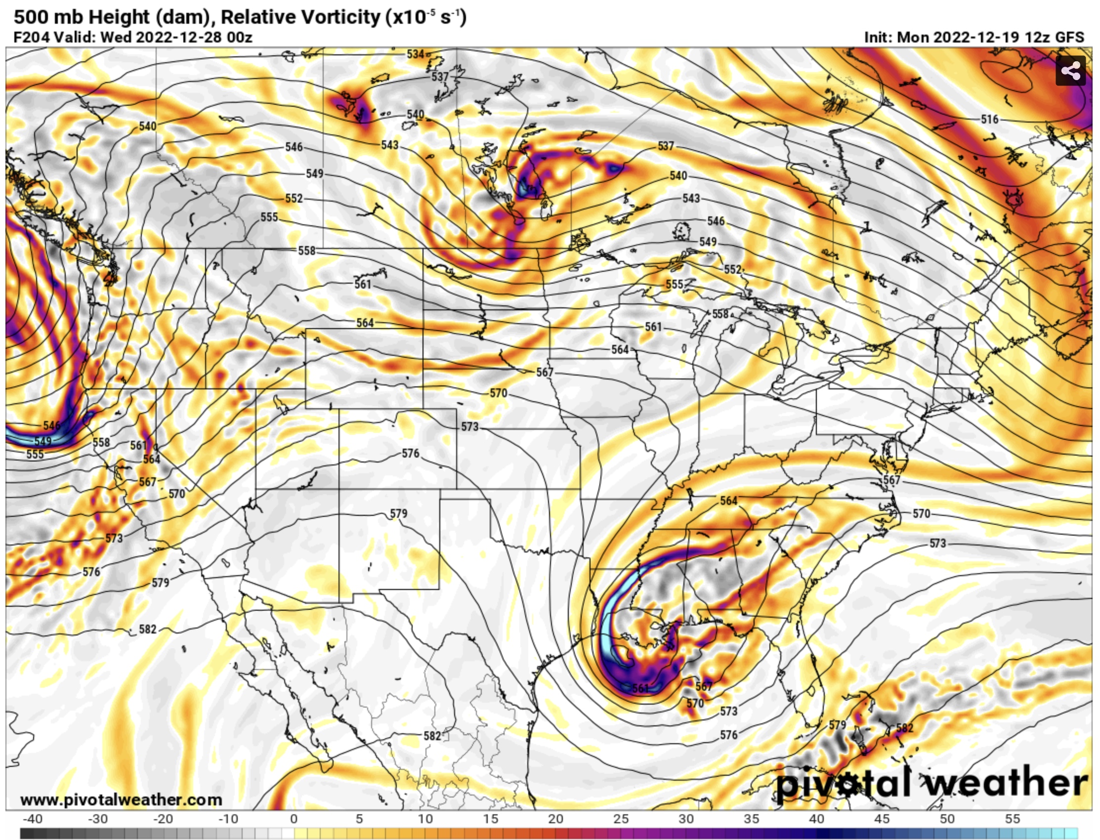
Hour 72 on the NAM is such a teaser. That 1041 high over Canada almost gets the job done but it’s just a bit too far away to make it happen.
-
1
-
-
17.2 this morning. We live in a cold sink, so I’m at least excited to see what happens over this next week. Won’t be surprised if I can hit single digits Saturday morning.
-
2
-
-
Best advice I have for everyone to consider, if you get some spare time or a weekend where northwest flow is forecasted, don’t hesitate to head up with the family. A lot of people don’t realize it, but when they close the parkway for snow, it’s open to recreation. Take the sleds and enjoy. I know it’s never the same as snow in your backyard but it’ll satisfy the itch enough. I’m down in Burke County now, but always try to go up when a big flow event is forecasted.
-
4
-
 1
1
-
-
46 minutes ago, SnowDawg said:
Man if that warmth aloft is overdone even in the slightest, this could turn into a really nice snow event all things considered. NAM now showing around a qtr inch or more QPF area wide for Tuesday.
Hunter called it!
-
Hope this trends drier. I’m absolutely sick of the rain.
-
1
-
1
-
-
20 minutes ago, Sandstorm94 said:
0z so far:
GFS: Improved
ICON: improved
CMC: improved
Sent from my SM-S102DL using Tapatalk
You can toss the UKMET in the improved department too
-
Yea and it’s important to stay wary of the main thread. For most, I hate to say it, they live in areas where storms in borderline perfect setups don’t work in their favor. And when they don’t, it’s all pessimism and hate for anyone that does score.
-
2
-
-
I need a stiff drink
-
1
-
-
ICON much closer to the GFS solution
-
1
-
-
Annnnnnnd we’re back to an east coast solution. Gonna be curious to see if we get any level of agreement from the euro.
-
1
-
-
And the windshield wiper continues
-
Ridge looks flatter than 18z at hr 90 but let’s see how this goes
-
Even if it trends towards 2 inches of rain it just feels so dang good to be tracking something - anything.
-
3
-
-
8 minutes ago, olafminesaw said:
I guess one of the biggest struggles is not really knowing what something halfway in-between these two solutions would even look like. I suspect mostly rain for most with a thump of snow on the back end, with the low tracking over the Apps and phasing late.
I’m chuckling because you’re 100% right - how do you split the difference between a foot of snow and a severe weather outbreak?
The models are laughable at this point and the most we should take away is that the ensembles show a favorable pattern.
-
For what it’s worth, the gfs and GEFS have been consistent with the signal for days.
-
4
-
-
1 hour ago, Met1985 said:
No roasting here. We are literally 7 days out in an anomalous pattern change and blocking. People talk about the gfs being erratic.... Um the Euro went from showing snow in the south to a damn cutter so tell me which model is erratic.... I don't really believe both currently.
Another angle of that to consider: the GFS and a vast majority of its ensembles have honed in on a similar setup for days and continue to do so. It’s the only one without the major swings you described. Consistency matters.
-
3
-
-
I’ll get toasted and roasted in the other thread if I say this, so I’ll say it here: the gfs is on an island but I couldn’t tell you the last time I saw the Euro have a correct solution at day 7 either. Last January’s storm, the gfs was completely on an island.
-
3
-
-
4 minutes ago, StantonParkHoya said:
Isn’t there a rule about NS interaction, always check with the UKie?
It’s a similar look to the GFS at 144
-
2 minutes ago, Cheeznado said:
Everybody take a deep breath. The fact that this is so much different than the previous run and light years different than the 00Z Euro makes me highly skeptical. I think someone may get plastered, sure, but posting all these clown maps is just getting everyone into a tizzy way too early in the game, Now if the ensembles and 12Z Euro trend this way, I may get just a bit more interested.
It won’t be heartbreak if I don’t go ahead and set myself up for disappointment now
-
Central VA measuring in feet
-
Widespread foot+ Mts, foothills, piedmont
-
1
-
-
982 off of Cape Lookout MY GOODNESS
-
2
-
Mid to Long Range Discussion ~ 2022
in Southeastern States
Posted
I was so optimistic when it made it to Louisiana and then it just stops dead in its tracks with CAD firmly entrenched to the north lol. We can’t get a break.