

BooneWX
-
Posts
3,607 -
Joined
-
Last visited
Content Type
Profiles
Blogs
Forums
American Weather
Media Demo
Store
Gallery
Posts posted by BooneWX
-
-
4 hours ago, Upstate Tiger said:
And no sign of a breakdown in this pattern for the next 2 weeks. It's one thing to experience summer onset drought after planting and growing season but during planrting and growing season is disastrous. Feel for the farmers in my area...
It’ll break down Memorial Day weekend. Like clockwork, always does!!
-
 1
1
-
-
12 hours ago, suzook said:
Grounds at Augusta haven't looked worse. Sprinklers can only do so much
Saw a lot of commentary online criticizing them for it too. People have no clue how hard it is to get any grass looking healthy in a drought with Georgia heat, let alone bentgrass greens. I agree, irrigation helps to a degree but it can’t replace the type of soaking that rain delivers.
-
1
-
-
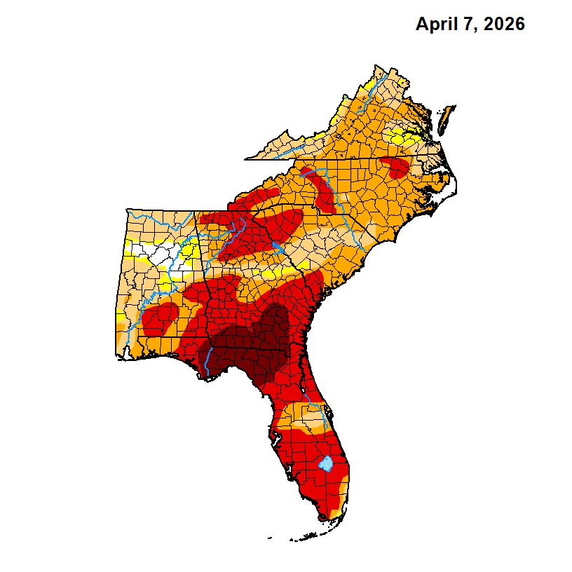
57 minutes ago, GaWx said:
I’ve been sprinkling the yards recently. The drought in this area and especially to the SW is about the most severe in the entire SE with widespread D3 (extreme) here to D4 (exceptional) in SC GA to NC FL. See map below.
Although it’s unpredictable, the good news is that a strong El Niño appears to be on the way. If that verifies, much of the SE should see wet relief by November based on history and long range models:
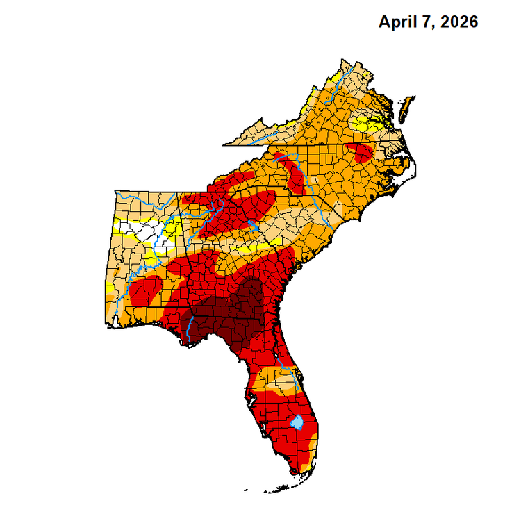
I’ve went into my full July irrigation schedule here. Even with it, this is probably the worst the lawn has looked in April in years. I have Texas Bluegrass that spreads with rhizomes like Bermuda and its repairing ability has completely stalled out these past few weeks.
-
 1
1
-
 2
2
-
-
On 4/7/2026 at 7:55 AM, calculus1 said:
Only 0.09 inch here. It is so very dry…
.Probably the first time I’ve seen the clay cracking in April
-
The forests in the western half of NC are littered with dried debris from Helene. It’s a powder keg and I’m afraid one cigarette flung out of a window could cause a disaster.
-
.37 is my total. A bit disappointing but I’ll take whatever we can get.
-
1
-
-
Yes, you’re welcome in advance:
https://weather.com/retro/
.-
6
-
 1
1
-
-
Nothing like watching a robust cell dissolve in 2 frames, just 1 mile from your house after it survived a 2 county trek
.-
1
-
-
I’ll jump on the big yikes bandwagon. It’s been so dry that even a week into restarting my irrigation on the lawn, it’s still dormant for the most part and in mid winter form.
-
30 here…thinking that may be the last sub freezing reading of the season. What do yall think?
-
Hoping tonight delivers at least a few light showers. My sinuses are getting whipped worse than ever.
-
30.7° at 10 am is just flat out impressive for this time of year
-
2
-
-
4 minutes ago, Met1985 said:
Also the GFS did the best job on this again. The Euro wasn't even close.
It’s impressive how bad the gfs performed coming into winter, then it woke up from coma swinging with brass knuckles.
-
3
-
-
The line just moved through my neck of the woods. No lightning, heavy rain and maybe a few gusts to around 30mph. It’s definitely getting its act together as it marches east though.
A lot of Charlotte cams showing the same clearing I saw earlier. What are you folks seeing further east?
-
Yall are going to get smoked later! Enjoy fellas.
-
2
-
-
Not even a clap of thunder! We’re lucky it’s moving through in the morning though, it’s impressive how well it became organized when it hit higher dews east of the escarpment. It’s going to be a rough day for the piedmont.
-
2
-
-

Those are clear skies an hour after that first line and not a long distance from the main line here in the foothills. That can’t bode well for folks down east.
.-
2
-
-
Today is sneaky. I think for those along and west of I-77, it’s worth not getting lulled to sleep and distracted by Monday’s headlines.
-
 1
1
-
-
18 minutes ago, kayman said:
I'll be prepped and ready to go to my basement on Monday if I need to. This looks like it will be one that will be developing on top of the Metro Charlotte area from the Hickory/Unifour portion southward towards Shelby in Cleveland County. It will accelerate eastward through the midday-afternoon hours. This is could be bad for the Triangle, Greater Richmond, the Metro Washington area AKA the DMV, and Metro Baltimore. Especially, if there are individual supercells form ahead of main squall line or the line potentially forms as line segments with embedded supercells.
Situations setting up like this on Monday is why Metro Charlotte needs a NEXRAD Doppler radar site & its own NWS forecast office to provide better radar reflectivity below 5,000 feet in its region. This would also help the Winston-Salem & High Point side of the Piedmont Triad area as well with better lower-level radar reflectivity coverage.
Yep. The poor radar coverage a few years ago caused a tornado to go unwarned in Catawba County and multiple people died.
-
2
-
-
All of the short range models are starting to slow that front down. Any more ticks west with time and even more folks in the Carolinas and Virginia are going to be under the gun.
-
1/25 - 2.5” of mostly sleet
1/31 - 7” of champagne powder
2/5 - 1” of icing on the cake to freshen up my champagne powder
Season total: 10.5”
Notable: Several cold periods with rare staying power. I went about 3 weeks with some sort of ice/snow coverage on the ground.
Complaints? Few. Wish Christmas would’ve been cold but it felt like a winter of old.
Final grade: A+
This winter reminded me so much of when I was a kid in the foothills. Multiple storms, including one good slop fest, a true snow and sneak-up event that was minor. It’s hard to be mad at this past season. I really hope this is the start of a better long term pattern, and even if it’s not, it was good to see we’re capable of going above average in snow/sleet accumulation not entirely dependent on one event.
-
26 minutes ago, wncsnow said:
For me its-
1/17- .25" surprise dusting
1/25- 2" of mostly sleet .25 ZR
1/31- 5" of wind blown powder
2/5- .5"
Season total- 7.25" and .25 ZR
Final Grade- B+
I can't give it an A here and quite frankly its more of a B or B- when comparing to the 30 year average but when comparing to the last 10 years it was a solid winter. We broke our non WSW criteria drought, had multiple events for the first time in years and quite a bit to track during that 4 week period. I can't give it an A because we still didn't get a true southern Miller A paste bomb and it was generally dry.
You guys got shafted on that 1/31 storm but at least it still beat warning criteria for sure.
This winter ranked high in the excitement category. I still can’t believe we had almost a full month of wall to wall tracking. I absolutely can’t remember the last time that happened.
-
1
-
-
Wrapping up this winter:
1/25 - 2.5” of mostly sleet
1/31 - 7” of champagne powder
2/5 - 1” of icing on the cake to freshen up my champagne powder
Season total: 10.5”
Notable: Several cold periods with rare staying power. I went about 3 weeks with some sort of ice/snow coverage on the ground.
Complaints? Few. Wish Christmas would’ve been cold but it felt like a winter of old.
Final grade: A+
This winter reminded me so much of when I was a kid. Multiple storms, including one good slop fest, a true snow and sneak-up event that was minor. It’s hard to be mad at this past season. I really hope this is the start of a better long term pattern, and even if it’s not, it was good to see we’re capable of going above average in snow/sleet accumulation not entirely dependent on one event.
-
1
-
-
Monday is looking interesting. We’re going to be in the warm sector of an incredibly dynamic storm system. Would not be shocked for the severe weather outlook to continue its uptick in the coming days.
-
 1
1
-
Mid-Long Range Discussion 2026
in Southeastern States
Posted
It’s coming. It’s just a question of how much fescue you’ll lose between now and then.