
BooneWX
-
Posts
1,323 -
Joined
-
Last visited
Content Type
Profiles
Blogs
Forums
American Weather
Media Demo
Store
Gallery
Posts posted by BooneWX
-
-
Man what a flip overnight. The long range had hinted at the 4-6th timeframe for days but that Euro run made me knees weak.
-
9 hours ago, WiseWeather said:
Gimme the beat boys and free my soul… i wanna get lost in your rock and roll and drift away!

.Murphy to Manteo!
-
-
Clown maps aside. The gfs shows the potential that we’ve waited all winter long for. Feb has always been the target with a strong El Niño, so let’s see if it can deliver. Lord knows this forum needs it lol.
-
1 hour ago, WiseWeather said:
Dont look at the 6z… holy shit…
.Too late!!!

-
 1
1
-
-
This sub forum needs a blockbuster storm like a fish needs water. We’ve never been collectively down this bad as a group.

fwiw, I see both sides being right. The cold dumped east, just not east enough. Unfortunately for us, the trough didn’t dig into our area which kept it mostly seasonal - save a few days - and bottled it up west of the apps. We really were just a few hundred (less in many cases)miles from an all-time week here. It just didn’t pan out.
Two things we appear to be getting that we haven’t had consistently in a while:
- a +PNA
- one that pushes into Alaska and makes the energy more likey to dig where we need it. We haven’t had a good synoptic storm in so long because the pacific pattern sucks. An -NAO is useless if the PNA is junk. Hang in there!
-
3
-
 1
1
-
-
1 hour ago, Met1985 said:
Euro Weeklies. Heading into much better territory.
Sent from my SM-G998U using Tapatalk
And the timeline has moved up quite a bit!
-
2
-
-
26 minutes ago, wncsnow said:
You know deep down what will happen. A few cold days then warm up and rain.
You’re probably more likely to be right but idk. I have a funny feeling about mid-Feb. Eventually the streak of no-snow ends and it may be next year but I’ll hang on to hope even if it’s false hope until Feb 25th.
-
3
-
-
4 minutes ago, strongwxnc said:
picked up .34" overnight. More wasted potential
")
It’s always this progression:
cold—-brief warm up—-rain——cold——brief warm up
on the bright side, the pattern is reloading. Is this our shot? Idk. If we get to Feb 25th with nothing, I’ll be ready to punt our way into spring. I’m still optimistic for now though - it’s probably the best pattern in a while for our region since the cold doesn’t look displaced too far west.
-
It even has 2 inches into Asheville
-
1
-
-
That is a STOUT nwf signal on the 12z gfs for Sunday
-
1
-
-
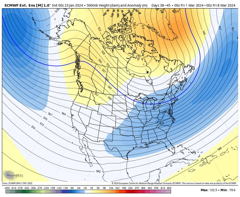
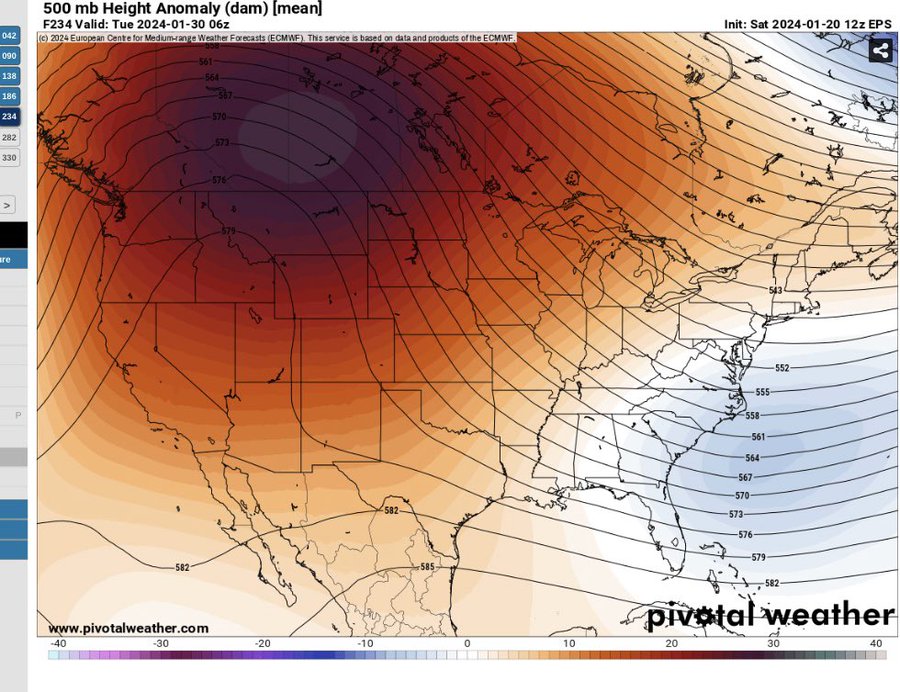
Weather really does have a memory it seems. In December we were given this exact picture of a death ridge that would rule for 3+ weeks and it ended up being slightly above normal at best with some legitimately warmer days on the front end like this week. The upcoming pattern screams opportunities for CAD and progressive cold shots. It won’t be an ideal pattern for winter weather but when is it ever?
-
3
-
-
7 hours ago, JoshM said:
Even our fantasy storms are shit now


great La Niña we’re having
-
 1
1
-
-
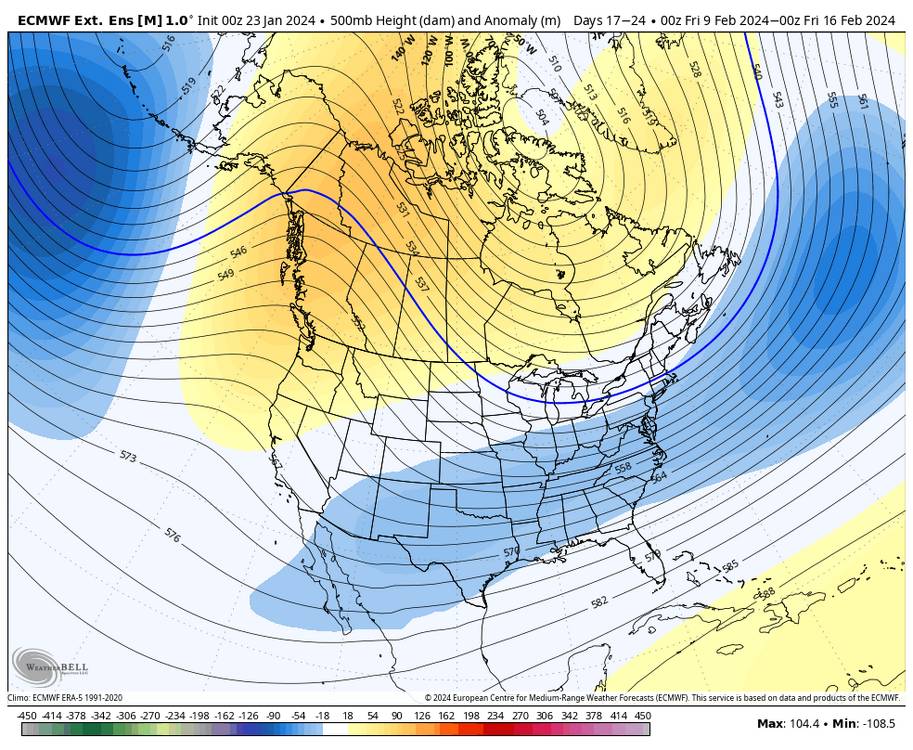
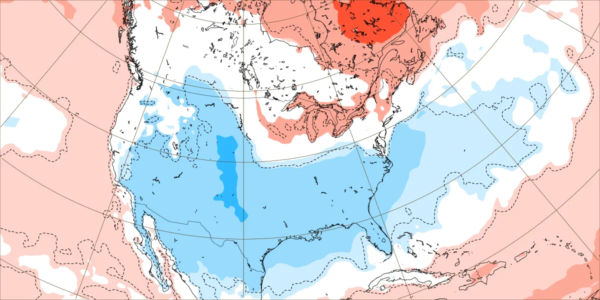
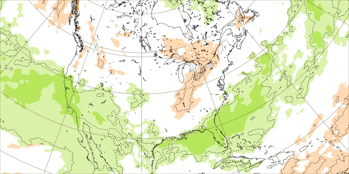
9 minutes ago, GaWx said:
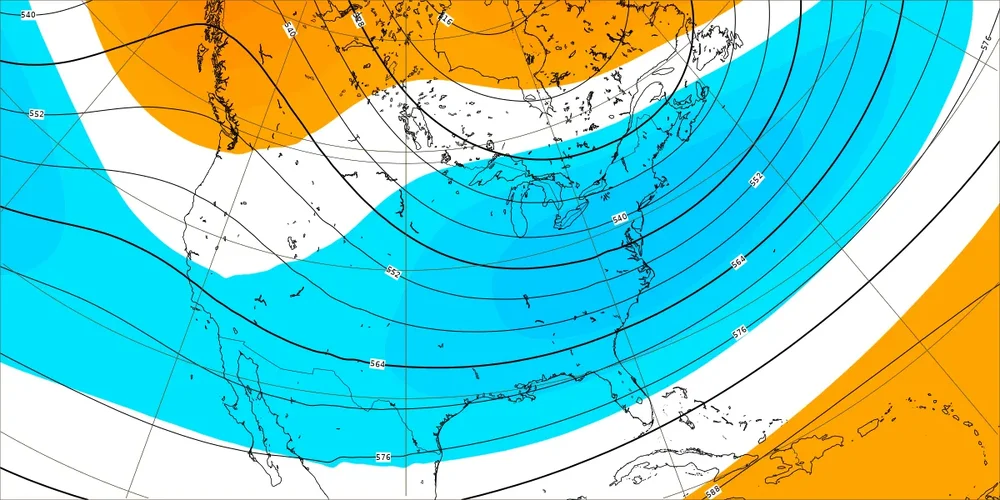
New Euro Weeklies for Feb 12-19: Does this look at all like winter is over in the SE? Not to me unless we’re playing the game of opposites.
H5 hts are lowest of any run so far in SE and also suggests split flow with both a +PNA and BN hts from S CA/Baja eastward typically associated with moist subtropical jet:
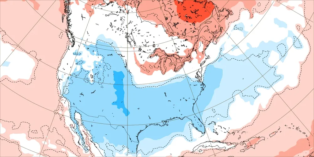
Easily both the strongest and also most widespread BN temperature signal yet by far and it has been getting progressively colder:
Check out the wet subtropical flow from S CA/Baja into SW US/MX and then over N GOM/Gulf coast/S GA/S SC to NC coast and offshore SE US with all of the SE near to wetter than normal:
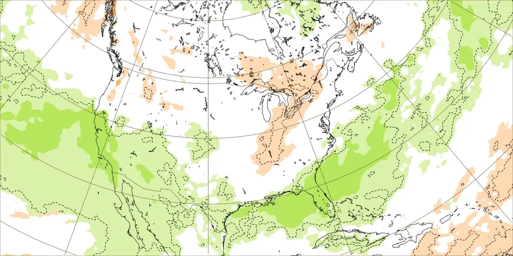
This combo of maps is suggesting an El Niño induced GOM Miller A mixing with widespread cold that would be a near perfect setup for a widespread major SE winter storm near the most favorable climo for it (moderate or stronger Nino in mid Feb). I couldn’t have drawn week 4 maps any better than these to suggest such potential. Now whether or not these maps are matching anything likely even close to what will happen is probably something worth discussing. But I’d much rather see them than not!
Hopefully in the next few days we can move the timeframe up a bit. I saw the MJO looks to be progressing faster on todays plots after looking like it was going to slow down in the warm phases.
The back half of winter was always the timeline with a strong nino, it’s obviously just not comforting to many of us on a 700+ day snowless streak.
-
6
-
-
12 minutes ago, CAD_Wedge_NC said:
You must have been close enough to the lake to get the warm water influence. Just a thought....
I’ve been wondering the same for me since we moved to our new place. I was in a cold sink in rural Burke County but we moved into a new place about 200-300 yards back from the water and it stays significantly warmer at night here.
-
1
-
-
14. Sort of ready for this warm up - just wish it wasn’t wet!
looks like the pattern reloads and delivers the second week of Feb. It’ll be a race against time with the sun angle changing but one of these days Feb is going to deliver again. Why not this year?
-
2
-
-
1 hour ago, strongwxnc said:
30.6 was the high today! Solid pond and icicles in the creek today on our land today.

.Beautiful piece of property!
-
23 and the sun is still up
-
24 minutes ago, WinstonSalemArlington said:
You couldn’t ask for the ridge to be in a better spot
-
1
-
-
Ain’t gonna move anymore. Trending down. 29 was the cap here as well. Brutally cold night in store.
-
Greatest snowfall event of my life was Feb 2014 at Valentines. I won’t quit on this winter unless we get to the 25th of Feb or so and it looks warm in the extended range.
-
2
-
-
The torch in December also wasn’t as torchy as we thought it’d be. A couple well above average days but mostly muted by endless rainstorms - which, looks exactly like the upcoming pattern.
-
3
-
-
Flow still flowing?
-
15 minutes ago, wncsnow said:
Only 18 here. Wind kept going all night. Cold but not frigid.
My suspicion is a bit of Downsloping because my wind has been more westerly than northwesterly. I’ll be curious to see where we max because I’m hard pressed to believe it stays under freezing now but maybe.
-
2
-


2023-2024 Fall/Winter Mountain Thread
in Southeastern States
Posted
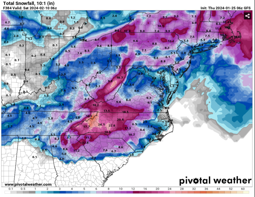
Are my eyes deceiving me or is the NAM suggesting the smokies get smokied by 30+ inches??