eduggs
-
Posts
5,950 -
Joined
-
Last visited
Content Type
Profiles
Blogs
Forums
American Weather
Media Demo
Store
Gallery
Everything posted by eduggs
-
Currently light snow in Putnam County NY where I am at the moment. Snow took a while to get going.
-
Mesos have been ticking slightly colder in NNJ and SENY, but the HRRR and 3KM NAM ptype graphics both look too "cold" in EPA. More mix (IP/ZR) than modeled seems to be being reported further north. It might mix out to snow at times, but the mix line looks fairly far north on radar (matching obs).
-
Two things I've noticed while looping recent HRRR runs... the model has been playing catchup for 6 or 7 runs on temperatures overnight. It has been steadily correcting colder throughout the Northeast. And it hasn't been correcting (i.e., trading off) dewpoints to compensate. It's a cold airmass. The second thing that is well depicted is the strong surge of warmth/higher dewpoints coming from the SSE right into our area during the day tomorrow. That should warm the boundary layer in a hurry. That suggests maybe there could be a quick burst of snow/sleet (surprisingly heavy?) to just west of I-95 tomorrow morning with snow then changing to rain pretty far north of the area as the day progresses.
-
T and Td are expected the surge towards dawn as the storm arrives. But it can't hurt to start off from the lowest possible point. Even a degree or two could help. I also want to counter the notion that we don't have enough cold air for snow and the idea that "if only it were January..." The problem isn't lack of cold or time of year. The problem is the mid-level shortwave is progressive and too far north. This could happen any time of year.
-
At 8pm, dew points are in the teens throughout the area with temperatures mostly in the 30s and some 20s in outlying and radiationally favored spots. That's a decently cold antecedent airmass.
-
The 18z RRFS is a touch cooler along the rain/snow line in EPA and NNJ, which allows some of those areas to claw back a little bit of snow that was "lost" at 12z. The 18z HRRR might have been a hair cooler too. A small SE shift here at the end would be huge. But realistically this will be a nowcast situation for areas right along the boundary. The mesos being so warm at 12z was concerning.
-
First Winter Storm to kickoff 2025-26 Winter season
eduggs replied to Baroclinic Zone's topic in New England
ICON and RRFS are south of 12z -
Sleet and rain now. But the surface temperature continues to drop. 34.7 now down from a morning high of 37.4.
-
It's a little unusual to see snow accumulation on trees, grass, and car tops in the middle of the day and snow fog/ low visibilities with surface temperatures between 35F and 37F. And outside of a few bursts, the intensity hasn't been all that great either. This is an overperforming airmass.
-
Snowy morning at 500ft in Morris County. Nice surprise coating! The bigger surprise is that the temperature has dropped almost 2.5 degrees since 10am allowing the trees to become increasingly frosted. Feels very festive.
-
Chicago has had 13 straight hours of snow and moderate snow for the last 5, with more to come and temperatures in the 20s. Jealous. For reference, Chicago averages about as much snow annually as the interior Lower Hudson valley.
-
First Winter Storm to kickoff 2025-26 Winter season
eduggs replied to Baroclinic Zone's topic in New England
5 days ago there was barely the hint of a ripple of a shortwave across the central US... And a big trof along the west coast.
-
First Winter Storm to kickoff 2025-26 Winter season
eduggs replied to Baroclinic Zone's topic in New England
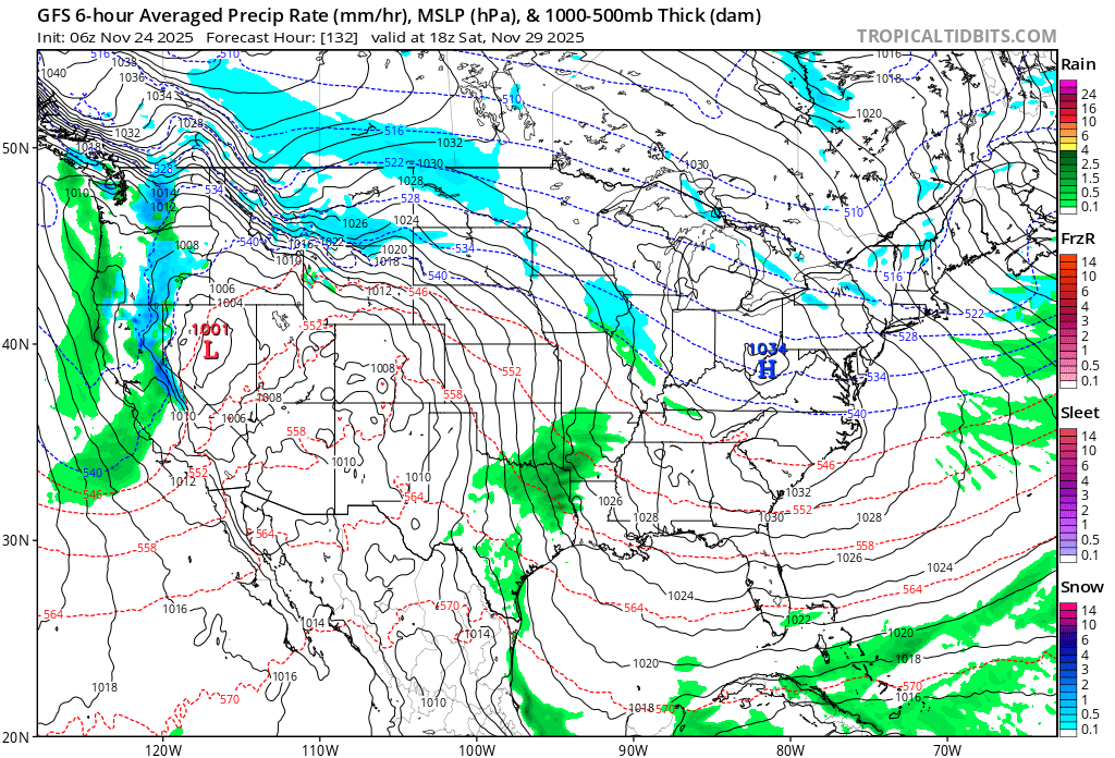
There's more going on than whether it's amped or flat. There's the location and amplitude of the shortwave, location of vorticity advection, the tilt of the trof, and its evolution over time. Some runs over the past few days have been "amped" with a sharp shortwave and associated vortmax taking a northerly route near the Great Lakes into NYS (e.g., 0z 28th GFS) and others have been "ampled" but with the shortwave taking a more southerly track from AR through KY to VA (e.g., 06z 27th ECM). Other runs have been a little flat initially but amped up late (e.g., 0z 29th ECM) or initially amped only to quickly flatten (various CMC and UK runs). This combination of variables has led to a spectrum of outcomes that defy a simple binary description. -
Not a fan of 12z. Noticable shift towards the GFS-like emphasis of vorticity near the Great Lakes and less in the South. This leads to quick warming of the boundary layer. This was observed across all guidance except the GFS, which shifted a touch towards the consensus. The duration has also been shortening. This is now looking like a relatively quick hitting 6-8 hours of precipitation. A few days ago is was stretched out across as much as 18-24 hours.
-
The GFS has mixing issues in areas that are north of the steady precip. shield on the ECM. Contrarily, the 12z EPS is west of the 18z GEFS with the precip. sheild. If you believe in the predictive value of ensembles you might think the GFS will shift south in future cycles. We're still 3.5 days out, so inter-model variability is expected. It will be interesting to see how this plays out.
-
The ECM is a strange solution. Its precip. field is well southeast of the 12z EPS and the shortwave is less impressive than 12z, but it still rapidly deepens the SLP into the 970mbs near the benchmark. The ECM family and the GFS are not close. Much more overlap between the ensemble means.
-
Everything looks relatively encouraging for I-95 NW except the GFS. It's insistent on a packet of vorticity and associated sharp shortwave tracking from MO through OH through northern NY. Most other guidance is AR through KY through PA or SNJ. If a shortwave tracks that far NW it will be very hard to keep snow anywhere along the coastal plain. From memory I feel like if any model sees this kind of shortwave tracking near the Lakes with a coastal SLP, it ends up verifying.
-
ECM-AI is on board for some snow I-95 NW. Accumulations maybe just west of there with moderate snow accumulations inland. The ECM is similar. Pretty good consensus with the GFS warmest at the moment.
-
Agreed. While it's possible the Newburgh waterfront on the Hudson is a slushy 33F vs. 32F and accumulating snow at Stewart airport, the model soundings say elevation along the transition zone might only matter in terms of rain vs. ZR.
-
We don't know exactly how this event will play out yet. But even if it ends up an interior event, non-elevated NNJ through the lower Hudson Valley haven't had a decent snow event in a while. So this wouldn't really be a repeat scenario in that sense.
-
The 12z is the 4th cycle in a row that the CMC has shifted south with the vortmax... it had been up in Ohio/Great Lakes more like the GFS. The two models show important differences at day 4 with the 6z ECM kind of a compromise.
-
This is the kind of storm that I can imagine looking borderline for snow right down to the Bronx until the NAM sends the vortmax to Buffalo and torches 900mb to 8C... signaling the rest of guidance to rain to Albany. That said, synoptically, right now as modeled, it's pretty close for snow even in the City itself. The ICON and GFS have shifted slightly colder/south at 12z and 6z respectively, and ensembles (if you believe they are useful at this range) are south of their parent operational runs. The antecedent cold is marginally supportive. It wouldn't take a huge change in the shortwave structure aloft to lead to a snowier outcome further south. It's not what I would bet on, but there is still some reasonable chance... especially outside of concrete jungles.
-
The 0z UKMET and 18Z ECM-AI squash the shortwave and yield very little precip. At 4.5 days out this possibility is still plausible.
-
Just noticed that there are still pretty big differences between the CMC and GFS days 4-5 at 500mb. The CMC actually doesn't look too bad aloft... that's a borderline snowstorm to pretty close N&W. The GFS upper levels look like they would support more rain and less snow than depicted. I feel like the GFS will end up more right... hope I'm wrong.
-
It's difficult to know how significant it is that the GFS op is significantly wetter and further west compared to the GEFS mean. The GEPS and EPS are also a bit southeast and drier. Obviously the averaging-effect decreases the mean precipitation the more you go out in forecast time. But the majority of the individual ensemble members are also well east of the GFS. The op also appears to be a bit faster than ensemble consensus... maybe in response to the sharp Great Lakes shortwave/vortmax that is at the leading edge of the trof. I suspect the op (maybe higher resolution?) is more accurately resolving the shortwave progression than the ensembles. I expect the ensembles to play catchup, and I don't think we're done trending yet.