eduggs
-
Posts
5,951 -
Joined
-
Last visited
Content Type
Profiles
Blogs
Forums
American Weather
Media Demo
Store
Gallery
Everything posted by eduggs
-
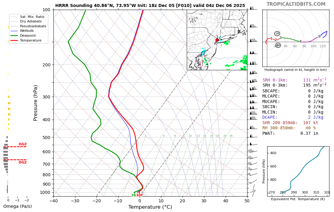
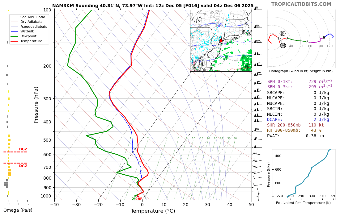
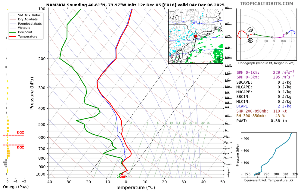
Saturation is below the snow growth zone. The moisture is very shallow. That's probably snow grains and/or ZR. Not impossible a few spots get lucky if lift/saturation is more robust than modeled... seems doubtful for now.
-
The low level moisture moving in on a SSE flow is already visible on radar off the NJ coast. If it's ZR, I can see short-fused advisories being posted. I hope it's snow/snow grains instead.
-
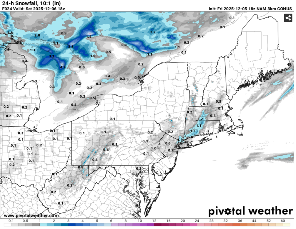
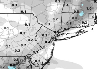
The 18z 3km NAM has 0.1" liquid for part of the region tonight. I'm skeptical that it can accumulate much due to snow growth problem. But sometimes these low level lift/crystallization events that linger for several hours over an area can surprise. I'll take the under for now.

-
-
Examining model soundings for tonight, it looks like saturation is mostly below the snow growth zone. That suggests maybe freezing drizzle and snow grains.
-
Cycling through all model guidance from 0z to 12z it's kind of funny to see what looks like a snow force field in effect for our area. Plenty of action but it's either north or south. Hope it changes soon.
-
The GFS is an outlier with respect to Sun-Mon. There is very little overlap between the EPS/GEPS and the GEFS right now. But... the GFS has trended "better" for a few runs now. Negatives are north SLP track and southerly winds, positives are decent antecedent airmass and potent shortwave.
-
The RGEM snow accumulation map I showed in now through Saturday. I should have showed the time stamp and duration. There's a weak mid-level shortwave interacting with the offshore SLP. It could generate snow showers on Saturday. I agree that the Friday and Sunday events are frustration.
-
The RGEM has a little snow early Saturday. It's not much and it will probably shift east or be flurries if it's even real, but it's something...
-
I read Albany airport is over 14" already this season and they average 3.9" to date. That's a heck of a start! The valley can be a bit of a snow hole with substantially more snow to the east and west. There are indications it might continue for a while. Enjoy it up there.
-
I remember many winters back through the 90s where there was bare ground through Xmas/New Years even up into the North Country and Vermont... sometimes even in the heart of winter, especially outside the mountains. So far this year it's deep winter throughout the interior. That could be a harbinger of things to come. There's been a bit of a screw zone relative to climo over the past few years from EPA through NENJ and SENY while places north, east, and south have cashed in occasionally. That experience can create a negative bias with respect to future outcomes. But eventually our luck will change despite the warming global climate.
-
Random observation, but it's been a snowy week in Albany and the upper Hudson Valley. Yes that's far outside our region, but not typically a very snowy area. They got into intense lake effect snow last Fri for several hours then warning snows on Tue and now arctic snow squalls incoming. Hopefully we can spread that love a little further south down the Hudson over the next few weeks.
-
IMO you have been traumatized by repeated cycles of expectation/hype followed by failure/disappointment. Those "patterns" you speak of were imaginary constructs created by weather hobbyists in an era of 4 times per day models run out to 16 days. Models and certainly meteorologists cannot accurately predict regional weather out past 10 days. So don't be fooled. In the 90s we had a handful of short range models out to 2 or 3 days and a handful of medium range models out to 5 or 7 days. They ran twice a day. People didn't pretend to "see" favorable patterns way out in fantasy range. And hobbyists weren't therefore disappointed by not realizing the imagined potential. It is always hard to get snowstorms near NYC. A lot has to go right for it to happen.
-
The 12z GFS has shifted a little south and sharper aloft for the Sun-Mon clipper. Looks pretty nice for CNY and NE. Even gets some snow into or close to the City. The shortwave track is pretty far north but the 12z GFS is closest yet to something interesting in that time period. The GFS is not entirely on its own either.
-
Snow squall warnings currently posted in parts of CNY and NPA. The squalls probably won't hold together as the front slides southward through our area, but there's a small chance.
-
Thinking Decembers of old were so much colder and snowier is a classic example of rosy retrospection. Yes it used to be colder. If you're 120 years old you might just barely remember when they used to harvest thick blocks of ice on Rockland Lake near Nyack. And yes, we haven't had any huge snowstorms over the past few winters. But as of December 4, this has been a pretty typical fall and winter. We haven't had any major warmups and there are none currently on mid-range guidance. It will be cold enough to snow for much of the next week (as currently modeled) and if we get a little luck, it just might snow. NYC doesn't average a ton of snow in December. The 70s, 80s, and 90s did not feature a lot of snowy Decembers.
-
Most guidance shifted east with the notoriously fickle inverted trof for Saturday. Can't rule out flurries or snow showers now through Saturday but hard to envision any accumulation ATM. Medium-range models show a parade of potential "threats" but nothing tangible yet. The longwave flow is broadly supportive of wintry threats. The Sun-Mon clipper is first up. Feels like winter... especially in areas with a little snow cover (not far NW of NYC as seen on satellite).
-
A few more models are picking up possible snow showers tomorrow. The norlun feature on Saturday is also picking up a little more support. I think either feature could surprise with an isolated C-1"... I think there's even a low chance (maybe <1 in 8) of someone picking up 2" on Saturday in a persistent band. Unlikely though but still fun to nowcast if it happens.
-
There could be flakes in the air on Thurs, Fri, and/or Sat from 3 different mechanisms. After the arctic front passes on Thurs, it should be cold enough everywhere. If the ground gets dusted white you will feel better about winter. The Sat. shortwave probably will only trigger flurries, but it's well positioned with a weak offshore SLP to potentially initiate an inverted trof (norlun) especially for eastern areas/SNE.
-
Unfortunate wave timing on the models right now. The southern stream shortwaves for Friday and Sunday are perfectly timed with a northern stream shortwave to suppress the flow out ahead of them and prevent amplification. On the GFS, the subsequent wave on Wednesday instead has a little ridging in the northern stream out ahead of it and easily amplifies into a cutter. We should avoid simplistic black and white statements like the Pacific is somehow preventing snowstorms. For each of the next several waves, a subtle and random shift in the height field could or could have allowed snow for us. We've always had wave interference. It's why it doesn't snow every week in our region. This is our climo. When the pieces fit together, it will snow. Same as it's always been.
-
6z ECM has 0.10 to 0.15 liquid on Friday for our area. Not much support. The Canadian/GEPS shows a weak Norlun signature on Sat. morning. Weak overrunning can sometimes trigger precipitation much further north than anticipated... but virga is the likely result.
-
0z ECM gets about 1" of snow up to NYC on Friday evening. It looks cold enough to accumulate most areas if snow does make it that far north. Not much support at this point, however. The ECM is the northern outlier.
-
FWIW, you only had to go about 30 miles north of NYC today to find good snow. It never got above freezing in most of Putnam County, NY including all the way down at river/sea level. This was a cold airmass for that area (before, during, and after), which isn't typically a snowy location. New England got kind of boned with this storm because of the particular upper level progression and low level flow/coastal fronts. But this was kind of a fluke.
-
I like your hint of optimism. The modeled longwave trof position and angle look very favorable for almost 10 days. Wave after wave diving from the Pac NW into the central US... just need one or two to find a gap and amplify. I think it's the kind of "pattern" that you'd want in December to try to string a few together and build a pack. Odds are usually against us, but I don't hate the look.
-
Seems like there's plenty to track if you like model watching. There's a chance of snow showers or maybe even squalls on Thursday with an arctic front then an outside chance of light snow friday and then basically a trackable wave every two days thereafter. It also looks cold at least through early next week. No slam dunks but this winter feels different so far than the past few. Snowstorm are always uncommon in these parts so we'll take what we can get.