eduggs
-
Posts
5,950 -
Joined
-
Last visited
Content Type
Profiles
Blogs
Forums
American Weather
Media Demo
Store
Gallery
Everything posted by eduggs
-
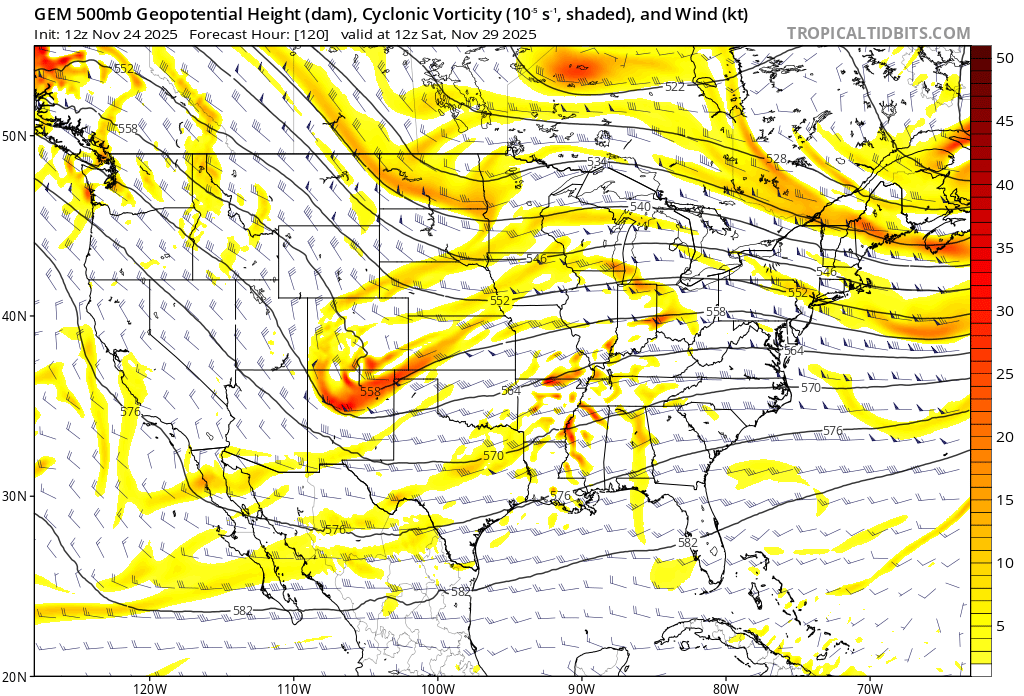
The surface features aren't driving this outcome. The position and strength of the surface highs and lows follow the upper levels. The trend over the past 2 days is for the shortwave to not "dig" as far south. The vortmax that passes through the Great Lakes is becoming increasingly prominent. The path of this shortwave and vorticity advection ends up tracking pretty similarly to Sunday's wave that precedes it. That leads to a stronger surface reflection (primary) near Western PA and southeasterly low level flow that quickly changes snow to rain along the coastal plain. The hope is that maybe guidance is keying on the wrong packet of vorticity and that the models will shift back towards a more favorable trof evolution. As of now this is transitioning towards a SWFE-type event that favors the interior, particularly New England. But it's still close to a wintry outcome... and highly trackable.
-
I'd like to see a sharper trof like last night's GFS and UK. That allows more intense and widespread precipitation and it also anchors the surface high further west in Quebec due to the strongest upper level convergence staying further west. With a more positively tilted trof, the surface convergence shifts east and the surface high goes with it. (upper levels and surface are connected in the sense that converging air aloft tends to sink [surface high pressure] and diverging air aloft tends to rise [surface low pressure])
-
The GFS lost the big western trof and sharpened a different shortwave in the central US in just a few cycles. This happened in the mid-range, not fantasy range. It just goes to show how variable model output can be in this range.

-
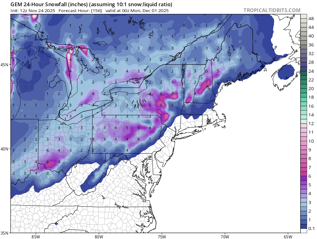
GEFS, EPS, and GEPS members clustered where we'd want them I think, mostly offshore with the SLP. Hints of a weak primary up the Apps. The bulk of the precipitation along the coastal plain. Surface temperatures for low elevation coastal areas are marginal for snow and the real cold doesn't move in until the storm is departing. But that's a pretty good look overall for a 6 day forecast. The bar for me at this point of the season is a shovelable snowfall. I don't want to get carried away by 10:1 snow maps.
-
0z GEFS is slightly drier/south compared to 18z. So the GFS and GEFS moved towards each other this run.
-
The GFS retrogrades the CA ULL west into the Pacific. If that doesn't happen, the longwave flow across the US would be significantly altered. Our downstream weather is extremely sensitive to the modeled evolution of the western trof over this period. Could still end up balls cold or periodically torched days 6-15.
-
The 0z GFS is an absolutely filthy glutton for snow. I'm going to pretend I didn't see the extended run and keep my personal focus on the mid-range.
-
The UK is also an excellent run at 0z (both surface and aloft). Supports the GFS - maybe slightly better even.
-
Can't complain about the 0z GFS. We haven't had a widespread coastal snowstorm like that in a while. Gorgeous ouput! CMC, ICON, ECM, and ensembles close enough for interest. Hopefully no big swings from here on out (doubtful)... Small, incremental improvements would be ideal. We are still almost a week out, so it's still going to be tough to pull this off I think.
-
The last two GFS op runs are well east of the GEFS mean days 5 through 6 with the shortwave and SLP in the east. The GEFS mean shows precipitation primarily in the lower MS valley while the op GFS shows it along and off the east coast. Discounting the op runs for now though an eastward trend is noted in the other mid-range op models. The GEFS seem to be somewhat of a compromise between the 12z EPS and GEPS. The GEFS would put us right on the edge of both significant precipitation and marginal temperatures for wintry precipitation.
-
I'm still in the warm/wet or cold/dry camp, for now. I agree that chances are next week won't work out along the coastal plain. But no two snow events are exactly alike. This period could work out, so we track.
-
So I guess we have our first definitive threat period Dec. 2-3. All mid-range modeling indicating at least the threat of a wintry storm. Still highly variable setup so I'll try to keep my enthusiasm in check. Of note, the GEFS have backed off the past few runs but that brings us closer to a model consensus.
-
All guidance appears to be "struggling" with the amplitude of shortwaves coming down the ridge from AK to CA. This is an area where minor perturbations grow into mature trofs or deep upper lows. It may or may not also be a data sparse region. This is leading to huge intra-and inter-model variability with respect to west coast trofs, their amplitude, and which is dominant.
-
Check out this discontinuity between 0z and 06z on the GFS. That's day 5.
-
Pretty sick GFS run! Wow. The CMC is going to be a little warmer, but close-ish. The key difference is the high pressure nosing down reflecting the slightly more suppressive mid-upper level flow over New England. Here's to hoping the models home in from here instead of wild swings.
-
I'm rooting for this day 5 shortwave on the CMC. It gets closest to a wintry outcome in the mid-range. I always root for mid-range instead of long-range fantasy-land. There's not much support on the ensembles, unfortunately. The ICON and UKMET might get a few flakes to the area, but everything is north and/or weak. I don't even want to consider day 10+. Too unreliable.

-
I haven't looked at the UKMET in a while. The 0z is also significantly divergent from the (hideous) GFS as early as day 5 and pretty cold at the end of its 7 day run. It actually tries to get some snow into our area on Sunday with the weak in-between shortwave. Other guidance has this feature very weak or further north. I'm happy with any model run that doesn't send repeated cutoffs to CA. I'd love to see the ECM and EC-AI move away from the southwest cutoff at 0z.
-
At 12z the CMC and GFS were in decent agreement all the way out to day 7. Now at 0z they suddenly diverge pretty significantly as early as day 5. They've kind of switched places with the GFS suddenly much deeper and further southwest with a mature ULL meandering through CA and the CMC moving away from that look towards a more positively tilted and further east trof. The take home message is that this is a period of high model volatility. It probably doesn't matter much because either way we're too far from the cold air (through the mid-range) until the moisture is gone. I prefer the CMC look, however. It keeps us a little closer to the goods. I despise the deep ULLs burying themselves in CA , which are really hurting our chances.
-
November 2025 general discussions and probable topic derailings ...
eduggs replied to Typhoon Tip's topic in New England
The 12z ECM and 18z GFS (with support from the EPS/GEFS) show what we fear along the coastal plain. It's a classic cool/rain to cold/dry and then repeat scenario. That's not unexpected or unseasonable for this time of year. But it's been a nuisance for a few years now, including in the heart of winter. So it would be nice to get a complete breakdown of that repetitive sequence inside 7 days. We've had way way too much rain in recent winters. If a more favorable longwave pattern is always out beyond 10 days, it's just a tease. -
There's very little support on any of the major ensembles for much snow through 10 days... or even 12 days (corrected, the GEFS shows the Dec 4/5 potential wintry event). It looks relatively active with cold air not too far away, but the multi-guidance consensus suggests the progression and evolution of the longwave pattern is not locally favorable. Even the individual members are stingy with wintry outcomes for the moment. Early December is still highly trackable... and we know that ensemble members group too close to the parent model, so favorable changes are still possible especially out past 7 days.
-
On the 12z GFS, we are closer to the cold side of the strong thermal boundary modeled to set up in early December. I expect this boundary to nose southward and affect the north country, but it could potentially push even further south. I'd rather see weaker waves eject northeastward and slowly decay instead of consolidated ULLs pumping the east coast ridge. We could really use some well-timed suppression. The subtle upper level interactions will have huge implications on surface weather over this holiday period and beyond.
-
If we can get the thermal boundary to be squashed far enough south we might at least be able to begin with some wintry precipitation out ahead of any overrunning system around 11/30 (Thanksgiving weekend). The ICON and now GFS have been hinting at this scenario. The 0z CMC and ECM had a less defined mid-level shortwave (~day 6) between the prominent systems, but the EC-AI is somewhat supportive. This looks volatile in the modeling as there are strong waves upstream and downstream that will likely lead to major run-to-run changes. But I think there is a small hint of a pathway to something wintry before fantasy-range.
-
November 2025 general discussions and probable topic derailings ...
eduggs replied to Typhoon Tip's topic in New England
I agree that IF/WHEN there is a meaningful snow event in SNE, it will likely happen beyond day 10. I think that because there is broad agreement between the GEPS, GEFS, and EPS of no big threat before then. I don't think that because of anything visible in the longer-range. There is still some room to sneak in something wintry before then... e.g., the weak wave over the center of the US on the GFS at day 6 could evolve into something more... or numerous other very minor threats... but none are likely based on the current ensemble spreads. -
November 2025 general discussions and probable topic derailings ...
eduggs replied to Typhoon Tip's topic in New England
That's an ad hominem. I've been posting about New England weather longer than you have. Where I live (which happens to be very geographically close to your home state), is irrelevant. If you disagree with something I wrote than say so. -
For regional weather forecasting, beyond 10 days has low predictive utility, even on the ensemble means. And we don't even have anything favorable within that time period yet. Right now we are looking at mostly a storm track to our west with cold snaps on the wake of storms. That's within seasonal norms. If we get a cold and snowy look inside day 10 on multiple ensembles, it's a plausible outcome. Inside day 7 and it's worth getting a little excited about. But IMO, anything outside of that range is fantasy range territory.