

eduggs
-
Posts
5,950 -
Joined
-
Last visited
Content Type
Profiles
Blogs
Forums
American Weather
Media Demo
Store
Gallery
Everything posted by eduggs
-
I'm with you. I think there will be a decent swath of accumulating snow overnight tonight. I just personally think the 12z HRRR was too "wet" into the cold/dry air and a little too far north with the axis. It also keeps measurable precipitation going further east into NYS and CT. That might be suspect based on other guidance drying things out quicker. The 18z is a little drier and maybe a hair south of 12z. I think it has been incrementally shifting towards model consensus. The 18z RRFS also looks a touch drier and more reasonable to me. The GFS and CMC have likely been too far south and late to correct. The best bet for accumulating snows looks to be in PA right now. But we've seen cases before where banding unexpectedly extended accumulating snows eastward as a shortwave decayed into the residual cold of a longwave trof. The radar will be interesting late tonight.
-
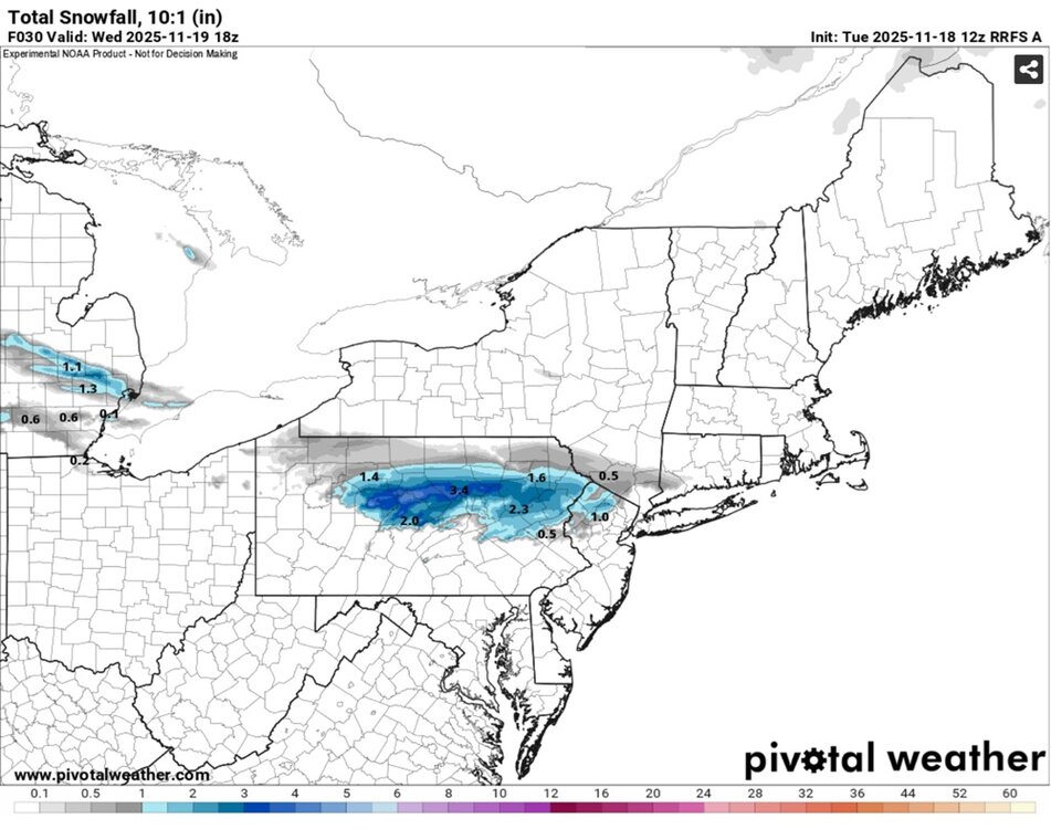
Here's the 12z RRFS snowfall output at 10:1 for our area. I think the CPA ridges are going to get a solid coating. But it dies out pretty quickly as you move eastward towards our area.
-
I generally hate posting fantasy model snow maps, but I couldn't resist this one. Here's the 12z HRRR. This is far outside the inter-model spread, so extremely unlikely. It's certainly not close to what I expect to play out. But it made me smile to see anyway. The HRRR has been backing off every cycle since.
-
Just about every 0z model shows some snow or rain/snow mix for parts of EPA through Warren, Sussex, and Morris counties in NJ overnight Tuesday into Wednesday. It's mostly a narrow strip at the northern edge of a decaying precipitation shield, but a few models mix in some snow across a wider area. It's an overnight deal that most won't even notice and it's certainly not a sexy storm. The other problem is surface temperatures in the mid-30s. But I believe there's a chance for an inch or two of snow in a few spots above 1000ft along the northern edge of the steady light precipitation. That's more likely to occur in CPA, but if it holds together long enough, parts of NJ might be in play. The NAM looks overdone but RGEM/GFS/ECM/ICON look plausible. Note the images show 10:1 snow accumulation even though actual accumulations are unlikely in lower elevations due to surface temperatures. 0z NAM 0z RGEM
-
I'm not one to argue that climate change isn't having an impact. On the contrary, I believe the regional climate has warmed so significantly that its effects have clearly bled into observable weather statistics. But just to play devil's advocate regarding Saranac Lake this year... anecdotally it has been a windy, cloudy November up there. The coldest airmasses have not been accompanied by calm, dry conditions. I suspect that somewhat unfavorable conditions for radiational cooling in the Adirondacks thus far this fall are superimposed on a relatively warm background.
-
Maybe a period of light snow on Tuesday night with an outside chance of minor accumulations in elevated spots of NNJ, NEPA, or SENY? There's been a slow and gradual trend towards higher QPF over the past few days on most of the mid-range models and with overnight timing and a marginal antecedent airmass, it's not out of the question. The shortwave is dampening, but once in a while these end up more robust than modeled.
-
November 2025 general discussions and probable topic derailings ...
eduggs replied to Typhoon Tip's topic in New England
This is an example of "progress blindness" with underlying aspects of negativity bias, availability heuristic, and confirmation bias. Long-range ensembles have never been as reliable as they are now. At the same time, they are not now and never previously have been particularly useful for sub-continental-scale pattern forecasting beyond day 10. -
There is a significant lag between an increase in global atmospheric CO2 & CH4 concentrations and an increase in mean continental surface atmospheric temperature. Most data sources show global temperature increased most significantly after about 1920. In the US, there appears to have been mean warming in the early part of the 20th century, following by cooling through ~ the 1970s, followed by the period of pronounced warming that we're in. The 1930s were warmer than parts of earlier centuries for sure. This was likely the result of a combination of astronomical and anthropogenic climate factors. The rate and magnitude of current warming is much more significant than previously observed during historical times. The data that bluewave showed does suggest that low snow years in the 1930s were more related to total precipitation than to temperature compared to the present. Though temperature in the 1930s was likely more of a factor than during the 18th or early 19th centuries. And I suspect persistent under-measurement of snowfall was also a factor.
-
Graupel shower. Ground whitened. 47F
-
The 4" number is arbitrary and/or coincidental. It is way over the top to claim that threshold is "required." If there is or was a meaningful causal relationship between December & winter snowfall at a particular reporting station, the causal factors have probably become less meaningful in the modern warming climate regime. This statistical connection is much more likely to represent merely a historical correlation than a causally predictive metric. There are likely too many confounding factors and too small a sample size for such a statistic to be meaningful. Snowfall is a very local phenomenon. Just a few miles can separate significant snow from flurries or rain. And the way snow is measured has changed over time. Maybe a novice statistician or a superstitious hobbyist would take this seriously. But I suspect others would rightly poke holes. When we have 1000 winter season to adequately power an analysis, we can revisit this argument.
-
Great snow squall in West Point and Garrison, NY. Most surfaces briefly snow covered. Might have been half an inch in a few grassy spots before quickly melting.
-
Still looks good for flurries and maybe scattered snow showers on Tuesday! But the mid and early-long range look a little less interesting today.
-
This upcoming week should include both first trackable flakes and first long range trackable but unlikely wintry threat. These are fun seasonal milestones to achieve... Nicely covered by the previous posts. I'm looking forward to some webcams and images from Chicago later tonight.
-
November 2025 general discussions and probable topic derailings ...
eduggs replied to Typhoon Tip's topic in New England
Now using facts, the scientific method, and reason are "leftist?" When did that happen? -
Agree with Walt D. about the possibility of first flakes in the 11/10 - 11/12 period. The GFS, EC, CMC, and ICON show a few different possible scenarios to achieve it. Parts of the mid-Atl may even be favored to get flakes before us. There should be some steep lapse rates and hopefully snow showers if an ULL swings through (ECM/ICON) and/or in the cold northwest flow that develops behind the rain event (GFS).
-
Yeah. And I wouldn't ever expect wall to wall cold in November. The mean jet is historically to our north and its undulations deliver alternating cool and warm shots. But in a warming climate regime, I'm happy for every seasonal cold shot we get.
-
Inter-model guidance still showing a nice cool shot around Nov. 10-12. We'll see if it holds.
-
Most snow lovers want snow whenever they can get it. Winter-season snow sticks around longer and holiday snow enhances the season. So we'd choose those scenarios if given a trade option. But it doesn't work that way. Any apparent correlation between early season snow and winter snow is likely coincidental and skewed by a small sample size.
-
I agree that a wintry coastal storm is unlikely. But I think your MSLP graphic at 198hrs is misleading. First, it's a snapshot in time at long range. And second, at first glance the color schemes resemble height anomalies, which is confusing. The ensemble averaging effect almost always produces noticeable differences between an individual operational run and its ensemble average at that time range. But to my eye, the op and ensembles are in reasonably good agreement with some kind of cold wave centered around the 10th. To argue otherwise seems somewhat disingenuous. But if the intent is to merely downplay the likelihood of accumulating snow from a coastal storm at the coast, I completely agree. But I don't think you need to label the op run as an outlier to make that point. The 1009mb off the Delaarva at 192hr on the 12z GFS is 12 hours earlier than a cluster of SLPs associated with the shortwave on the individual ensembles. But the broad representation is consistent.
-
With respect to the GFS op vs. the GEFS... it's mostly a timing issue. The op is has a higher amplitude trof with a deeper SLP and slower progression. Such a difference is typical at that time range. That's why we generally disregard specific local weather outcomes at that range. But the signal and progression of the GFS op is similar to its ensembles.
-
The EC-AI is cold in the long range... probably too cold. 1000-500mb thicknesses are near or below 540dm from Nov 9 through the end of the run. They bottom out near 510dm! The GFS, CMC, and their ensembles have a solid cold "signal" too. Nothing historic or severe... but definitely wintry-precip-supporting cold. I feel like these modeled cold snaps usually moderate in time. I'm be curious to see how well it holds through the coming week.
-
ICON has the Nov 10 threat too. I will almost always "sell" a wintry threat near the coast this early in the season unless it's modeled in the short term. But what I'm happy to see on guidance is maybe the first decent Canadian-cold delivery of the early season. If wave timing is ideal, it's the kind of scenario that could whiten elevated NEPA, southern tier of NY, Catskills, Berks etc.
-
EPS, GEFS, and GEPS all have a semblance of a wintry threat centered on November 10, plus or minus a day. It's been there for a few cycles now. All the usual caveats apply. Far inland, elevated spots look to have a decent chance of flakes over the next 10 days or so. That seems fairly consistent with historical norms.
-
I think there's an issue regarding how "major flooding" is defined. If a road is inundated that doesn't normally flood, it's hard not to describe that as major flooding. But that doesn't necessarily match up with USGS statistical data and graphics. Although I'm not sure how minor, moderate, and major coastal flooding are defined.
- 731 replies
-
- 1
-

-
- heavy rain
- damaging wind
- (and 2 more)
-
From what I can see from the hydrological stations in and around new york harbor, this afternoon's high tide has crested slightly below yesterday's predictions. That's a good thing for people on the immediate shoreline, but there's still widespread minor to isolated moderate coastal flooding ongoing.
- 731 replies
-
- 1
-
-
- heavy rain
- damaging wind
- (and 2 more)


