Chicago Storm
-
Posts
19,240 -
Joined
-
Last visited
Content Type
Profiles
Blogs
Forums
American Weather
Media Demo
Store
Gallery
Everything posted by Chicago Storm
-

March 24-25 Palm Killer (Snow Event)
Chicago Storm replied to hardypalmguy's topic in Lakes/Ohio Valley
There’s been a good bit of TSSN around the QC over the past hour. . -
2023 Short/Medium Range Severe Weather Discussion
Chicago Storm replied to Chicago Storm's topic in Lakes/Ohio Valley
There were a few this evening and tonight. The Rolling Fork-Silver City, MS one was during the evening, and it sounds and looks like it was quite significant. Then tonight Amory, MS took a hit from another significant one. One of the better looking radar couplets you’ll see… . -
For those in MN/WI/MI that are not socked in clouds, a big northern lights display is currently underway. Being reported as far south as Virginia, with solid naked eye viewing.
-
March 24-25 Palm Killer (Snow Event)
Chicago Storm replied to hardypalmguy's topic in Lakes/Ohio Valley
it's a change of pace from the usual spiral into historic michigan snow chat like every other thread. -
I was down in the St. Pete Beach area for a brief trip this past weekend (Sat-Mon). Typical winter/spring transition weather down there during my short stay.
-
March 24-25 Palm Killer (Snow Event)
Chicago Storm replied to hardypalmguy's topic in Lakes/Ohio Valley
I was down that way (SPB) this past weekend. Red tide wasn't an issue this past weekend, at least. Sounds like main effects have been further south along the coast. -
March 24-25 Palm Killer (Snow Event)
Chicago Storm replied to hardypalmguy's topic in Lakes/Ohio Valley
this may be your worst take ever. -
Downtown/lakefront is easily under 10” on the season.
-
Drought is definitely not going to be a concern for most, for a while that is.
-
Spring 2023 Medium/Long Range Discussion
Chicago Storm replied to Chicago Storm's topic in Lakes/Ohio Valley
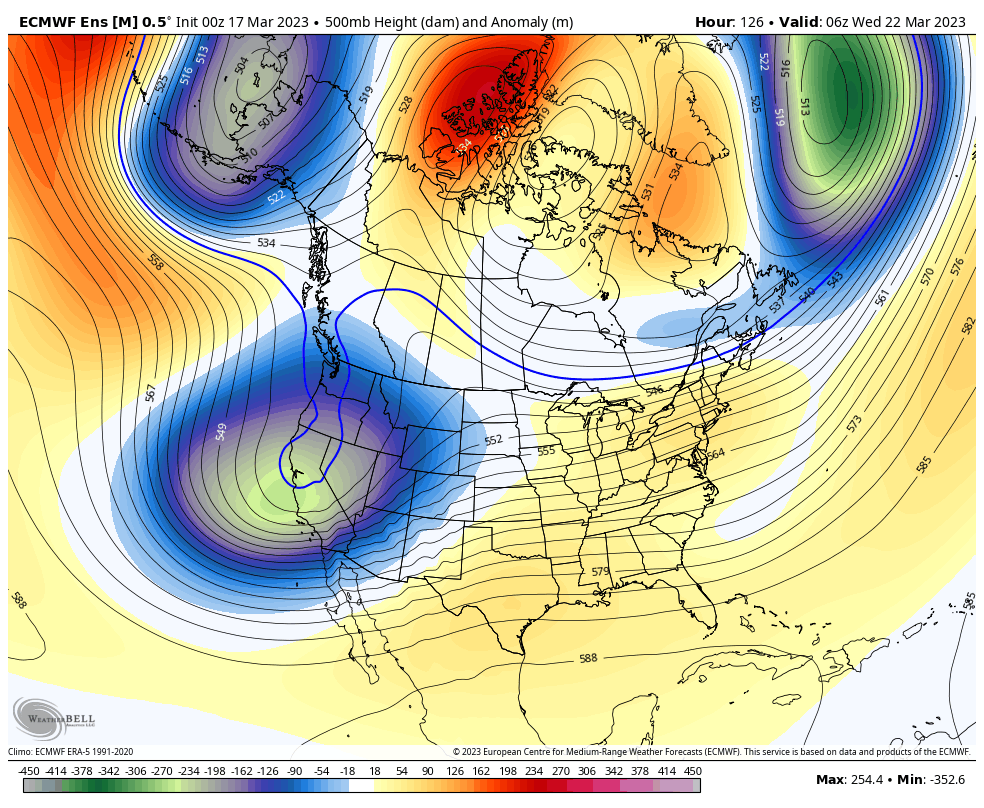
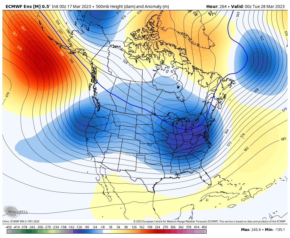
The first 1/2 of March pretty much went as expected for the most part. The second 1/2 of March, which we have already moved into, will feature a very rollercoaster March-like weather pattern across the CONUS. As mentioned in the previous post at the start of March, the pattern was already expected to be once again transitioning by now, which it has done so. The period of significant -EPO/-AO/-NAO has quickly relaxed, giving way to an EPO/AO/NAO that is in flux, and will continue to be through the end of the month. What this means is we will see periods of AO/NAO ridging, pretty much transient or meandering nature, but nonetheless still there. With an EPO bouncing around the +/- sides of neutral and a significant/lengthy -PNA period expected, this will support constant troughs dropping in from the Alaska vicinity, down into the West Coast, and then moving across the CONUS below the transient AO/NAO ridging. This will all lead to an active, but steadily moving weather pattern across the CONUS. Best snow chances will be across the northern half of the sub-forum, namely the heavy hit corridor of the winter (MN/WI/MI), with severe weather opportunities possible across the southern half of the sub-forum. This will also be a pattern with temperatures that bounce around quite rollercoaster like as well, with mild temps ahead of storm systems and cool temps behind them. Once again, all in all what I would consider to be a typical March-like pattern. Looking ahead towards getting into the beginning of April, it looks quite likely a similar pattern will continue.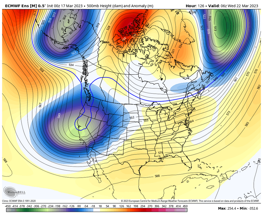

- 431 replies
-
- 10
-

-

-
new season, same disco.
-
dab is <1".
-
There seems to be a discrepancy between what's being reported. Sunday evening when the latest storm was winding down, snow depth was 50"...but 12 hours later at 12z yesterday morning it was "only" 37.
-
Spring 2023 Medium/Long Range Discussion
Chicago Storm replied to Chicago Storm's topic in Lakes/Ohio Valley
your show has run it's course. -
Snowfall totals from around the area... 0.4" ORD 1.5" MDW 3.4" RFD Might add a bit more between today and tomorrow, with additional scattered snow showers. .
-
-SN started about an hour ago here at home, with what looks like a non-measurable dusting thus far. .
-
cromartie roped in another one, with 10-12" reports in the area.
-
Final storm snowfall totals from around the area... 1.2" ORD 0.5" MDW 7.4" RFD
-
Two issues though... For one, widespread warning criteria snowfall amounts did not occur in Lake or Northern Cook counties. Those type of amounts did occur in Northern Ogle, Winnebago, Boone and McHenry counties though. However, that sort of outcome for much of that corridor had very little in the way of support going into the event. As we all know, higher corridors often do occur, as do 'screw zone' corridors. As much as I tend to hate on the NWS at times (More-so the SPC), their headlines were perfectly fine in the LOT CWA.
-
Snowfall totals of 1.2” at ORD, 0.5” at MDW and 7.3” at RFD as of 6AM. .
-
We're well into March now, so it's about time...
-
It's more along the lines of an (Ensemble) forecast system.
-
I’m able to replicate the issue.
-
Snowfall totals of 0.3" at ORD and 6.8" at RFD as of midnight. SNINCR at ORD during the midnight hour, so somewhere near 1" total snowfall now. KORD 100651Z 06007KT 1SM R10L/P6000FT -SN BR OVC004 01/M01 A2997 RMK AO2 SLP156 SNINCR 1/1 P0007 T00061011
-
Recently flipped back to all snow, and probably for good. We’ll see if anything ends up accumulating. .