

Chicago Storm
-
Posts
19,240 -
Joined
-
Last visited
Content Type
Profiles
Blogs
Forums
American Weather
Media Demo
Store
Gallery
Everything posted by Chicago Storm
-

2023 Short/Medium Range Severe Weather Discussion
Chicago Storm replied to Chicago Storm's topic in Lakes/Ohio Valley
Since moving down here in November 2020, this will be the 4th tornado within 15 minutes of home. -
2023 Short/Medium Range Severe Weather Discussion
Chicago Storm replied to Chicago Storm's topic in Lakes/Ohio Valley
A brief clip of the circulation as it passed within my view off of my balcony. -
2023 Short/Medium Range Severe Weather Discussion
Chicago Storm replied to Chicago Storm's topic in Lakes/Ohio Valley
The rotation/couplet that prompted the tornado warning in DuPage Co earlier this morning passed just across from home. Looks like it may have briefly touched down once or twice, with a bit of minor/sporadic tree damage down the road. . -
stevo trying to comment like he knows anything is lol. .
-
2023 Short/Medium Range Severe Weather Discussion
Chicago Storm replied to Chicago Storm's topic in Lakes/Ohio Valley
0-3km cape magic. . -
Winter 2022/23 Short/Medium Range Discussion
Chicago Storm replied to Chicago Storm's topic in Lakes/Ohio Valley
Final snowfall total of 1.7” at ORD. . -
Winter 2022/23 Short/Medium Range Discussion
Chicago Storm replied to Chicago Storm's topic in Lakes/Ohio Valley
1.3" to be exact. KORD 250351Z 11003KT 3/4SM R10L/3000VP6000FT -SN BR BKN008 OVC018 M04/M07 A3049 RMK AO2 SLP335 SNINCR 1/1 P0004 T10441067 -
Winter 2022/23 Short/Medium Range Discussion
Chicago Storm replied to Chicago Storm's topic in Lakes/Ohio Valley
Yea, it's coming down here. Will measure shortly for the hourly, but likely will have near 1" just eyeballing it right now -
Winter 2022/23 Short/Medium Range Discussion
Chicago Storm replied to Chicago Storm's topic in Lakes/Ohio Valley
Weak disturbance moving through tonight, with an f-gen band of snow shifting NE through the area this evening. Already dusted here at ORD with -SN. -
Winter 2022/23 Medium/Long Range Discussion
Chicago Storm replied to Chicago Storm's topic in Lakes/Ohio Valley
Sorry to break it to them, but they're like 2 weeks behind on that. Already happened. -
it's 80 in D.C. today, they've had 18 60+days this winter, and they have 0.4" of snow on the season. perfection.
-
Chicago Weather Records Tracking
Chicago Storm replied to Chicago Storm's topic in Lakes/Ohio Valley
ORD received 1.20" of rainfall yesterday, which broke the record precipitation total for the date of 0.95", which was set in 1919. -
After leaving ORD last night, I took a drive NW towards the old stomping grounds of ex-home in NW Cook Co. The cut off between ice/no ice, as @kevlon62mentioned yesterday, was indeed right along I-290...and it was very sharp. It was the type of gradient where if you were on a given road, trees on one side were ice covered and the other side were not. Carrying on into the vicinity of Schaumburg/Streamwood/Hanover Park in NW Cook Co, there were widespread power outages and widespread tree damage as well. It reminded me of how things look in a post widespread damaging wind producing severe t'storm event in the warm season. I measured just shy of 0.20" of ice still on the trees at that time, and that was after several hours of melting at that point. So at the peak, there was likely ice accumulation of 1/4" around that area.
-
ASOS storm total ice accumulation in the area… DPA - 0.39” RFD - 0.37” UGN - 0.33” *Sensor outage, not a complete total. PWK - 0.17” Final rainfall totals in the area… ORD - 1.20" *Record for the date (0.95" - 1919). MDW - Sensor outage. RFD - 0.95"
-
687k without power in MI, and much of that in S MI. N IL peaked at 115k. .
-
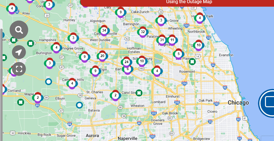
Closing in on 100k without power across N IL.
-
some are not as far away as you think.
-
Power outages rapidly increasing across N IL. You don't even need to look at the radar, you can just look at the outage map to see where there has/hasn't been ice.
-
he stays on point.
-
Based on pictures I've seen, even with borderline temps and heavy rates, ice accrual has been fairly efficient across portions of Northern Illinois.
-
some of you need to take a page out of cromartie's book. every time he talks up a mild pattern and morch, he gets a solid snowfall.
- 875 replies
-
- 11
-

-

-
Winter 2022/23 Medium/Long Range Discussion
Chicago Storm replied to Chicago Storm's topic in Lakes/Ohio Valley
Active is something we've had going for us more often than not this winter at least. With that continuing, time for repeated hydro issues. -
Winter 2022/23 Medium/Long Range Discussion
Chicago Storm replied to Chicago Storm's topic in Lakes/Ohio Valley
I mean yea, there most definitely will be more opportunity. Whether any of it works out or is interesting enough remains the question. -
ASOS ice accumulation in the area as of 2PM… RFD - 0.22” UGN - 0.22” DPA - 0.21” PWK - 0.09”
-
the lead wave is the main wave here. looking good later, hopefully we can get some t'storms in the area.

