Chicago Storm
-
Posts
19,232 -
Joined
-
Last visited
Content Type
Profiles
Blogs
Forums
American Weather
Media Demo
Store
Gallery
Everything posted by Chicago Storm
-
Added another 1.0" at ORD from 0-6z, for a final storm total of 2.0".
-
Easily the best looking LE on the western half of the lake this winter. .
-
Toss. Main convergence axis is passing downtown right now, and has been steadily shifting east. It's already fully offshore from NE Cook Co up through SE WI.
-
An additional 0.6" of SN/GS/PL accumulation from 18-0z at ORD, for a storm total of 1.0" thus far.
-

-
zzz.
-
Lake enhancement starting to get going across SE WI and NE IL. .
-
Got in to ORD about a half hour ago to find not only has PL dominated precip type, but the RA being reported was actually FZRA for the most part. There's a glaze of ice on colder/elevated surfaces, and several tenths of PL accumulation. During the morning/early afternoon before I got in, precip type has been a mix of SN/PL/FZRA/RA. Since getting in a bit ago, things have transitioned from PL/FZRA to PL to GS and now to -SN.
-
ORD on the board with a SN/PL accumulation total of 0.4" as of noon.
-
Have been flipping back and forth between RA and PL here at home since precip started earlier this morning. Solid dusting of PL.
-
-
Peak wind gust of 55MPH at ORD, with the high winds last evening through this morning.
-
it surprised me too.
-
something is going to happen between tonight and tomorrow night.
-

Winter 2022/23 Medium/Long Range Discussion
Chicago Storm replied to Chicago Storm's topic in Lakes/Ohio Valley
That projected MJO at face value suggests the likely continuation of a mild/active pattern for many, with best cold/snow chances locked up north. However, with the expected continued evolution of the SPV, which will fight back re: pattern, we could be looking at quite an active gradient pattern that fluctuates. A gamblers pattern to the extreme. It's still off in the late February to early March time period, but it is something to watch. -
Winter 2022/23 Medium/Long Range Discussion
Chicago Storm replied to Chicago Storm's topic in Lakes/Ohio Valley
just gonna put this right here...
-
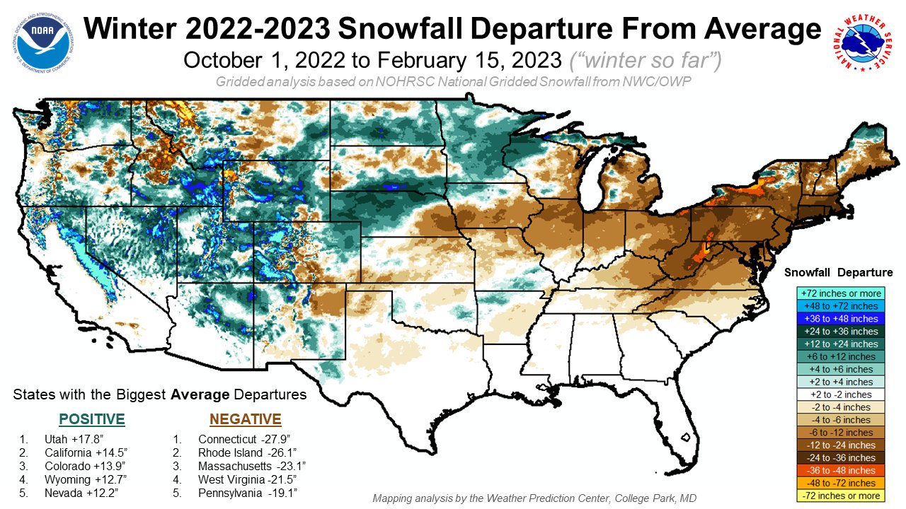
There hasn't really been any pure LES on the SE WI/NE IL side of the lake this winter, and only a few events that have featured some sort of minor enhancement, though none of which actually really aided in producing additional accumulation.
-
we welcome you. .
-
Winter 2022/23 Medium/Long Range Discussion
Chicago Storm replied to Chicago Storm's topic in Lakes/Ohio Valley
not that it matters, but that's not a bowling ball.
-
most ens are weak/se and fairly uneventful, so there's that for ya.
-
the super bowl ending was a disappointment. .
-
Winter 2022/23 Medium/Long Range Discussion
Chicago Storm replied to Chicago Storm's topic in Lakes/Ohio Valley
East will translate to weaker, less phased and more sheared. . -
Winter 2022/23 Medium/Long Range Discussion
Chicago Storm replied to Chicago Storm's topic in Lakes/Ohio Valley
GFS with the fantasy 40-50” blizzard SE of MSP next week. . -
Winter 2022/23 Medium/Long Range Discussion
Chicago Storm replied to Chicago Storm's topic in Lakes/Ohio Valley
pulling for a continued trend nw, to get us into the 60’s and a severe wx op. . -
February 8-9 Should There Be a Thread For This Storm
Chicago Storm replied to Hoosier's topic in Lakes/Ohio Valley
.