Chicago Storm
-
Posts
19,240 -
Joined
-
Last visited
Content Type
Profiles
Blogs
Forums
American Weather
Media Demo
Store
Gallery
Everything posted by Chicago Storm
-

Winter 2022/23 Short/Medium Range Discussion
Chicago Storm replied to Chicago Storm's topic in Lakes/Ohio Valley
you say that, but it’s clear that you don’t. . -
Winter 2022/23 Short/Medium Range Discussion
Chicago Storm replied to Chicago Storm's topic in Lakes/Ohio Valley
if you were far more realistic, maybe that would happen. . -
Winter 2022/23 Medium/Long Range Discussion
Chicago Storm replied to Chicago Storm's topic in Lakes/Ohio Valley
I'd hone in on somewhere in that 15-28th period (And into March). Obviously far out, but that's what the early signals are suggesting. -
Winter 2022/23 Short/Medium Range Discussion
Chicago Storm replied to Chicago Storm's topic in Lakes/Ohio Valley
don’t waste your time. . -
Winter 2022/23 Medium/Long Range Discussion
Chicago Storm replied to Chicago Storm's topic in Lakes/Ohio Valley
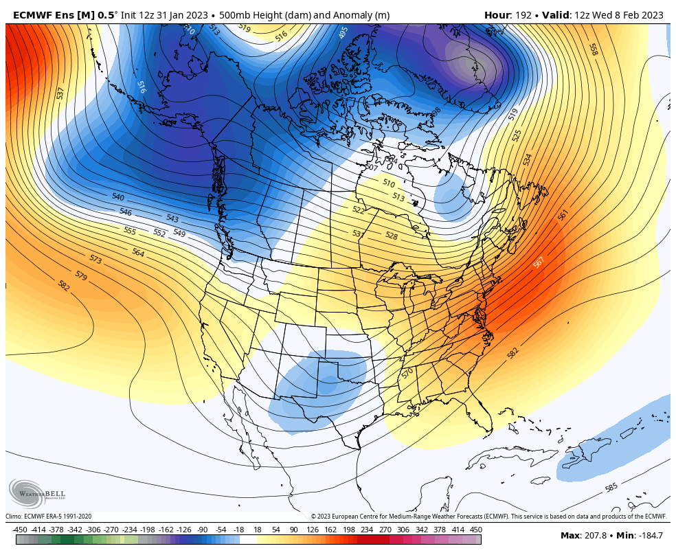
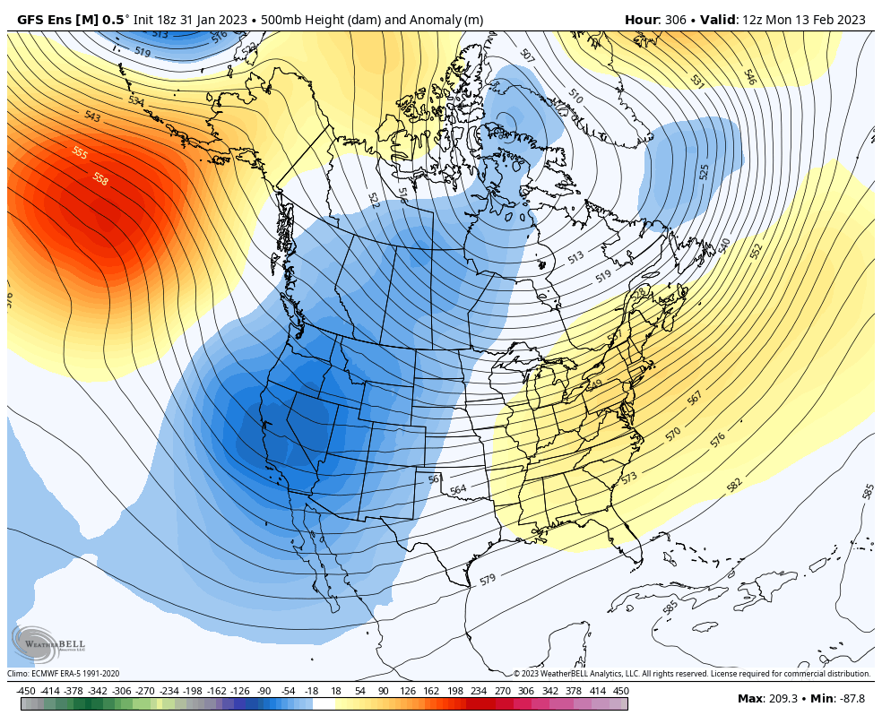
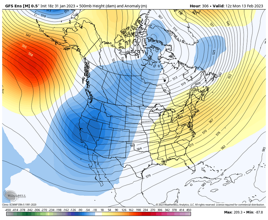
All in all things have gone fairly close to expectation for the final 1/3rd of January. The active pattern continued, which finally brought more widespread snow opportunities to much of the sub-forum. We have also seen temperatures trend colder in stages in the wake of the storm system mid last week. Regarding the current period of the final weekend in January, the shared week of the end of January/beginning of February, and the first weekend of February...The pattern of a relaxing -EPO/-PNA/less -NAO attempts has unfolded, and some aspects have evolved a bit faster than previously depicted when the above quoted post was written nearly two weeks ago. As mention at the time, it would be a gamblers pattern. We obviously had the event this past weekend that some cashed in on quite well and there have been a few minor events to start this week in parts of the Ohio Valley...So the gamble was not a total loss for all, but many left down some some cash. For this first 1/3rd of February as a whole, we will continue evolution to another pattern. We will once again revert back to a less consistent wintery pattern (And less active for a bit in general), one that features the best chance of snow and cold being across MN/WI/MI, and needing to more rely on threading the needle elsewhere. We will see a combination of a NAO hovering around neutral, a +EPO, the PNA around or just south of neutral, the lower atmospheric PV lobe center shifting north and an MJO expected to transition from phase 3 to 4. As we head into the first portion of the middle 1/3rd of February there are some strong signals of wanting to head towards a -EPO/-PNA/big SE ridge pattern. This not only has solid ENS support at this long range, but is also heavily supported by the projected MJO movement as well. However, the one wild card will continue to be the SPV, which continues to be taking hits...and could have hand in altering things in a different way. Still awhile off from this period, so we'll see how it trends with time.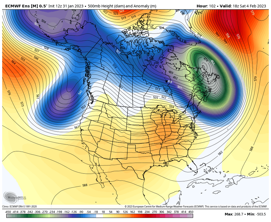

-
Winter 2022/23 Short/Medium Range Discussion
Chicago Storm replied to Chicago Storm's topic in Lakes/Ohio Valley
Final snowfall total of 0.5" at ORD overnight. -
Winter 2022/23 Short/Medium Range Discussion
Chicago Storm replied to Chicago Storm's topic in Lakes/Ohio Valley
Another weak disturbance moving through tonight, producing some fluffy steady snow across the metro area. . -
Tacked on an additional 0.1” from the light precip, for a final snowfall total of 2.3” at ORD. .
-
2.2” of snow at ORD as of midnight. With only light mixed precip remaining, that might be the final total. .
-
Widespread 3-6" reports across NE IA/S WI/N IL thus far. Things are going about as expected at this point.
-
1.7” of snow at ORD through 6PM.
-
It’s rare that the afternoon CLI will have the current snowfall. Yesterday was one of those rare occasions. .
-
Just over a 1/2” off snow here at home so far. Have been riding the edge. .
-
It has been snowing here at home since around 10:45AM. Snow has varied in intensity, with periods of +SN and 1/4SM vis at times.
-
i’m waiting in the shadows. .
-
Winter 2022/23 Short/Medium Range Discussion
Chicago Storm replied to Chicago Storm's topic in Lakes/Ohio Valley
That's a no. -
Winter 2022/23 Short/Medium Range Discussion
Chicago Storm replied to Chicago Storm's topic in Lakes/Ohio Valley
The SPV is taking a beating. That's one of the reasons why the pattern is and has been volatile. -
Winter 2022/23 Short/Medium Range Discussion
Chicago Storm replied to Chicago Storm's topic in Lakes/Ohio Valley
1/8SM vis in the heart of this squall. . -
Winter 2022/23 Short/Medium Range Discussion
Chicago Storm replied to Chicago Storm's topic in Lakes/Ohio Valley
Graupel and +SN in this squall. . -
Winter 2022/23 Short/Medium Range Discussion
Chicago Storm replied to Chicago Storm's topic in Lakes/Ohio Valley
Clipper snow showers are producing… Down to 1/4SM in one of them here at home right now. . -
Midwest/Ohio Valley/Great Lakes Snow January 24-26
Chicago Storm replied to Baum's topic in Lakes/Ohio Valley
Inverted trough/LE combo creating the goods in SW MI… . -
given your recent sequence... primed for by morning, followed by a return to good vibes by later tomorrow.
-
Midwest/Ohio Valley/Great Lakes Snow January 24-26
Chicago Storm replied to Baum's topic in Lakes/Ohio Valley
STL ended up with 2.1", dumbass. -
he's been very wishy washy...very un-alek like.
-
Chicago Weather Records Tracking
Chicago Storm replied to Chicago Storm's topic in Lakes/Ohio Valley
Also, we were within a days of jumping on to about 5-10 other top 10 futility lists. So close, yet so far...