Chicago Storm
-
Posts
19,232 -
Joined
-
Last visited
Content Type
Profiles
Blogs
Forums
American Weather
Media Demo
Store
Gallery
Everything posted by Chicago Storm
-

Midwest/Ohio Valley/Great Lakes Snow January 24-26
Chicago Storm replied to Baum's topic in Lakes/Ohio Valley
Appears to be the case further north, but not further south. . -
Midwest/Ohio Valley/Great Lakes Snow January 24-26
Chicago Storm replied to Baum's topic in Lakes/Ohio Valley
1.7” at ORD as of 6AM. . -
Midwest/Ohio Valley/Great Lakes Snow January 24-26
Chicago Storm replied to Baum's topic in Lakes/Ohio Valley
Snow has begun to spread into the Chicago metro area. 1-3” on the way area wide. -
Midwest/Ohio Valley/Great Lakes Snow January 24-26
Chicago Storm replied to Baum's topic in Lakes/Ohio Valley
Not to be a killjoy for those in the main axis across portions of IL/IN/OH/MI, but I wouldn't put too much stock in this snow maps showing a wide axis of 6-12" amounts. Most foreign guidance is a drier/less snowy than American guidance. We've seen that battle many times in the past, and know how it often plays out. Would lean towards a solid corridor of 2-5" to 4-7" in the main axis, locally higher. -
Midwest/Ohio Valley/Great Lakes Snow January 24-26
Chicago Storm replied to Baum's topic in Lakes/Ohio Valley
Yea, that's a big stretch there. -
ILX has been doing some good things recently, on top of that Twitter thread.
-
Data flow issues.
-
Midwest/Ohio Valley/Great Lakes Snow January 24-26
Chicago Storm replied to Baum's topic in Lakes/Ohio Valley
Definitely not something I would say. -
The next potential of interest. A wave comes into the PAC NW and then quickly moves east across the CONUS, in the vicinity of a tight baroclinic zone. The key will be not having the wave shear out too quickly. .
-
Midwest/Ohio Valley/Great Lakes Snow January 24-26
Chicago Storm replied to Baum's topic in Lakes/Ohio Valley
the NAM is an easy toss for around here. -
Midwest/Ohio Valley/Great Lakes Snow January 24-26
Chicago Storm replied to Baum's topic in Lakes/Ohio Valley
Kuchera will be the way to go over 10:1 in this case. -
The Appetizer: Light Snow general 1-2 " event 1/22-1/23
Chicago Storm replied to Baum's topic in Lakes/Ohio Valley
DAB+ . -
The Appetizer: Light Snow general 1-2 " event 1/22-1/23
Chicago Storm replied to Baum's topic in Lakes/Ohio Valley
Snow has been burst-y much of the night and into this morning/afternoon around here. Looks like around 1.5” here at home. ORD had 0.9” as of 6AM. No word on what final total is there, though. Edit: An additional 0.6” at ORD as of noon, for a likely final total of 1.5” -
Midwest/Ohio Valley/Great Lakes Snow January 24-26
Chicago Storm replied to Baum's topic in Lakes/Ohio Valley
. -
Winter 2022/23 Medium/Long Range Discussion
Chicago Storm replied to Chicago Storm's topic in Lakes/Ohio Valley
Pattern continues to look solid, as we have shifted from long range/ENS range to more short and mid range. Winter lovers can’t ask for more right now. . -
Midwest/Ohio Valley/Great Lakes Snow January 24-26
Chicago Storm replied to Baum's topic in Lakes/Ohio Valley
probably roughly in the 8-12” range, give or take a bit. . -
Midwest/Ohio Valley/Great Lakes Snow January 24-26
Chicago Storm replied to Baum's topic in Lakes/Ohio Valley
just can’t get into this one without at least medium dog potential. . -
Midwest/Ohio Valley/Great Lakes Snow January 24-26
Chicago Storm replied to Baum's topic in Lakes/Ohio Valley
Not only does the main closed wave location factor in, but phasing/shearing with additional waves diving SE in the trough are a significant thing to watch in the coming days as well. . -
-
The Appetizer: Light Snow general 1-2 " event 1/22-1/23
Chicago Storm replied to Baum's topic in Lakes/Ohio Valley
at this point, that doesn't even look to be the case. -
The Appetizer: Light Snow general 1-2 " event 1/22-1/23
Chicago Storm replied to Baum's topic in Lakes/Ohio Valley
indeed. . -
weekend gonna be a dab now, and next week will miss south. .
-
Midwest/Ohio Valley/Great Lakes Snow January 24-26
Chicago Storm replied to Baum's topic in Lakes/Ohio Valley
The guy that always complains that PIA is getting missed forgets a top 5 snowstorm in PIA over the last 10 years. -
Winter 2022/23 Medium/Long Range Discussion
Chicago Storm replied to Chicago Storm's topic in Lakes/Ohio Valley
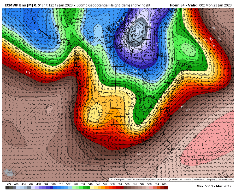
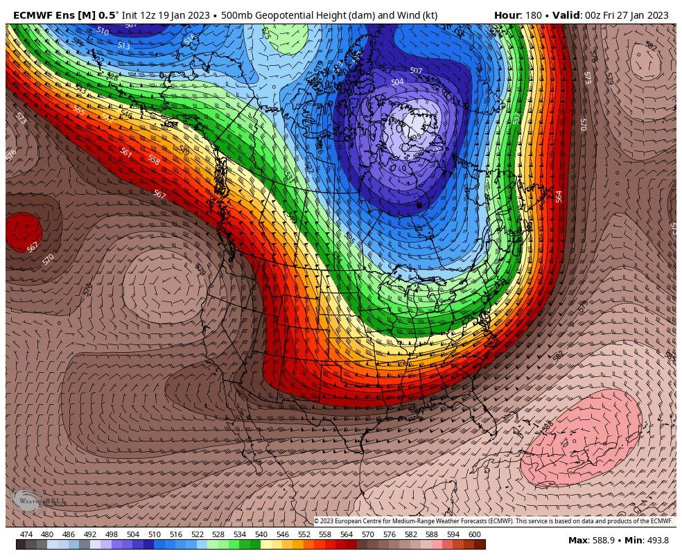
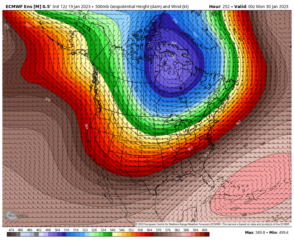
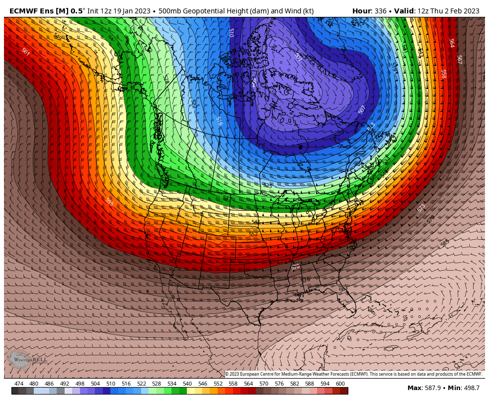
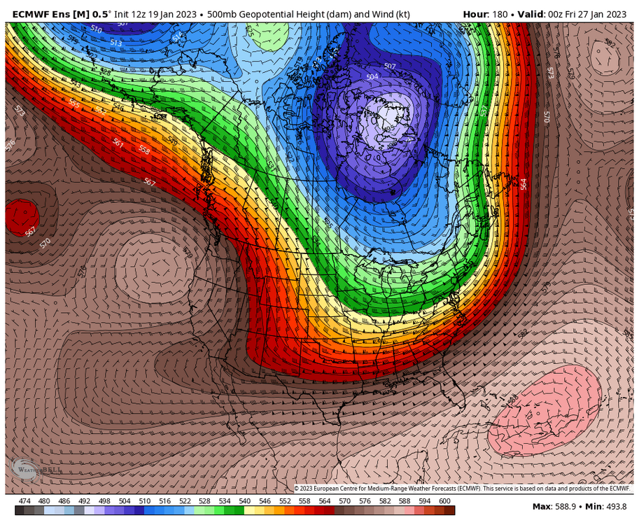
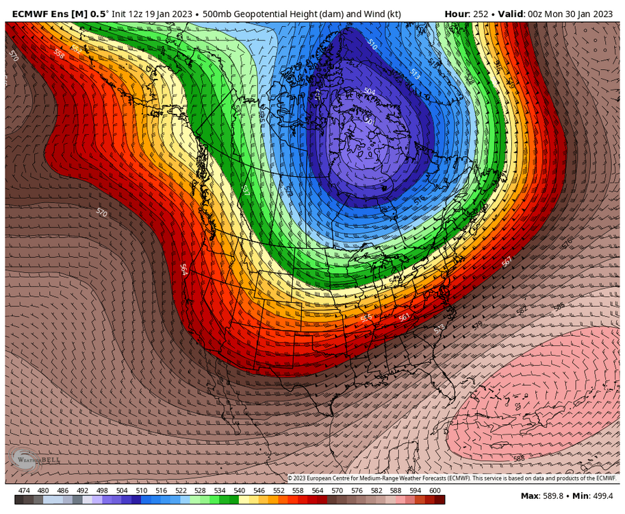
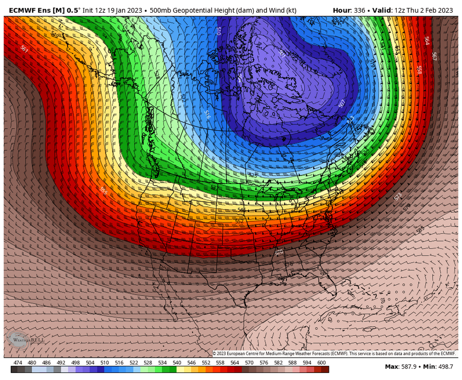
I was going to let OHweather and Ricky handle the final 1/3rd of January into the start of February with their posts from a few days ago, but I changed my mind. Let's toss some more thoughts into the ring. As expected, the long awaited pattern change is underway, essentially being kicked off with the current storm system moving through the region. This pattern really isn't one that will be set in stone or locked in place as a whole, with things likely to be ever changing/evolving as we work through this final 1/3rd of January and through the first 1/3rd of February. Things will start off with what everyone can see being modeled for this weekend and through next week. The lower atmosphere PV axis will be elongated, extending from the Svalbard region to Greenland to the Hudson. There will be a few attempts at a -NAO, but nothing too significant or overpowering as it looks now. Additionally, we will see constant troughing into the Western/Central US, though this trough axis will be displaced east, with a mor eneutral PNA in place. Pac waves will top the -EPO ridge, and then crash into Canada and down into the Western/Central US. It should be noted that this does not look like as signififcant of a -EPO as was seen about a month or so ago. This pattern leads to a continued active time across the CONUS and leads us to the upcoming potential for the weekend and mid next week storm systems, both of which will heavily rely on phasing and wave interaction. Beyond the mid-week storm system there looks to finally be support for a shot at some colder temperatures for a period of time for at least part of the sub-forum, supported by SPV stretching movement and MJO movement. As we move into the period of the final weekend in January, the shared week of the end of January/beginning of February and the first weekend of February, we will see the pattern continue to evolve. The lower atmosphere PV axis will continue to be elongated from the Svalbard region to Greenland to the Hudson. Any attempts at a -NAO may tend to subside a bit with time, and we will steadily see a transition to a more significant -PNA/Western US trough and a relax of the -EPO. This should allow for a continued active pattern across the CONUS. This will be sort of a gamblers pattern....With cold air nearby finally, Western US/North-Central US trough and some from of SE ridge. Who will end up on the right/wrong side of things will is tbd. The early February portion of this period is still 2 weeks + away, so could expect possibly some changes, especially with how volatile things will be for quite a while...But did want to mention where things may head. The changing teleconnections, evolving MJO and assault on the SPV will make for volatile times in general, from late this month on into February, that's for sure.
- 815 replies
-
- 17
-

-

-
Midwest/Ohio Valley/Great Lakes Snow January 24-26
Chicago Storm replied to Baum's topic in Lakes/Ohio Valley
but are you though?