

Chicago Storm
-
Posts
19,232 -
Joined
-
Last visited
Content Type
Profiles
Blogs
Forums
American Weather
Media Demo
Store
Gallery
Everything posted by Chicago Storm
-

Midwest/Ohio Valley/Great Lakes Snow January 24-26
Chicago Storm replied to Baum's topic in Lakes/Ohio Valley
The outcome of this one will be very dependent on phasing and wave interaction. . -
beavis, is that you? .
-
Jan 19-20: Hoosier is not allowed to start this thread
Chicago Storm replied to mimillman's topic in Lakes/Ohio Valley
Continued on to a flip over to full on PL, and then back to RA. That should be the end of the transitioning for tonight. -
Jan 19-20: Hoosier is not allowed to start this thread
Chicago Storm replied to mimillman's topic in Lakes/Ohio Valley
A lot of changing precip types here at ORD this evening... Since precip began, the sequence has been... -RA, -RAPL, -RA, -RASN and then back to -RA. -
Chicago Weather Records Tracking
Chicago Storm replied to Chicago Storm's topic in Lakes/Ohio Valley
I did have the first 1/2 of winter list ready, but someone forgot to post it. -
you’re new here, you have a lot to learn.
-
new guy wants to consolidate the ohio thread with the regular threads.
-
Chicago Weather Records Tracking
Chicago Storm replied to Chicago Storm's topic in Lakes/Ohio Valley
This will be all-encompassing. Like I said, this is a thread I wanted to start many years ago...but it just never happened. -
Chicago Weather Records Tracking
Chicago Storm replied to Chicago Storm's topic in Lakes/Ohio Valley
I have more lined up that are just outside of the top 10. However, for the sake of not jinxing them with some wrap around flakes tomorrow or weekend snow, will hold off on posting those for now. We'll start by easing into it, with the one below that Beavis won't be fond of. Latest 2.0"+ Snow Depth: 1. 2/4/1989 2. 2/3/1983 3. 2/2/2013 4. 1/27/1923 5. 1/21/1937 6. 1/20/2000 7. 1/18/1914 8. 1/17/2023 9. 1/16/2002 9. 1/16/1924 9. 1/16/1907 Days Since Last 2.0"+ Snow Depth: 1. 404 - 12/19/1921-1/26/1923 2. 356 - 4/3/1936-3/24/1937 3. 354 - 2/16/1988-2/3/1989 4. 347 - 1/26/1892-1/6/1893 5. 343 - 2/26/2012-2/2/2013 6. 341 - 3/31/1930-3/6/1931 7. 337 - 1/20-12/21/1968 8. 329 - 2/18/2011-1/12/2012 9. 326 - 2/24/1923-1/15/1924 9. 326 - 2/26/2022-1/17/2023 -
Winter 2022/23 Short/Medium Range Discussion
Chicago Storm replied to Chicago Storm's topic in Lakes/Ohio Valley
The weekend storm system potential is another thread the needle scenario. -
This is a thread I have meaning to start for years now, and what better time than now to finally do it, to start with snowfall futility. Some stats to kick things off coming today… .
-
mine has grown, to say the least. .
-
Jan 19-20: Hoosier is not allowed to start this thread
Chicago Storm replied to mimillman's topic in Lakes/Ohio Valley
Speaking of that… . -
2023 Short/Medium Range Severe Weather Discussion
Chicago Storm replied to Chicago Storm's topic in Lakes/Ohio Valley
Check out the 0-3km CAPE. This was about as thread the needle as you can get severe weather wise.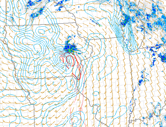
-
how big have your palms gotten? .
-
2023 Short/Medium Range Severe Weather Discussion
Chicago Storm replied to Chicago Storm's topic in Lakes/Ohio Valley
Have been wondering if there was some sort of MVC in E IA, as that whole complex has been spiraling on radar for a while. Upon further review, it looks like that E IA complex is tied to the vort max in the trough moving through. So when combined with the narrow corridor of 50-54 DP's (And the other solid environmental factors), this is probably why we have seen production with there and not much happening anywhere else.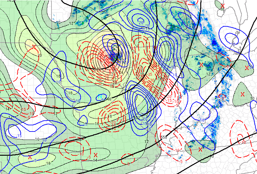
-
2023 Short/Medium Range Severe Weather Discussion
Chicago Storm replied to Chicago Storm's topic in Lakes/Ohio Valley
There's a very narrow axis of 50-54 DP's that have been feeding in, and that was likely just enough to make the magic happen. -
2023 Short/Medium Range Severe Weather Discussion
Chicago Storm replied to Chicago Storm's topic in Lakes/Ohio Valley
famous last words. . -
2023 Short/Medium Range Severe Weather Discussion
Chicago Storm replied to Chicago Storm's topic in Lakes/Ohio Valley
so many poor saps went to iowa for today. kids these days. . -
Jan 19-20: Hoosier is not allowed to start this thread
Chicago Storm replied to mimillman's topic in Lakes/Ohio Valley
and detroit. we need more posters from mn/wi. -
2023 Short/Medium Range Severe Weather Discussion
Chicago Storm replied to Chicago Storm's topic in Lakes/Ohio Valley
There is currently only a handful of DP’s of 50-52 in a very narrow corridor, from SE IA down into E MO. That’s not going to cut it. HRRR definitely taking an L on this one. . -
4.7”* every tenth counts for the winter lovers. .
-
where are the good palms? .
-
2023 Short/Medium Range Severe Weather Discussion
Chicago Storm replied to Chicago Storm's topic in Lakes/Ohio Valley
Shaved a few degrees off the north end. In the end it doesn’t matter much, with the HRRR alone on an island. . -
2023 Short/Medium Range Severe Weather Discussion
Chicago Storm replied to Chicago Storm's topic in Lakes/Ohio Valley
It most definitely took a step back with DP’s. .


