Chicago Storm
-
Posts
19,232 -
Joined
-
Last visited
Content Type
Profiles
Blogs
Forums
American Weather
Media Demo
Store
Gallery
Everything posted by Chicago Storm
-

April 2023 General Discussion
Chicago Storm replied to PositiveEPOEnjoyer's topic in Lakes/Ohio Valley
I posted this in the spring banter thread about two weeks ago, but wanted to update April 2023 data and add two extra data points as well (≤32 low temps and ≤45 high temp counts). As crappy as some think it was, it really was just an average April for Chicago and nearby areas. If you want to argue the cool/mild periods were flip flopped, sure, but otherwise it was a very April-like April. April Averages 60+ Highs: 14.0 70+ Highs: 5.6 80+ Highs: 1.4 ≤45 Highs: 4.1 ≤32 Lows: 6.0 Month Average: 49.8 April 2023 60+ Highs: 17 70+ Highs: 8 80+ Highs: 4 ≤45 Highs: 2 ≤32 Lows: 5 Month Average: +2.0 April 2022 60+ Highs: 9 70+ Highs: 3 80+ Highs: 1 ≤45 Highs: 6 ≤32 Lows: 5 Month Average: -2.7 April 2021 60+ Highs: 15 70+ Highs: 8 80+ Highs: 3 ≤45 Highs: 2 ≤32 Lows: 3 Month Average: +2.2 April 2020 60+ Highs: 14 70+ Highs: 4 80+ Highs: 1 ≤45 Highs: 3 ≤32 Lows: 3 Month Average: -1.3 April 2019 60+ Highs: 14 70+ Highs: 5 80+ Highs: 1 ≤45 Highs: 2 ≤32 Lows: 5 Month Average: 0.0 April 2018 60+ Highs: 8 70+ Highs: 1 80+ Highs: 1 ≤45 Highs: 14 ≤32 Lows: 16 Month Average: -8.5 April 2017 60+ Highs: 19 70+ Highs: 11 80+ Highs: 1 ≤45 Highs: 0 ≤32 Lows: 0 Month Average: +4.0 April 2016 60+ Highs: 12 70+ Highs: 8 80+ Highs: 2 ≤45 Highs: 6 ≤32 Lows: 7 Month Average: -1.9 April 2015 60+ Highs: 16 70+ Highs: 3 80+ Highs: 0 ≤45 Highs: 0 ≤32 Lows: 4 Month Average: -0.3 April 2014 60+ Highs: 14 70+ Highs: 5 80+ Highs: 1 ≤45 Highs: 3 ≤32 Lows: 6 Month Average: -1.1 April 2013 60+ Highs: 11 70+ Highs: 3 80+ Highs: 1 ≤45 Highs: 8 ≤32 Lows: 6 Month Average: -2.8 April 2012 60+ Highs: 16 70+ Highs: 3 80+ Highs: 0 ≤45 Highs: 0 ≤32 Lows: 2 Month Average: +1.0 -
Gonna put in the garden this upcoming weekend.
-
it still does. ens>op guidance.
-
data says, learn your climo. ...April 60+/70+/80+ Days & Monthly Average By Year For Detroit... April Average 60+: 14.3 70+: 5.8 80+: 1.1 Month Average: 48.9 April 2023 (Thru 4/24) 60+: 11 70+: 7 80+: 4 Month Average: +3.4 April 2022 60+: 9 70+: 4 80+: 1 Month Average: -2.1 April 2021 60+: 14 70+: 6 80+: 3 Month Average: +1.7 April 2020 60+: 11 70+: 2 80+: 0 Month Average: -2.8 April 2019 60+: 13 70+: 4 80+: 0 Month Average: +0.1 April 2018 60+: 8 70+: 3 80+: 0 Month Average: -5.9 April 2017 60+: 20 70+: 10 80+: 1 Month Average: +5.4 April 2016 60+: 11 70+: 4 80+: 1 Month Average: -2.6 April 2015 60+: 20 70+: 3 80+: 0 Month Average: +1.1 April 2014 60+: 14 70+: 7 80+: 1 Month Average: 0.0 April 2013 60+: 11 70+: 4 80+: 1 Month Average: -2.5 April 2012 60+: 15 70+: 4 80+: 0 Month Average: +0.5
-
Spring 2023 Medium/Long Range Discussion
Chicago Storm replied to Chicago Storm's topic in Lakes/Ohio Valley
It was hail. -
Spring 2023 Medium/Long Range Discussion
Chicago Storm replied to Chicago Storm's topic in Lakes/Ohio Valley
Correct. For Chicago, the latest trace of snow on record is 5/25/1924 and the latest measurable snow is 5/11/1966. -
April 2023 General Discussion
Chicago Storm replied to PositiveEPOEnjoyer's topic in Lakes/Ohio Valley
I waited for the clouds to clear last night, for a reasonable trip west. Ended up leaving just after midnight, and made it to just northwest of Rochelle by 1AM. Unfortunately, by that time things were quickly fading, so I barely ended up with just a bit of green/purple on the horizon in a few pictures. -
April 2023 General Discussion
Chicago Storm replied to PositiveEPOEnjoyer's topic in Lakes/Ohio Valley
Usually we get several occurrences of graupel each year, during the fall/winter/spring periods. -
April 2023 General Discussion
Chicago Storm replied to PositiveEPOEnjoyer's topic in Lakes/Ohio Valley
long range looks good. . -
April 2023 General Discussion
Chicago Storm replied to PositiveEPOEnjoyer's topic in Lakes/Ohio Valley
A mixed convective rain/snow/graupel shower fest today, and possibly tomorrow as well. . -
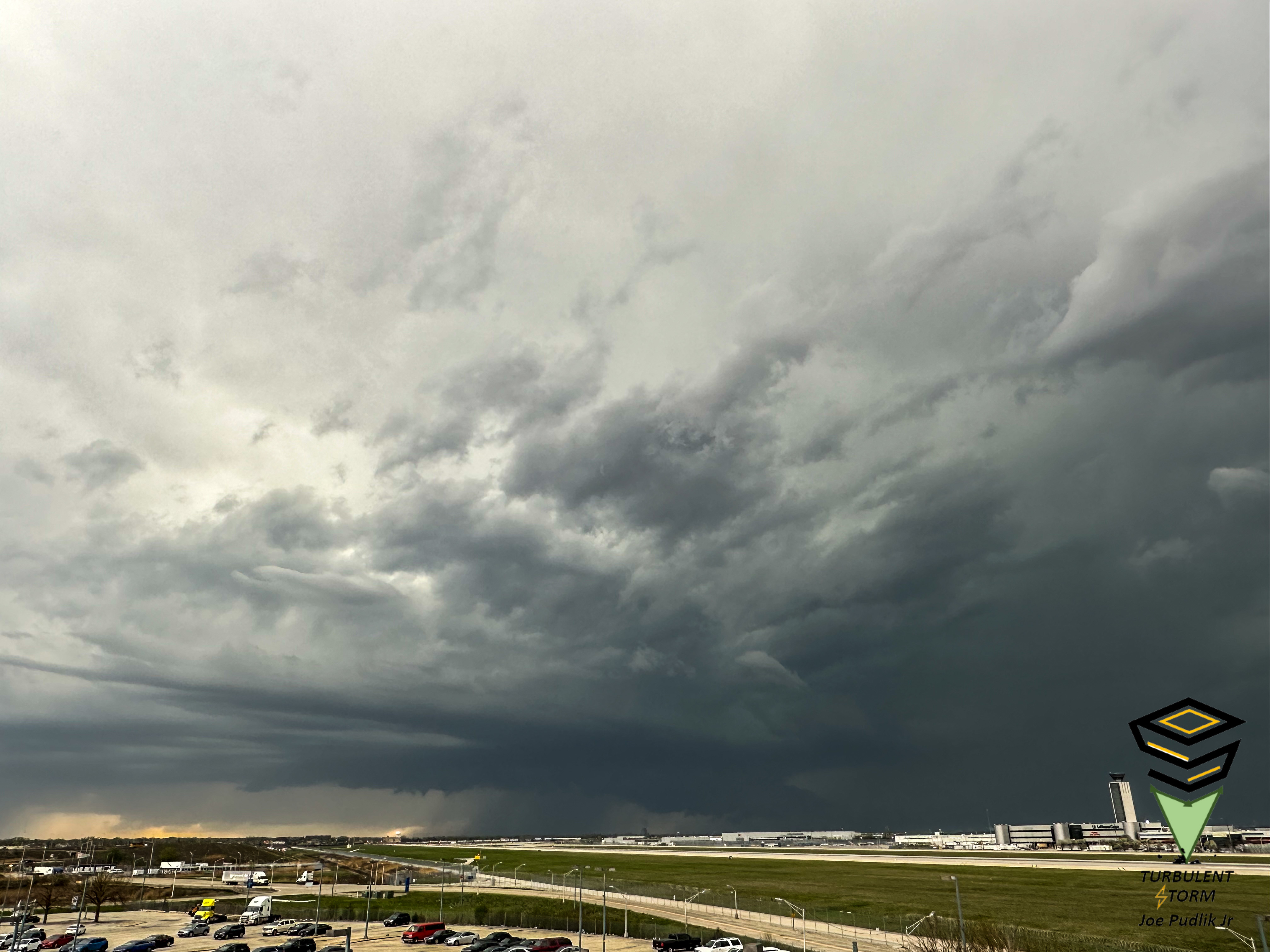
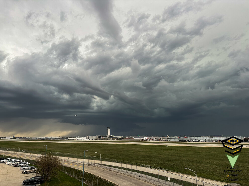
2023 Short/Medium Range Severe Weather Discussion
Chicago Storm replied to Chicago Storm's topic in Lakes/Ohio Valley
Had a view of a wall cloud here at ORD between 5:40-6:10PM, associated with a severe t'storm warned supercell structure that tracked across Kane and Northern Cook Counties.
- 882 replies
-
- 11
-

-
some of ya'll need a touch with reality. outside of 2018, april tends to be what april should be. ...April 60+/70+/80+ Days & Monthly Average By Year For Chicago... April 2023 (Thru 4/19) 60+: 13 70+: 7 80+: 4 Month Average: +6.8 April 2022 60+: 9 70+: 3 80+: 1 Month Average: -2.7 April 2021 60+: 15 70+: 8 80+: 3 Month Average: +2.2 April 2020 60+: 14 70+: 4 80+: 1 Month Average: -1.3 April 2019 60+: 14 70+: 5 80+: 1 Month Average: 0.0 April 2018 60+: 8 70+: 1 80+: 1 Month Average: -8.5 April 2017 60+: 19 70+: 11 80+: 1 Month Average: +4.0 April 2016 60+: 12 70+: 8 80+: 2 Month Average: -1.9 April 2015 60+: 16 70+: 3 80+: 0 Month Average: -0.3 April 2014 60+: 14 70+: 5 80+: 1 Month Average: -1.1 April 2013 60+: 11 70+: 3 80+: 1 Month Average: -2.8 April 2012 60+: 16 70+: 3 80+: 0 Month Average: +1.0
-
April 2023 General Discussion
Chicago Storm replied to PositiveEPOEnjoyer's topic in Lakes/Ohio Valley
The difference actually isn’t the lake in this case, with a 5-10MPH westerly wind at ORD. I’d guess it’s more of a case where IND being on the edge of the metro/rural land, with a W-erly wind/less UHI, is making the difference. . -
Spring 2023 Medium/Long Range Discussion
Chicago Storm replied to Chicago Storm's topic in Lakes/Ohio Valley
We saw a similar period during the 1st half of March. During that period we saw a mix of mild (AA) and cool (BA) temps, with an average to above average active pattern. So all in all, this could be similar, just a solid month+ later in the year. -
Spring 2023 Medium/Long Range Discussion
Chicago Storm replied to Chicago Storm's topic in Lakes/Ohio Valley
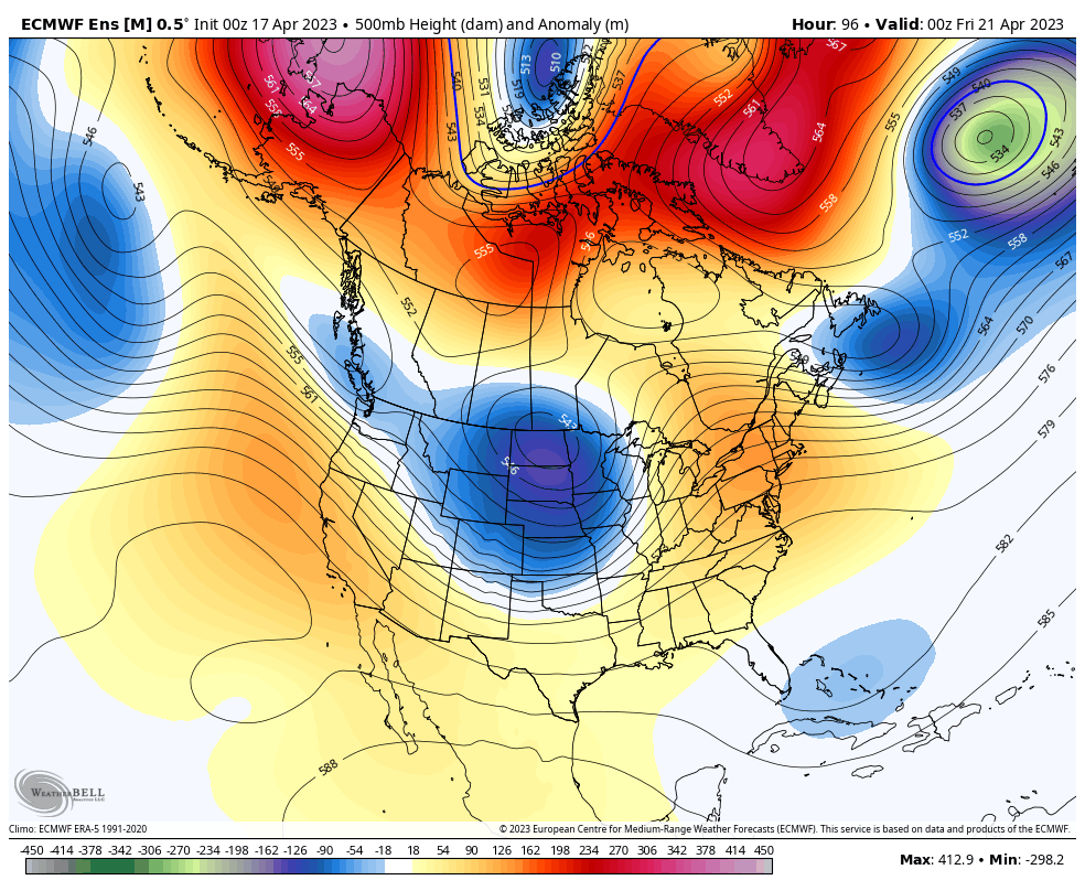
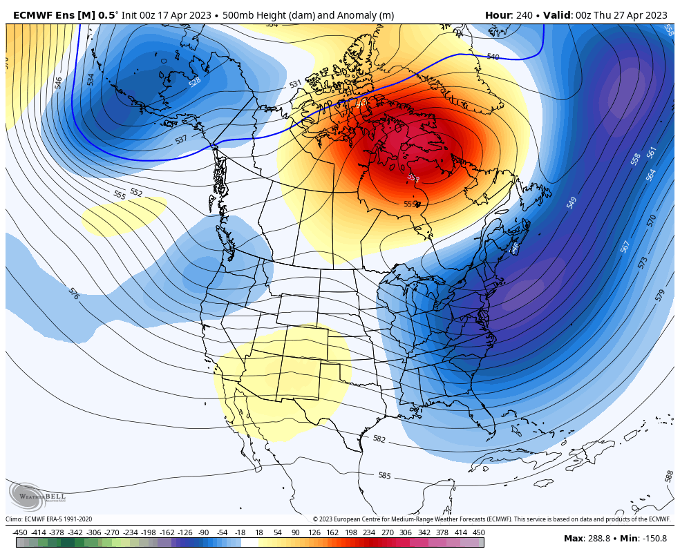
The EPO isn't going negative in any significant or consistent way, and the PNA won't be going positive in any significant or consistent fashion either. As you mentioned though, we will be seeing a -NAO/-AO pattern for this 2nd half of April. Pair that with a EPO/PNA that are going to be in flux throughout, and an MJO steadily sliding through phases 7-8-1-2. This will lead to more a classic spring/April rollercoaster pattern for this 2nd half of April, and into the start of May as well. Bouts of mild and cool temperatures are to be expected, with an average to above average pattern in terms of activity.
-
Spring 2023 Medium/Long Range Discussion
Chicago Storm replied to Chicago Storm's topic in Lakes/Ohio Valley
or not. still will end up with more 70+ days (and 80+ days) than tenths of an inch of total snow, so there's that. -
Chicago Weather Records Tracking
Chicago Storm replied to Chicago Storm's topic in Lakes/Ohio Valley
cancel that. jinxed those. -
The tornado count from the March 31st outbreak in Illinois now stands at 37, making it the 2nd largest tornado outbreak on record for Illinois. DVN is still combing through things, so that number could still change. March 31st, 2023: LOT: 17 DVN: 6 ILX: 12 LSX: 2 EF-U: 4 EF-0: 9 EF-1: 16 EF-2: 7 EF-3: 1 Biggest Illinois Tornado Outbreaks: 1. 39 - 4/19/1996 2. 37 - 3/31/2023 3. 35 - 4/2/2006 4. 29 - 12/1/2018 5. 25 - 11/17/2013
-
April 2023 General Discussion
Chicago Storm replied to PositiveEPOEnjoyer's topic in Lakes/Ohio Valley
The only other two 'triple dip' La Niña occurrences (1974-76 & 1999-2001) were followed by neutral ENSO summer conditions. So this will be new and unknown territory we are entering. -
April 2023 General Discussion
Chicago Storm replied to PositiveEPOEnjoyer's topic in Lakes/Ohio Valley
As posted in the Chicago records thread... ORD had a high temperature of 83° today, which broke the record high temperature for the date of 82°, which was set in 1887 and 1941. -
Chicago Weather Records Tracking
Chicago Storm replied to Chicago Storm's topic in Lakes/Ohio Valley
ORD had a high temperature of 83° today, which broke the record high temperature for the date of 82°, which was set in 1887 and 1941. -
April 2023 General Discussion
Chicago Storm replied to PositiveEPOEnjoyer's topic in Lakes/Ohio Valley
It's not often that you see a full week with temps in the 70's and 80's in mid-April, without any sort of lake breeze...Whether it be in April, May or June. Managed to do it earlier this week with light winds, but good gradient alignment. Now as we have transitioned into mid week, and continuing into late week, stronger winds are preventing development. -
April 2023 General Discussion
Chicago Storm replied to PositiveEPOEnjoyer's topic in Lakes/Ohio Valley
MDW hit 80 for about 2 minutes. -
Final event (April 4th & 5th) tornado count of 9 in IL.
-
It’s currently 93° in Pierre, SD and 50° in Aberdeen, SD…With a difference of 150 miles between both locations. That’s probably one of the sharper non-frontal boundary gradients you’ll ever see. Check out the significant inversion on the HRRR simulated sounding, from along the SD/ND border this afternoon.