LibertyBell
-
Posts
44,789 -
Joined
Content Type
Profiles
Blogs
Forums
American Weather
Media Demo
Store
Gallery
Everything posted by LibertyBell
-
Wow thanks, Don, I wonder had there been weather instrumentation in Central Park it would have recorded a colder temperature than the -15 recorded in February 1934? The only colder temperature I see from New York City is the report of -16 during an extreme arctic outbreak in January 1783 (also after a volcanic eruption-- that was the famous one in Iceland.)
-

Snowfall NYC subforum Jan 6 and OBS if needed
LibertyBell replied to wdrag's topic in New York City Metro
a road trip to Long Beach for this storm, JM? -
If you've been through it before it doesn't mean as much. And it's much easier coping with missing a 6-8 inch snowstorm vs missing a 2 feet snowstorm (like what happened on 2-6-2010).
-
this is what stat geeks say when they don't understand science. we see this all the time in sports, some phantom goddess called *luck* is blamed when there are rational scientific reasons for everything. hint: if it was *luck* it wouldn't keep happening over and over again. Judge's bad performance in the playoffs... *luck*... sure keep telling yourself that (I'm sure he does too lol.)
-
Thanks, Tony, I loved reliving this, especially seeing the yellow radar reflectivity bands just sitting over us for hours! Do you have links like this for the January 2016 HECS too?
-
Is the faster jet stream occurring because the atmosphere is trying to balance out the heat and spread it more equitably?
-
we got a lot more than 9.8 inches here in western Long Island with all day blizzard conditions, more like 15-16 inches! Those were the good old days....
-
is this also the reason for no coastals?
-
2018: NOAA's GOES-East satellite caught a dramatic view of the Bombogenesis 'Bomb Cyclone' moving up the East Coast on the morning of January 4, 2018. The powerful nor'easter is battering coastal areas with heavy snow and strong winds, from Florida to Maine. Notice the long line of clouds stretching over a thousand miles south of the storm. The storm is drawing moisture all the way from deep in the Caribbean. wild, this was the all day blizzard with 6 hours of whiteout conditions!! 16 inches of snow here
-
You'll do better but this area will likely be screwed. This is a thread the needle pattern.
-
It checks with what I read in the Pennsylvania Weather Book, where a number of our coldest and snowiest winters during the 1800s were during the 1830s. A couple of those winters (1832-33 and 1835-36 I think?) reportedly had continuous snow cover in NYC and Philly from Thanksgiving through St Paddy's Day and 100 inches total snowfall in both cities. And this is using the old measuring technique when snowfall was only measured at the end of the event.
-
Maybe they are talking about wind chills, but even so.... the idea that some are thinking of replacing reporting actual temperatures with wind chill *temperatures* is mind boggling.
-
I thought the Daily Planet was from Superman. Something else I have noticed is, aside from low temperatures, they are showing wind chill temperatures only. I have even heard TV weather presenters (are they actually meteorologists?) say that actual temperatures *do not matter* and that the general public should only be told what the wind chill *temperature* is.
-
Question, why doesn't the air ever come in a straight direction instead of taking all these weird squiggly turns and loops? If humans ever become advanced enough to modify the climate on purpose, that's the first thing I would fix.
-
I don't know about cross polar flow, but it sure is cold tonight, this horrible wind is really hitting me in my bones lol. Last week, TWC was saying that this air is coming from Siberia.....
-
The Kuril Islands are at a high latitude, do you think it could influence the climate? I guess so, if a volcano in Iceland can do it too.
-
it really can happen in any kind of ENSO, the blocking is what matters.
-
Snowfall NYC subforum Jan 6 and OBS if needed
LibertyBell replied to wdrag's topic in New York City Metro
2-4 inches sounds interesting south of I-80 although it's also worth noting that the more east you go, the further south the snow shield will be, -
the only other winter that came close was 02-03. And we had it with two completely opposite ENSO, but both had sustained NAO blocking.
-
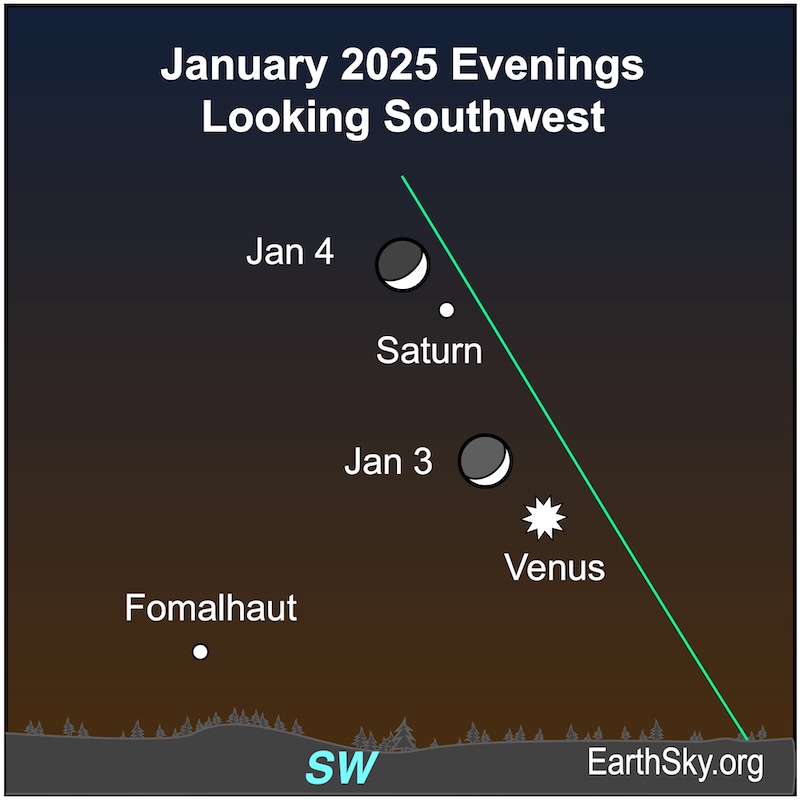
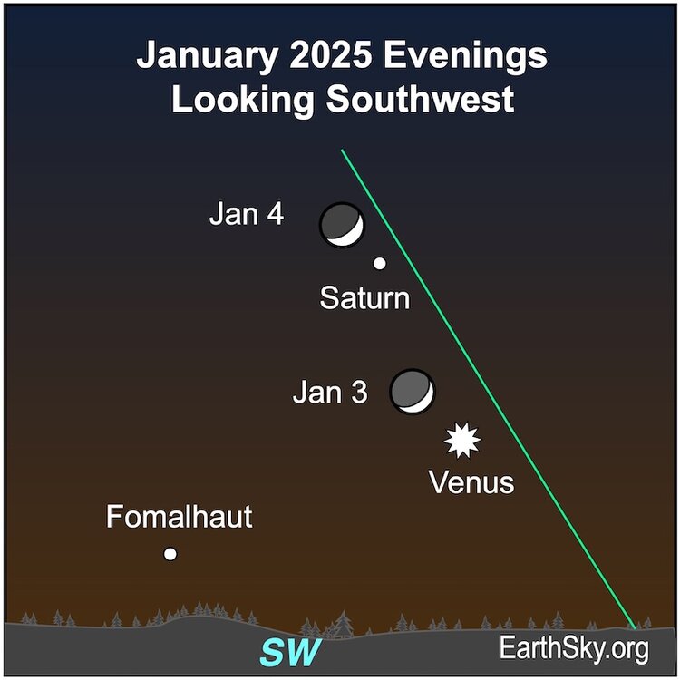
Yup, it's Venus, tomorrow night it will be Saturn. https://earthsky.org/astronomy-essentials/visible-planets-tonight-mars-jupiter-venus-saturn-mercury/ The waxing crescent moon will lie between brilliant Venus and Saturn about 2 hours after sunset on January 3. The moon moves closer to Saturn on January 4. Observers in parts of Africa, Europe and Greenland will see the moon occult – or pass in front of Saturn – at 17 UTC on January 4. The bright – and often called the loneliest star – Fomalhaut is nearby. Look for earthshine – that’s light reflected from Earth – on the unlit portion of the moon. They’ll set mid-to-late evening. Chart via EarthSky.
-
Our TV networks and even TWC certainly love to talk about it. One almost gets the feeling they're jealous because of the attention social media gets.
-
By the way a pretty celestial show in the SW sky right now..... the crescent moon with a very bright planet just to its right.... I think that's Venus?
-
What I found absolutely amazing was that some of that December snow was still around for the January blizzard. We had a white Christmas and white New Years that year, I wonder how often that's happened?
-
Antarctica is a desert. All that snow you see accumulated over thousands of years and never melted (especially near the South Pole.)
-
Didn't we have one around the same time period in 95-96 Chris? I remember an extended cold stretch that began with an MECS in December and ended with an HECS in January. Seems like December-early January cold snaps are fairly common in La Ninas but snowstorms come down to NAO blocking.