-
Posts
42,229 -
Joined
Content Type
Profiles
Blogs
Forums
American Weather
Media Demo
Store
Gallery
Posts posted by LibertyBell
-
-
32 minutes ago, Rjay said:
Too windy for a perfect 10 but it's really nice out.
Tomorrow will be a Perfect 10, just in time for Mother's Day!!
-
 1
1
-
-
37 minutes ago, bluewave said:
There is actually a cool bias at times at Newark since the ASOS is right on the water and gets a sea breeze. You will notice several more inland NJ sites having a similar number or more 90° days than Newark does. This is the total 90° count for the 2020s in NJ so far with the Harrison and Hightstown beating Newark for 90° days.
90 day Data for January 1, 2020 through May 9, 2025
Click column heading to sort ascending, click again to sort descending.HIGHTSTOWN 2 W COOP 204 HARRISON COOP 195 Newark Area ThreadEx 183 NEWARK LIBERTY INTL AP WBAN 183 CANOE BROOK COOP 173 FREEHOLD-MARLBORO COOP 170 ESTELL MANOR COOP 169 SOMERSET AIRPORT WBAN 167 CALDWELL ESSEX COUNTY AP WBAN 162 SOUTH JERSEY REGIONAL AIRPORT WBAN 160 New Brunswick Area ThreadEx 154 NEW BRUNSWICK 3 SE COOP 154
But extreme heat seems to elude Newark, if you go back to 1993, Newark had a 5 day streak of 100+ and 9 total days of 100+ including hitting 105 twice. This is backed up by NYC hitting 100+ three days in a row and JFK hitting 100+ two days in a row. That's what I mean by a really hot summer.
-
4 minutes ago, bluewave said:
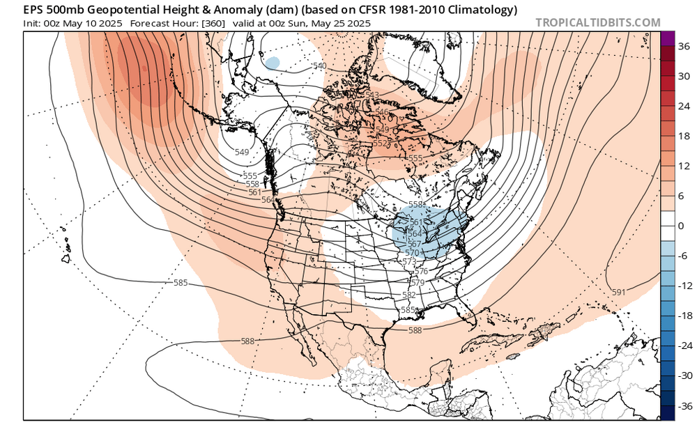
Yeah, we’ll see how it goes. But it does look like 90° potential will probably wait until after the Memorial Day weekend.
While recent years had under 40 days at Newark with the first 90° holding off until after June 1st, the last time the first 90° getting delayed into June reached 40 days was 1983. But that was after a super El Niño winter and not a La Niña like this year.
The real test will probably come during the last week of May which is beyond the 15 day model range. If a 90° day can’t sneak in that week, then the chances for Newark reaching 40 days this year could be diminished based on the past.
All years at Newark with 40 days reaching 90° and the 1st 90° day
2010….54….4-7
2022….49….5-21
1993…..49….5-9
1988….43…..5-31
2021....41……5-19
1991….41……5-12
2016...40…..5-25
1983…40…..6-12
1959….40…..5-12
How many 90 degree days did NYC and JFK have in 2022? That 49 number for Newark seems rather high and doesn't fit the profile of the other summers around it which were hotter.
1983, 1991, 1993, 2010 were all much hotter summers.
-
 1
1
-
-
2 minutes ago, bluewave said:
Yeah, we’ll see how it goes. But it does look like 90° potential will probably wait until after the Memorial Day weekend.
While recent years had under 40 days at Newark with the first 90° holding off until after June 1st, the last time the first 90° getting delayed into June reached 40 days was 1983. But that was after a super El Niño winter and not a La Niña like this year.
The real test will probably come during the last week of May which is beyond the 15 day model range. If a 90° day can’t sneak in that week, then the chances for Newark reaching 40 days this year could be diminished based on the past.
All years at Newark with 40 days reaching 90° and the 1st 90° day
2010….54….4-7
2022….49….5-21
1993…..49….5-9
1988….43…..5-31
2021....41……5-19
1991….41……5-12
2016...40…..5-25
1983…40…..6-12
1959….40…..5-12
1983 was a genuinely hot summer, none of these post 2013 summers have been hot like that.
-
54 minutes ago, bluewave said:
Looks like a delayed first 90° of the season for the warm spots like Newark. Models still have the upper low sitting over the Northeast on Memorial Day weekend. If this forecast does indeed verify, then it could mean that a summer like 2021 and 2022 for over 40 days reaching 90° near Newark may be less likely. This was the case in 2020 with the delayed first 90° into early June signaling fewer 90° days overall. These days Newark needs 40 or more days reaching 90° to be considered to be a high number.
First/Last Summary for NEWARK LIBERTY INTL AP, NJ
Each section contains date and year of occurrence, value on that date.
Click column heading to sort ascending, click again to sort descending.Minimum 04-13 (2023) 08-27 (2020) 81 Mean 05-16 09-11 118 Maximum 06-06 (2020) 10-02 (2019) 147 2024 05-02 (2024) 90 08-28 (2024) 95 117 2023 04-13 (2023) 92 09-08 (2023) 92 147 2022 05-21 (2022) 95 09-04 (2022) 93 105 2021 05-19 (2021) 91 09-15 (2021) 91 118 2020 06-06 (2020) 91 08-27 (2020) 93 81 2019 05-26 (2019) 90 10-02 (2019) 96 128 2018 05-02 (2018) 90 09-06 (2018) 98 126 2017 05-17 (2017) 92 09-25 (2017) 90 130 2016 05-25 (2016) 91 09-23 (2016) 90 120 2015 05-25 (2015) 90 09-09 (2015) 91 106
Time Series Summary for NEWARK LIBERTY INTL AP, NJ - Jan through Dec
Click column heading to sort ascending, click again to sort descending.2024 33 0 2023 29 0 2022 49 0 2021 41 0 2020 31 0 2019 27 0 2018 36 0 2017 22 0 2016 40 0 2015 35 0 to be fair our last really hot summer was 2013, Newark is notorious for having a hot bias.
Is this the same low coming back again and again? How long does it take for this thing to dissipate?
-
 1
1
-
-
14 minutes ago, cleetussnow said:
Started. The wind farm out in LI was contracted to charge 300% over spot energy rates…which are terrible to begin with. Who's getting that money? A foreign company thats who. Who’s paying it for it? Subsidized by NY and federal tax payers who don’t even use that power. Its a disgusting deal. The other power source is in another country - Canada - who hate us - dumb dumb dumb. So we have the second highest electricity rates in the US and there is no hope of that changing that unless we can fleece federal taxpayers into subsidies. NO WAY will NY ever build more power plants. Impossible. Except subsidized wind farms.
NY is big on hydroelectric power, that's my favorite energy source (I also love solar, you can make money off a solar farm.)
-
10 minutes ago, IrishRob17 said:
Until your allergies kick in again…
No, my allergies stopped as soon as the rain stopped last night, it was pretty amazing, my allergies are better than radar at detecting rain.
It never happens when it snows though.
-
6 minutes ago, Stormlover74 said:
The wind is back
It got rid of the clouds and rain so it's fine.
-
1 hour ago, bluewave said:
The NAO and AO have become really volatile over the years. With big swings from positive to negative over very short periods. So trying to do a detailed long range AO and and NAO forecast for next winter would probably be low skill at this point.
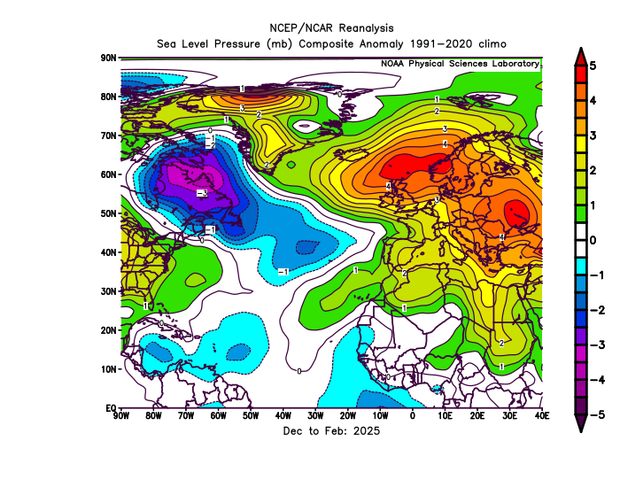
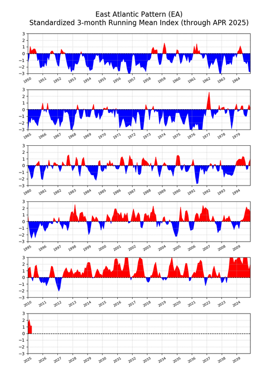
This past winter the AO was negative and the NAO positive. This decoupling between the 2 indices has become more common during the 2020s. Plus on the days with .25 and more of precipitation around NYC this last winter the -AO and -NAO linked up with the Southeast Ridge.My guess is that this is related to surface pressures rising near the Azores during the winter. When the -AO links up with the Southeast Ridge the AO still registers as negative. But when the blocking near Iceland and Greenland links up with the East Atlantic or European Subtropical Ridge, the NAO registers as positive. So the rising pressures to the south near Europe have been preventing more -NAO winters in recent years.
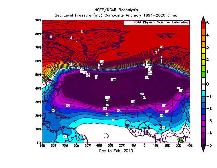
If we had lower pressures near the Azores this past winter, then it would have been a -NAO winter since pressures were above average near Iceland. Notice how much different it was from the pattern in 2010 with the record -NAO.
The shift to a much more positive EA over time seems to have been also influencing the NAO.
Some good reasoning right here, Chris.... what are your thoughts on the increased NAO blocking in springtime, even late springtime (May).... is this a seesaw effect to balance out what we're seeing in the winter?
-
1 hour ago, steve392 said:
A chilly 48 degree's at work this morning with a drizzle to welcome you into work.
well it's been completely sunny here since sunrise.
-
13 hours ago, Sundog said:
Who cares about wind.
NYC was getting 20% of its power from a clean source immune to global price shocks that provided baseload power 24/7.
But no! We had to shut that down!
My bills are pushing DOUBLE what I paid 5 years ago. And I got much more efficient heat pumps installed mind you!
Don't get me started.
If you're a customer of CON Edison, then you should know that they are predatory and have been prosecuted for spiking their prices.
I'm a big believer in publicly controlled utility companies and price controls being in effect.
-
Looks like that last batch of rain is finally coming through.
-
It's raining again, maybe this is that last batch people were talking about coming through?
-
18 minutes ago, SACRUS said:
More strong winds tomorrow morning - afternoon.
This is a boon for the wind turbine industry.
-
5 minutes ago, michsnowfreak said:
Mine would be July 2012. Just gross.
That entire 2010-2013 may not be repeated again for a long time.
What I really liked about it was it was hot and dry.
-
Just now, TheClimateChanger said:
Here is LaGuardia. Regression shows an increase from 10 days of 90+ to 25 days of 90+ since 1960. The peak 5 year moving average was 31 in 2022 - just two summers ago. It's fallen back a small bit over the last 2 summers, but a particularly hot summer this year will likely send it back to a new record 5 yma.
LGA has more of an inland influence so they are lucky enough to avoid the onshore flow we're getting here on the south shore. But as you said, it's much better at EWR, where there a southerly/southwesterly flow doesn't allow the ocean to moderate the air.
The changing position of the Bermuda High is responsible. When we had more 90 degree days here during the 90s, it was south of us, giving us a downsloping westerly flow. Now the Bermuda High and heat has moved north of us giving us more of a southerly flow, which is more humid but caps our heat in the upper 80s.
-
3 minutes ago, TheClimateChanger said:
I'm not sure I buy that. The 5-year moving average for Newark is up to 37 days of 90+ which is the most on record, matching the 5 yma from 1995 [which I have previously explained why the numbers from that era were inflated at first order sites, but everyone here just ignores that fact?]. A regression since 1960 suggests an increase in 90+ days of nearly two weeks over that time period - from 20 to 33 days.
Central Park is the only site that seems to be bucking that trend, but I think @bluewavehas extensively documented the impact of overgrown vegetation surrounding the ASOS site and significant shading of the ASOS.
JFK too, the heat is moving inland, Chris said it's because the Bermuda High is moving north, which is why the heat is focused more inland and we're just getting the humidity (yuck).
Our 90 degree days have not seen an increase in a few decades.
Trust me I wish we were getting hotter drier summers but here on Long Island, they are much wetter and very humid but not as hot. More like Florida's east coast.
-
1 minute ago, LibertyBell said:
I researched that 10 day heatwave in August 1896 that may have had more impact on NYC than any other weather event in history, even more than the March 1888 blizzard.
https://en.wikipedia.org/wiki/1896_Eastern_North_America_heat_wave
Holy f*ck
excuse my language please
The 1896 eastern North America heat wave was a 10-day heat wave in New York City, Boston, Newark and Chicago that killed about 1,500 people in August 1896.[1][2][3]
History
[edit]There were ten days of temperatures at least 90 °F (32 °C) with high humidity and little breeze.[4] The temperatures in New York did not drop below 72 °F (22 °C) at night, with three consecutive nights at 80 °F (27 °C) or above. It killed more than the New York City draft riots and the Great Chicago Fire combined.[2] A majority of the deaths were of working-class men in their twenties who performed manual labor.
The New York City Public Works Commissioner ordered that his workers' shifts be modified so they would not be working during midday, and he had fire hydrants opened to cool people on the street. Theodore Roosevelt, then New York City Police Commissioner, distributed free ice from local police stations. After accidental deaths from people falling off the roofs they were sleeping on, the New York City Parks Department allowed people to sleep in parks overnight.[1][2]
The only good thing about this super heat wave was it was the main reason Teddy Roosevelt became president, he was one of our very best.
-
I researched that 10 day heatwave in August 1896 that may have had more impact on NYC than any other weather event in history, even more than the March 1888 blizzard.
https://en.wikipedia.org/wiki/1896_Eastern_North_America_heat_wave
Holy f*ck
excuse my language please
The 1896 eastern North America heat wave was a 10-day heat wave in New York City, Boston, Newark and Chicago that killed about 1,500 people in August 1896.[1][2][3]
History
[edit]There were ten days of temperatures at least 90 °F (32 °C) with high humidity and little breeze.[4] The temperatures in New York did not drop below 72 °F (22 °C) at night, with three consecutive nights at 80 °F (27 °C) or above. It killed more than the New York City draft riots and the Great Chicago Fire combined.[2] A majority of the deaths were of working-class men in their twenties who performed manual labor.
The New York City Public Works Commissioner ordered that his workers' shifts be modified so they would not be working during midday, and he had fire hydrants opened to cool people on the street. Theodore Roosevelt, then New York City Police Commissioner, distributed free ice from local police stations. After accidental deaths from people falling off the roofs they were sleeping on, the New York City Parks Department allowed people to sleep in parks overnight.[1][2]
-
https://www.weather.gov/okx/heatwaves
Just like I said we used to have some epic heatwaves back in the day, although 2010 had our most 90 degree days here at JFK, our last really long heatwave was in 2002.
Longest Heat Waves - 90 degrees + in a row(through March 10)DaysDatesTemperatures12
August 24 - Sept 4, 1953
91,91,91,94,98,99,98,100,97,102,94,90 11
July 23 - August 2, 1999
92,97,97,93,96,97,93,92,90,98,90 10
July 7 - 16, 1993
August 4 - 13, 189698,100,101,102,97,94,94,91,90,90
90,94,92,97,95,98,94,96,93,909
August 11 - 19, 2002
July 13 - 21, 1977
July 6 - 14, 1966
July 5 - 13, 194492,96,98,95,92,93,94,94,94
93,92,96,98,97,100, 102,92,104
91,93,91,91,91,94,99,101,95
93,94,91,94,92,91,93,93,918
July 29 - August 5, 2002
August 2 - 9, 1980
August 28 - Sept 4, 1973
August 10 - 17, 1944
June 26 - July 3, 190196, 95, 95, 96, 97, 90, 92, 91
91, 92, 91, 94, 93, 94, 96, 95
98, 95, 98, 94, 95, 94, 96, 93
97, 102, 97, 96, 95, 95, 96, 95
91,91,93,95,95,100,100,947
July 29 - August 4, 1995
August 9 - 15, 1998
July 15 - 21, 1991
July 12 - 18, 1983
July 7 - 13, 1981
August 1 - 7, 1955
July 15 - 21, 195393, 93, 91, 94, 96, 90,96
93, 93, 95, 94, 96, 99, 97
90, 93, 96, 99, 96, 100, 102
94, 93, 94, 98, 96, 93, 97
94, 95, 96, 93, 94, 94, 93
98, 100, 90, 95, 100, 97, 93
92, 97, 100, 101, 91, 90, 90 -
Just now, TheClimateChanger said:
I don't think so. Just last summer was the most 90+ days since 1995 at Pittsburgh (24). Humidity is WAY up and average July lows have climbed up about 3-5F just in the past 3 to 4 decades.
For Pittsburgh maybe, but in NYC our very hot summers ended after 2013 with more rain than heat in summer now.
-
2 minutes ago, TheClimateChanger said:
I tend to think July 2020 was the worst of my lifetime. The mean high temperatures were comparable to 1988, but lows were in the mid 60s at most sites. Just lacked the few days in the upper 90s/low 100s, instead topping off mostly in the mid 90s. Most places did not even have a single night below 55, several did not drop below 60 the entire month. Contrast that to 1988, and most rural/suburban sites had average monthly lows in the 50s.
Ours was July 2010, I loved that month !!
-
On 5/8/2025 at 10:14 AM, michsnowfreak said:
To this day, summer 1988 holds the record for the most 90F+ days on record at Detroit (39). With a widespread drought going on, I assume the humidity was unusually low. I was only 5 but Ill never forget seeing a grass fire ignite before my eyes. There was indeed a brief but potent (for the season) cold snap to start July. In fact, DTW had a record low of 48F on July 1st, sandwiched between a sea of record highs in June & July. That summer saw 5 days of 100F+, which is 2nd only to 1936 with 8.
Nevertheless, its an absolute joke to take an alleged 32F reading at a random coop station with a very possibly faulty thermometer in an extremely rural area, in one of the last months that station kept records....and just say "hey it was 32 this day, youd never see that today". BTW the official low at Pittsburgh that day was 49F. Lmao do you know some of the insane readings that come from some of the cold spots in rural Michigan during the summer?
I wonder if these 11 year hot summers are connected to the solar cycle.
Look up these summers, all of them were very hot here:
1933, 1944*, 1955*, 1966*, 1977, 1988, 1999*, 2010*.
A CONUS map of these summers is quite revealing.
* denotes the hottest summer or hottest summer month to that point in the climate history.
-
On 5/6/2025 at 11:31 PM, TheClimateChanger said:
The average July low is up like 3-5F at all of the airports nearest me since 1990. Like here's a more distant suburb of Pittsburgh in 1988. The low was 35, 32 & 36 on July 1-3, 1988. Does anyone think such temperatures are possible today? The only place where such lows can occur today are places like Canaan Valley, West Virginia, which is an elevated (3-4k) frost bowl. Like this is supposed to be the Hottest Summer Ever (TM) and the average low at this location was a cool 55.7F. That's open window weather. Even on the days of 100F, it cooled down into the 50s and low 60s, enabling efficient cooling by a window fan at night.
I fully subscribe to climate change, but you must admit it affects winters much more than it does summers. Summers are judged by high temps anyway, like number of 90 and 100 degree days. The wetter springs and wetter summers are flatlining the number of hot days we have and shortening our heatwaves to 3-5 days or less, when we once used to have much longer heatwaves of 7-10 days or even more multiple times a summer (1999, 2002).
I would dearly like to remove water vapor from the atmosphere and convert it to drinking water, which would ameliorate this issue somewhat.




May 2025
in New York City Metro
Posted
Look at this, I'm privileged enough to remember these summers. 1993 had the hottest period of my life time. It was the first summer I started using air conditioning here. Look at this absolutely amazing streak of 10 days of 90+ and 3 days of 100+ something I am reasonably confident we'll never see again in our lifetime. The amazing thing about the last two days of the 1993 streak is they happened AFTER a cold front had passed through. 90 and dry actually felt COLD
https://www.weather.gov/okx/heatwaves
90,94,92,97,95,98,94,96,93,90
93,92,96,98,97,100, 102,92,104
91,93,91,91,91,94,99,101,95
93,94,91,94,92,91,93,93,91
91, 92, 91, 94, 93, 94, 96, 95
98, 95, 98, 94, 95, 94, 96, 93
97, 102, 97, 96, 95, 95, 96, 95
91,91,93,95,95,100,100,94
93, 93, 95, 94, 96, 99, 97
90, 93, 96, 99, 96, 100, 102
94, 93, 94, 98, 96, 93, 97
94, 95, 96, 93, 94, 94, 93
98, 100, 90, 95, 100, 97, 93
92, 97, 100, 101, 91, 90, 90