-
Posts
42,229 -
Joined
Content Type
Profiles
Blogs
Forums
American Weather
Media Demo
Store
Gallery
Posts posted by LibertyBell
-
-
8 minutes ago, TheClimateChanger said:
I was living in the 90s, and I don't recall it as "much hotter." We didn't even have air conditioning in my bedroom. I don't think you could do that today. It doesn't cool down enough at night to open a window.
it must be a regional thing, 1980, 1983, 1988, 1991, 1993, 1995, 1999 and 2002 were our hottest summers in terms of 90 degree temps. 2010 has been our hottest summer since then.
-
Just now, 40/70 Benchmark said:
...which is ironic....
I think there might be a logical explanation (from the placement of NAO phase summer vs winter to the fact that warmer SST because of a hot summer add extra juice to developing noreasters and also that warmer SST attract colder airmasses during the winter.)
It sure is ironic lol.
-
42 minutes ago, PhiEaglesfan712 said:
The one for PHL is much harder to break. If I remember correctly, the record HI was set three days after my 7th birthday, on 7/15/1995. The high that day was 103, and I believe the HI was 129 and the dewpoint was 82 (which was even higher than the low of 81 that day).
That day was just the perfect storm of the heat and humidity coming together. I can't see it ever being broken. We'll either need a very humid 101/102 degree day or a day when the thermometer reaches 108, which is 2 higher than the all-time PHL record (like it did in Newark in 2011).
Ironically we did not hit 100 here near JFK, that record from 2011 was higher here at the coast (I don't remember what the heat index was at Newark), but I know that NYC hit 104 and JFK hit 103. My personal weather station on the south shore of Long Island hit 105.6 We had a stretch of 4 summers 2010-13 that we hit 100+ every year and the summer before set our records for most 90, 95 and 100 degree days!! In July 2010 we hit 100+ three out of 4 days and 2 more times in July 2011. There was a weather conference in Baltimore around the time of peak heat in July 2011, everyone must have been like roasted lobster down there lol.
-
2 hours ago, 40/70 Benchmark said:
This is why winter is warming faster than summer and nights are warming faster than days. The fastest rate of GW is occuring in instances of radiational cooling during the winter.
this is a form of self regulation by the planet.
-
22 minutes ago, TheClimateChanger said:
Going to tough to break those inflated numbers from the HO-83 era. Big warm bias at the first order sites.
most of us lived through that lol, we remember as the 90s as being much hotter (temperature wise anyway)
-
22 minutes ago, 40/70 Benchmark said:
I remeber that heatwave vividly...I was 14. The irony that it preceded the most severe east coast winter on record...
it's not ironic though many of our best winters are preceded by extreme heat. Examples
1955, 1966, 1977, 1993, 1995, 2002, 2010.
-
 1
1
-
-
19 minutes ago, TheClimateChanger said:
Going to tough to break those inflated numbers from the HO-83 era. Big warm bias at the first order sites.
I think it might be tough to break them because it rains much more now.
Have to remove all that water vapor (another potent greenhouse gas) and convert it to drinking water.
-
 1
1
-
-
5 minutes ago, TheClimateChanger said:
But still had our longest two week of heat ever and even hit 104 degrees in NYC and 100+ a few more times.
Our climate has become a joke now, too much rain and cutoff lows which we never used to see in May before.
With climate modification the first thing I would do is destroy upper level lows.
-
10 hours ago, LongBeachSurfFreak said:
Steady moderate rain again in SW Nassua, rare for this to be the jackpot area. But it seems to just want to train here today. I’ll take it, my veggies are pretty stoked.
I let the pros grow veggies (read I buy them from organic grocery stores), but I do grow flowers and mine look like pancakes from this excessive rainfall.
The first thing I would do with weather modification is put an end to cutoff lows. Showers and Tstorms that come at night after a sunny hot day are fine, not days and days of this Ireland weather crap.
I'd like to know why cutoff lows are on the increase and especially in May, when they never used to happen this late in the season back in the 80s and 90s.
-
31 minutes ago, Brian5671 said:
Waterlogged here after all night showers/downpours with more incoming-going to be one wet week if the Friday event verifies
we're going to have so much mold and fungus from this
-
1 hour ago, bluewave said:
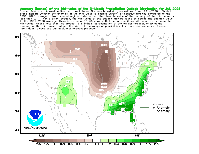
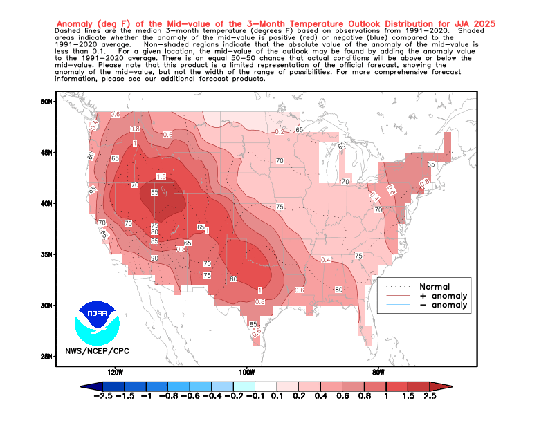
Not sure. But the Euro is usually more accurate with the summer than the winter forecast for us. Probably due to less moving parts in the summer so to speak. The reason it may be wet for us is that there are two ridge centers showing up for the summer forecast. One east of New England and another out West. So perhaps the model is trying to show a weakness in the ridge where there could be some moisture pooling. We’ll see if it has a clue. It’s the same idea as the CPC summer forecast. So probably more high dewpoints and onshore flow like we have been seeing in recent years if correct.
What do you think of the possibilities of the two ridges connecting with each other (creating a ridge bridge as it were lol.)
-
3 minutes ago, 40/70 Benchmark said:
Makes sense given CC leads to increased mositure, this elevating humidity capping heat....its the HI that will be morbid.
Yes that HI will be miserable for us.
It was a few years ago that JFK set their HI record (on back to back days!), both days had a high of 99 and a HI of 117, a true weekend from Hell (complete with power outages!)
-
 1
1
-
-
9 hours ago, donsutherland1 said:
Yes. Almost coast-to-coast warmth.
1980 summer here we come :-)
-
20 minutes ago, bluewave said:
The Euro has two more rainy cutoffs after this one the next few weeks. The next once comes through later in the week. Then another one before the 15th. It will be interesting to see if the Euro is correct about a wet summer for us. As it would keep the strongest heat out West where the drought feedback really kicks in.
The Euro might be wrong about that third one, the NWS has us going into a drier and warmer pattern starting on May 11th (Mothers Day) for an extended period.
-
18 minutes ago, bluewave said:
The Euro has two more rainy cutoffs after this one the next few weeks. The next once comes through later in the week. Then another one before the 15th. It will be interesting to see if the Euro is correct about a wet summer for us. As it would keep the strongest heat out West where the drought feedback really kicks in.
But the X link Tony posted indicated a dry summer for us?
Why are these cutoffs becoming much more common, is it because of climate change too? Back in the 80s and 90s our Mays were much warmer and drier and we didn't see cutoffs after April.
-
10 hours ago, donsutherland1 said:
Additional rain is likely tomorrow and Wednesday. It now appears that the dry respite will be brief. Another storm could affect the region Friday into Saturday before a cooler drier air mass arrives.
The ENSO Region 1+2 anomaly was +0.1°C and the Region 3.4 anomaly was -0.1°C for the week centered around April 30. For the past six weeks, the ENSO Region 1+2 anomaly has averaged +0.68°C and the ENSO Region 3.4 anomaly has averaged -0.05°C. Neutral ENSO conditions will likely continue through at least early summer.
Early indications are that summer 2025 will be warmer than normal in the New York City and Philadelphia areas. The potential exists for a much warmer than normal summer (more than 1° above normal).
The SOI was +1.47 today.
The preliminary Arctic Oscillation (AO) was +0.778 today.
Drier and Warmer weather for an extended period likely to arrive just in time for Mother's Day (May 11th).
-
 1
1
-
-
9 hours ago, Stormchaserchuck1 said:
The only two summers in the 1970s that jump out at me for heat were 1973 and 1977. Before then, our historically hot summers occurred in an 11 year cycle (1944, 1955, 1966.) 1977 still has our hottest two week stretch on record.
Of course the 1980s and 1990s were much hotter, 1980 got things started with a historic CONUS heatwave. If I remember correctly the following summers were very hot: 1980, 1983, 1988, 1991, 1993, 1995, 1999, 2002, 2010-2013
Actually that 11 year solar cycle has still prevailed for summer heat, with a few other years thrown in. Map these years for summer heat: 1933, 1944, 1955, 1966, 1977, 1988, 1999, 2010.
I think that pattern was broken in 2021 when we didn't have that kind of heat.
-
9 hours ago, michsnowfreak said:
Extreme heat is definitely nothing here like it used to be. More days in the 80s and warmer summer nights increase summer mean temps. So I have a hard time seeing any wild uptick In 90s here either.
The climate models were wrong, they actually predicted an average of 3 100 degrees annually for NYC by 2045 and I just don't see that happening.
-
9 hours ago, csnavywx said:
Dangerous risk of termination shock and unexpected circulation changes. But I do think it will be done anyways.
it's going to change the Monsoon season in Asia that's for sure, computer simulations show it moving south with SO2 being added to the atmosphere.
-
8 hours ago, LongBeachSurfFreak said:
This is a stretch for this particular topic but this is the climate change thread.
Personally I’m now hopeful fusion will solve the CO2 crisis. The only thing stopping us from removing CO2 back down to pre industrial levels is a lack of energy. CO2 removal (pumping into the ground being the most effective method) requires a ridiculous amount of energy. With fusion tech and the resulting near limitless energy it’s entirely feasible. AI will likely fast track fusion viability. So a glimmer of light at the end of the tunnel.That would be an interesting twist, use fusion to both replace fossil fuels and remove carbon from the air (and also from the water, I see that is already underway-- carbon in the water leads to coral acidification so it's important to remove.)
We'll also be removing some water vapor from the atmosphere (another greenhouse gas) and use that water vapor to make drinking water for developing nations. This is also important, as water vapor is as much of a villain as carbon dioxide is.
-
2 hours ago, Brian5671 said:
off and on tropical downpours here all afternoon
The Yankees are playing in this weather lol.
-
3 hours ago, LongBeachSurfFreak said:
Actually it would cause an enormous increase in global temperatures from the heat of the fusion reactions. Followed by a global firestorm similar to that after Chicxulub. Many months later when the fires smolder out and dust blocks the sun, then the nuclear winter begins.
The comparison to the great K-T event is what would finally fix our climate change and human overpopulation problem, both in one shot.
-
-
34 minutes ago, csnavywx said:
Planck feedback/response stops any sort of Venusian runaway on this planet. Would take much higher insolation to get us there.
Much more worried about plant and/or soil carbon stock turning unstable at current temperatures. It's been showing signs the last few years, esp with large emissions from respiration. South America and southern Africa in particular do not seem to be taking it well. Some of this is probably due to monsoon trough migration via differential hemispheric heating and boosted non-CO2 warming recently from aerosols and higher-than-trend CH4, causing a lopsided NH response. But if the Amazon and southern African tropical sinks can no longer provide a brake, then that will cause an immediate and relatively strong increase in the airborne fraction.
how do you feel about these ideas to drop insolation 1-2 percent by introducing SO2 particles into the upper atmosphere?
it would have to be done on a yearly basis, beginning around 2030


2024-2025 La Nina
in Weather Forecasting and Discussion
Posted
I really don't concern myself with low temps-- I use 90 degree temps to define heat (it's also the official NWS definition to rank summers by number of 90 degree days.)
Higher overnight lows are the result of more water vapor.