-
Posts
42,229 -
Joined
Content Type
Profiles
Blogs
Forums
American Weather
Media Demo
Store
Gallery
Posts posted by LibertyBell
-
-
7 minutes ago, LongBeachSurfFreak said:
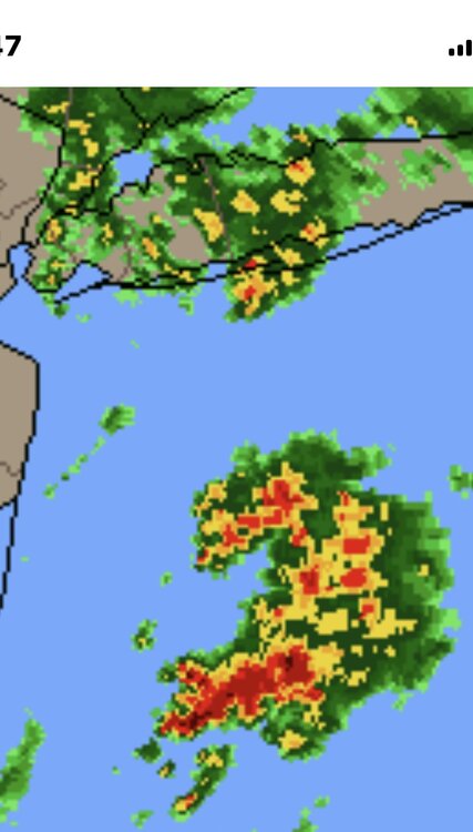
Check out Rhode Island right now. That’s a serious slug of moisture.
Hard to believe our rainfall totals are under one inch. But it looks like we'll end up in the .50-1.00 category, with the 1+ inches in eastern LI and NW areas.
It's plenty of rain, looks like it's 90% done. Might get another tenth out of this that's about it.
-
13 minutes ago, michsnowfreak said:
Thank you

Yes Happy Get Your Freak On Day-- I hope you have a full weekend of celebrating!!
-
 1
1
-
 1
1
-
-
1 hour ago, michsnowfreak said:
My birthday is May 8th so the weather can be very variable this time of year, but by a mile 2020 was my coldest birthday. I wore a turtleneck sweater that day. It flurried all day in a brisk breeze then we got to a record low of 27F the next morning, one of the coldest May temps on record.
That was Saturday May 10th in the Poconos, snow squalls periodically throughout the day, including some heavier bursts of snow that lay down dustings and coatings. The morning low was in the upper teens with wind chills around 0.
-
 2
2
-
-
1 hour ago, MANDA said:
Received .40" snowfall with a morning low temperature of 26 degrees.
I was at a funeral down in Trenton in 1977. I was a young teenager and I remember standing at the cemetery mid morning with a cold wind and a snow squall going on. Horrible day I try not to remember but can never forget.
That reminds me of an Alfred Hitchcock story about a lady dreaming about her own funeral in May with snow falling and laying a covering over the flowers. She thought this can't be possible, but that is exactly what happened.
-
-
6 minutes ago, STORMANLI said:
Trace in both events, melting as it hit the ground.
1977 was pretty much continuous, while 2020 was showery.
Was the 1977 event mostly during the day?
-
2 hours ago, bluewave said:
We discussed this over the winter with the October to winter MJO relationship. La Niña mismatches with a strong +PNA out of the gate in December set the tone for those winters. We saw this in 1995-1996, 2000-2001, 2017-2018, 2020-2021, and 2024-2025. The La Niñas or cold neutrals surrounding these were warmer.
But we missed out on the heavy snows last winter and much colder readings like we had in the past due to the much stronger Northern Stream of Pacific Jet. So the cold and snow last winter was a big underperformer in this new warmer and less snowy climate
The data I am using suggests a rebound in temperatures for next winter based on what I am currently seeing. Plus we haven’t had back to back October MJO indicators like last year. But if we see more amplitude again next October then, I could reconsider my early first guess. But it would require a first in 30 years.
The snowfall was so low from Philly to NYC last winter that it wouldn’t take much to come close or even exceed it. My final call on that will have to wait until I see the December early snowfall indicator.
Also notice how scarce even months closer to average temperature to a little cooler than average like this past winter have become. We quickly saw a big rebound in temperatures this spring with the warm departures greatly exceeding the cold ones. This is to be expected since the geographic extent of the cold last winter was extremely limited. This is why the Northeast has seen over 50 top 10 warmest months since 2010 to only 1 top 10 coldest.
What's your thinking on the NAO for next winter? Do you agree if we see more blockiness this summer and a -NAO rainy summer that the chances are higher that we will have a +NAO for the winter with less snowfall (under 20 inches for NYC)?
This is something I've noticed as a regular pattern for many decades.
-
1 hour ago, michsnowfreak said:
May 8 - 12, 2020 saw snow reported 5 straight days at Detroit (T, T, 0.5, T, T). Five consecutive days of May snow has never happened before in the entire climate record.
Today was likely the last frost of the season...with the first only 4.5-5 months away!
I highly enjoyed this event and was in the Poconos for it and got to see snow for two days (May 9 and 10), it felt like the middle of winter. That was on a Friday and Saturday. An extra bonus was getting to see spring thunderstorms and hail on the following Monday.
-
 2
2
-
-
-
40 minutes ago, vegan_edible said:
at this rate i'd rather funnel water in from long island sound and de-salinate it by hand myself to cure a drought than have it rain again this month
you're not wrong, and flooding does no good for anyone.
-
17 minutes ago, steve392 said:
Veolia Water co just informed us that Oradell Reservoir is less than an hour from spilling over the dam. Guess it's been filled up this week.
we'll see how many people love rain when we get widespread flooding and they are swimming in their basements.
-
8 minutes ago, LongBeachSurfFreak said:
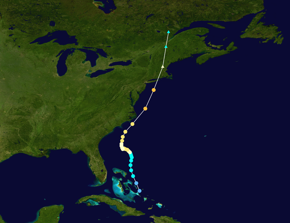
it will be interesting if we see a hurricane come up on this path in September.
I want a 1944 style pattern, hot with many 90 degree days and a few 100 degree days (my favorite early period summer) followed by a Cat 2 hurricane near the first day of fall. I could see a hurricane tracing that exact path to landfall in the middle of Long Island this fall.
-
 1
1
-
-
1 hour ago, LongBeachSurfFreak said:
That’s my theory. This time of year there is a huge temperature difference at the north wall of the Gulf Stream. From 80 degree water to 50s in a matter of miles. And the convection seems to fire just to the north west of the north wall.
we keep having these heavy bouts of tropical rainfall interspersed with dry periods, we just had another one.
-
19 minutes ago, LongBeachSurfFreak said:
Pretty amazing that it has such a similar look on the radar from the last event. Maybe 30 miles west. Almost like atmospheric recall.
One positive is that now both weekend days are forecast to be dry. So this will be gone by tomorrow morning.
-
19 minutes ago, LongBeachSurfFreak said:
Pretty amazing that it has such a similar look on the radar from the last event. Maybe 30 miles west. Almost like atmospheric recall.
Does it have anything to do with the gulf stream?
We just had another bout of heavy rain a few minutes ago.
-
13 minutes ago, bluewave said:
The jet stream weakening after the winter and plenty of blocking in Canada allowing lows to cutoff underneath.
it sounds like this would also lead to cooler summers.
so we are getting +nao in the winter and -nao in the spring and summer.
Based on this alone I would forecast a +nao next winter with snowfall under 20 inches
the more rain and blocking we get now and into summer the less cold and snow we will have in the winter.
It's a formula that has worked for decades.
-
19 minutes ago, LongBeachSurfFreak said:
Flagstaff is a great spot. Super high though, like altitude sickness high.
90 degree days in the summer and 90 inch snowfall in the winter and the added bonus of being ecologically friendly and not a light pollution mecca like the east coast is.
https://en.wikipedia.org/wiki/Flagstaff,_Arizona
Dark Sky City
[edit]Flagstaff takes one of its nicknames from its designation as the world's first International Dark Sky City, with deliberate measures to reduce light pollution beginning in 1958[139] supported by the environmentally-aware population and community advocates, government and elected officials, and the assistance of observatories in the area – including the United States Naval Observatory Flagstaff Station and Lowell Observatory.[140][141][142][143]
The city's designation as an International Dark Sky City was on October 24, 2001, by the International Dark-Sky Association, after a proposal by the Flagstaff Dark Skies Coalition to start the recognition program. It is seen as a world precedent in dark sky preservation.[144] Before this, it had been nicknamed the "Skylight City" in the 1890s, the same decade that the Lowell Observatory was founded.[145] In 1958, it passed Ordinance 400,[139] which outlawed using large or powerful searchlights within city limits. In the 1980s a series of measures were introduced for the city and Coconino County, and the Dark Sky Coalition was founded in 1999 by Chris Luginbuhl and Lance Diskan. Luginbuhl is a former U.S. Naval astronomer,[146] and Diskan had originally moved to Flagstaff from Los Angeles so that his children could grow up able to see stars, saying that "part of being human is looking up at the stars and being awestruck."[145] It was reported that even though greater restrictions on types of public lighting were introduced in 1989,[147] requiring them all to be low-emission, some public buildings like gas stations hadn't updated by 2002, after the Dark Sky designation.[148]
Flagstaff and the surrounding area is split into four zones, each permitted different levels of light emissions. The highest restrictions are in south and west Flagstaff (near NAU and its observatory), and at the Naval, Braeside, and Lowell Observatories.[56] Photographs detecting emissions taken in 2017 show that Flagstaff's light is 14 times less than another Western city of comparable size, Cheyenne, Wyoming, which Luginbuhl described as "even better than [they] might have expected".[146]
-
10 minutes ago, gravitylover said:
There's a property somewhere in Arizona just waiting for you...
too many spiders/scorpions/snakes/lizards (although no light pollution is really good.) Flagstaff would be a dream, snowy in the winter, dry and hot in the summer and a certified dark city with very low light pollution.
the space heater works just fine heating everything up and drying it out, I have it set to 83 degrees now.
-
 1
1
-
-
17 minutes ago, LongBeachSurfFreak said:
The rain should make you’re allergies temporarily better as it knocks the pollen out of the air. Maybe you have some mold issues too?
turning on my space heater actually stopped the allergies (for now anyway).
-
 1
1
-
-
Danbury received 1" of snow on May 9 1977 and Hartford received 1.3"-- these are the latest snowfalls on record for both locations.
For the entire state of CT it's Litchfield on May 29 1909 when 4.6 inches fell there.
-
 1
1
-
-
1 minute ago, LongBeachSurfFreak said:
The rain should make you’re allergies temporarily better as it knocks the pollen out of the air. Maybe you have some mold issues too?
Yes it's mostly mold lol, my allergies act up just before it starts to rain, so last night was really bad and this morning. Maybe now it will be better because the rain should wash the spores out of the air.
I don't have these when it's sunny and dry (although the wind makes it act up too.)
-
10 minutes ago, 40/70 Benchmark said:
It was def. a really good winter, but probably outside of my top 5...especially considering how I badly I got porked in PD II.
It must have been very close, because Boston had one of their highest snowfall totals in PD2.
-
8 minutes ago, 40/70 Benchmark said:
It was def. a really good winter, but probably outside of my top 5...especially considering how I badly I got porked in PD II.
PS this is the anniversary of the famous May 9-10, 1977 snowstorm!!
The latest I have ever seen snow also occurred on this date -- May 9, 2020 -- a Trace of snow with a temperature of 34 in NYC but in the Poconos where I was for that storm, 4 inches with temps in the upper teens and wind chills near 0!
-
15 minutes ago, SACRUS said:
wow and a NESIS map to boot! 7-8 inches in NE PA and a Trace all the way down to Cape May NJ!


2024-2025 La Nina
in Weather Forecasting and Discussion
Posted
carbon dioxide is treated like a villain but it's water vapor that is the real culprit (a worse greenhouse gas and an air pollutant to boot.) If we could remove about 30% of the water vapor out of the atmosphere and convert it to drinking water, this would go a long ways towards fixing CC and our fresh drinking water problems.
I hate water vapor so I'm all aboard this train.