-
Posts
42,229 -
Joined
Content Type
Profiles
Blogs
Forums
American Weather
Media Demo
Store
Gallery
Posts posted by LibertyBell
-
-
5 minutes ago, SACRUS said:
Just as important
ear Rank Days >= 80 °F 2015 1 118 2024 2 117 2021 3 116 1994 4 114 2016 5 113 1993 5 113 1991 5 113 2011 8 111 2010 8 111 2023 10 110 2022 11 109 1959 12 108 2007 13 106 2005 14 105 2002 15 104 1990 16 103 1957 16 103 1983 18 102 1906 18 102 1989 20 101 1986 20 101 1949 20 101 1908 20 101 2019 24 100 2017 24 100 2018 26 99 2013 26 99 2001 26 99 2008 29 98 1998 29 98 1944 29 98 2020 32 97 2012 32 97 Look at 1944, 1949 and 1959 putting in such strong performances on all standings! 1953 putting in a strong performance on number of 100 degree days.
I knew we had some real roasters back then but this is very extreme.
-
1 minute ago, SACRUS said:
wow this is so much closer than I thought..... 1944 and 1949 putting in a great performance on all standings..... 8 100 degree days in 1949 is absolutely WILD, 1993 just barely edged it out with 9 !!
-
3 minutes ago, SACRUS said:
wow thanks Tony, so 1993 still has a sizeable lead in 95 and 100 degree days.
So basically you could rank them as such: 1993, 2010 and 2022 as the top three summers at Newark.
-
Just now, SACRUS said:
Thanks, so 2010 still has a decent lead in 90 degree days but 2022 has tied 1993 in 90 degree days. 1993 still has a sizeable lead in 100 degree days (9), but I'm not sure what their 95 degree tally was.
There's a big separation after the top 3.
-
25 minutes ago, bluewave said:
95° and 100° days were close in 2022 to 2010 in NJ.
2022 95° days
Data for January 1, 2022 through December 31, 2022
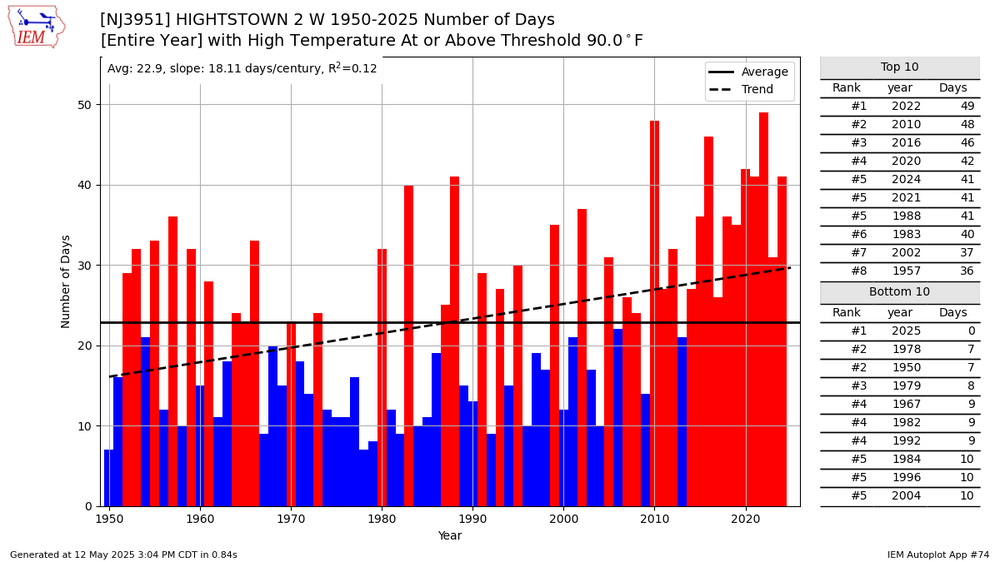
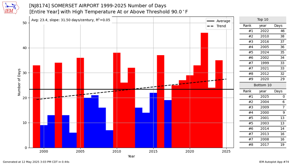
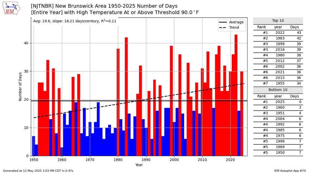
Click column heading to sort ascending, click again to sort descending.Newark Area ThreadEx 20 NEWARK LIBERTY INTL AP WBAN 20 FREEHOLD-MARLBORO COOP 16 HARRISON COOP 16 SOUTH JERSEY REGIONAL AIRPORT WBAN 16 CANOE BROOK COOP 14 LONG BRANCH-OAKHURST COOP 13 SOMERSET AIRPORT WBAN 13 HIGHTSTOWN 2 W COOP 12 INDIAN MILLS 2 W COOP 10 NEW BRUNSWICK 3 SE COOP 10 CALDWELL ESSEX COUNTY AP WBAN 10 ESTELL MANOR COOP 10 New Brunswick Area ThreadEx 10 MANASQUAN 1 NW COOP 10
NJ 100° days
Data for January 1, 2022 through December 31, 2022
Click column heading to sort ascending, click again to sort descending.NEWARK LIBERTY INTL AP WBAN 6 Newark Area ThreadEx 6 SOMERSET AIRPORT WBAN 5 FREEHOLD-MARLBORO COOP 5 CANOE BROOK COOP 4 HARRISON COOP 4
2010 95° daysData for January 1, 2010 through December 31, 2010
Click column heading to sort ascending, click again to sort descending.WRIGHTSTOWN COOP 24 SOMERDALE 4 SW COOP 22 Newark Area ThreadEx 21 NEWARK LIBERTY INTL AP WBAN 21 MOORESTOWN 4 E COOP 19 ATLANTIC CITY INTL AP WBAN 18 Atlantic City Area ThreadEx 18 CANOE BROOK COOP 18 RINGWOOD COOP 18 ESTELL MANOR COOP 18 TRENTON-MERCER AIRPORT WBAN 17 Trenton Area ThreadEx 17 HARRISON COOP 16 SOUTH JERSEY REGIONAL AIRPORT WBAN 16 PENNSAUKEN 1N COOP 16 FREEHOLD-MARLBORO COOP 15 NEW BRUNSWICK 3 SE COOP 15 New Brunswick Area ThreadEx 15
2010 100° daysData for January 1, 2010 through December 31, 2010
Click column heading to sort ascending, click again to sort descending.Newark Area ThreadEx 4 WRIGHTSTOWN COOP 4 NEWARK LIBERTY INTL AP WBAN 4 HARRISON COOP 4 Trenton Area ThreadEx 3 FREEHOLD-MARLBORO COOP 3 TRENTON-MERCER AIRPORT WBAN 3 CANOE BROOK COOP 3 RINGWOOD COOP 3 SOMERDALE 4 SW COOP 3 that's interesting, 2022 never got the publicity that 2010 did for being very hot, probably because 2010 was hotter over a much larger area.
It's like February 2006, a HECS for a small area, vs January 2016, a HECS over a much larger area.
What were 1993 numbers for Newark, just for reference, for 95 and 100 degree days?
-
4 minutes ago, Brian5671 said:
it will have a tough time moving in at all especially N and E of the city-alot of dry air
Good, we don't need any more rain.
-
4 minutes ago, bluewave said:
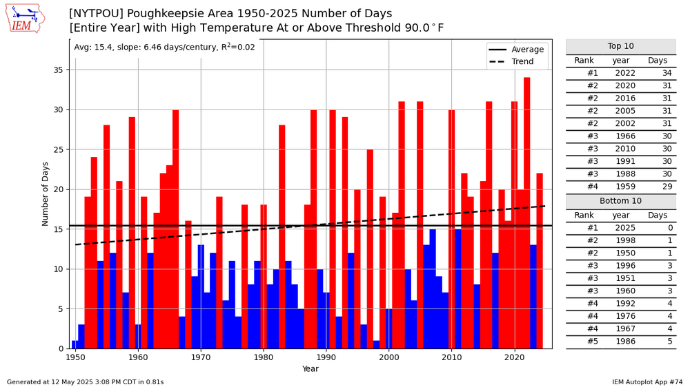
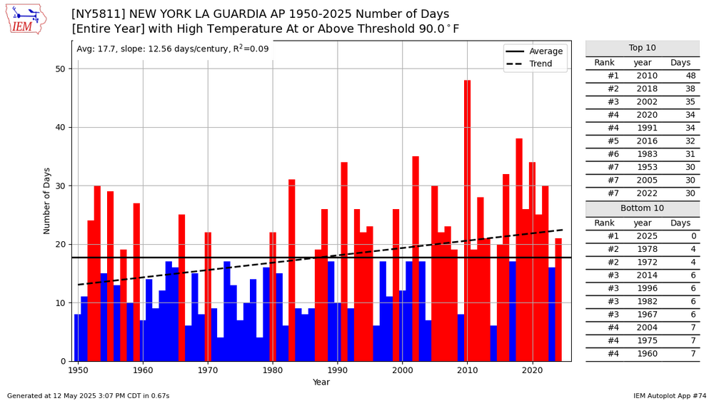
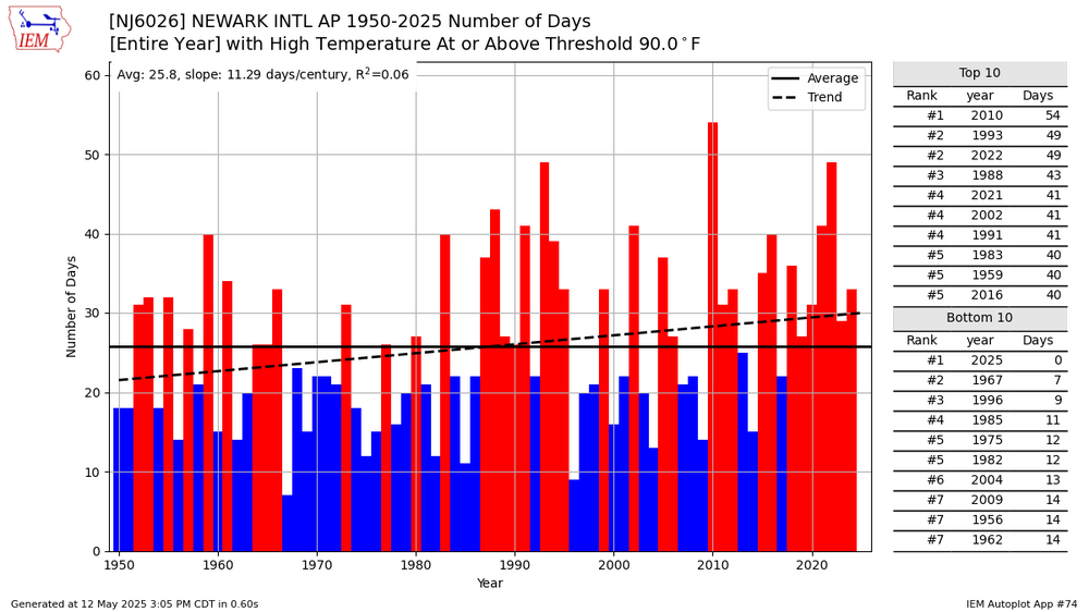
Of course 90° days are increasing in the city. I showed you how the drop in 90° days is a function of measuring the temperatures under the trees in Central Park since 1995. Several areas had their warmest summer on record for 90° days as recently as 2022.
The immediate South Shore isn’t representative of what most of this forum experiences in the summer. This is a function of the ridge extending east of New England and turning the flow more onshore. So the sea breeze fronts have been setting up north of JFK and the Southern State Parkway on Long Island. Very rare in recent years for the sea breeze fronts to remain along the South Shore beaches like they did from the 1990s to 2013.
2022 was nowhere near as hot as 2010 was, which was our heat benchmark. You can even look at the number of 95 degree days and 100 degree days and we have not had anything like that since. And 1993 had 9 100 degree days at Newark, which has not come close to being matched.
-
7 minutes ago, bluewave said:
90° days have been increasing across the entire region. The only areas that haven’t seen a big increase are at near the immediate shore. But most people live away from the immediate shore areas.
It's not increasing in the city either. Furthermore we have not seen any of the lengthy heatwaves I cited earlier since 2002. I think if we look at a population density map, we'll find that most people actually do live near the shore-- by shore I mean Brooklyn, Southern Queens, south shore of Long Island, etc. The population density is less the further away from the ocean that you go.
It's not just the immediate shore. Increasing rainfall is the major reason why we don't see lengthy heatwaves like we used to and until the rainfall goes down, that won't change.
-
3 minutes ago, LongBeachSurfFreak said:
Yeah the rest of the week looks like crap. Hopefully we can salvage at least some of Memorial Day weekend but the pattern isn’t conducive for beach weather either way.
Memorial Day weekend is a long way off, I could see any rain being suppressed to our south by then.
-
2 hours ago, Dark Star said:
It really doesn't matter. We use all historical data for the minimum/maximum records for any specific date, but only use the previous 20-30 year average for the day's average temperatures? When people hear heat index temperatures, or wind chill, they think that is the actual temperature, so, it really doesn't matter,because all the really good looking girls would still go out with the guys from Mohawk cause they've got all the money!
I read this wrong
because all the really good looking girls would still go out with the guys with a Mohawk cause they've got all the money!
-
2 hours ago, Stormlover74 said:
Models seem to be showing about an inch of rain this week particularly nyc on south and west which would give areas that still need some rain a good soaking
Yes south Jersey and southeast PA really need it.
-
34 minutes ago, LongBeachSurfFreak said:
Just took a nice 6 mile walk right on the ocean at Jones Beach. Senior cut day with kids running in and out of the water. Gorgeous beach day if you don’t mind a little bite in the east wind.
Gorgeous day, the clouds have held off.
Not going to see another one like this until next Sunday?
-
2 hours ago, Sundog said:
The increased water vapor has really jacked up our average dewpoint which is like a natural cap to very high temps.
One of these years we are going to get strong, dry westerly winds in a heatwave and we are going to set very high temperature records.
I hope and wish lol.
The longest heatwaves page the NWS has up for NYC really puts things into perspective. I think NYC LGA EWR and JFK all had their longest heatwaves in 1953, 1993 and 1999.
-
49 minutes ago, Brian5671 said:
If anyone truly believes we haven't warmed in the last 20 yrs they need to get their head checked...
it's a nuanced argument that can presented many different ways.
of course it's warming but....
1) winters are warming much more quickly than summers are
2) summer high temps are capped by the planet self regulating the excess heat by dumping it into the ocean, thus we're not getting the higher number of 90 degree days that we used to.
3) if you go by averages it does not matter either way, since mins are going up much faster than the maxes are.
4) the way I define heat as in number of 90 and 100 degree days and length of heat waves is only going up for areas well inland.
-
49 minutes ago, bluewave said:
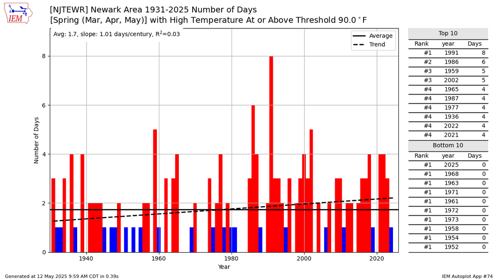
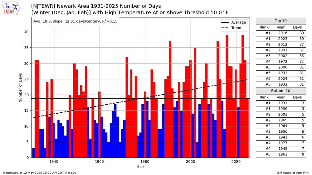
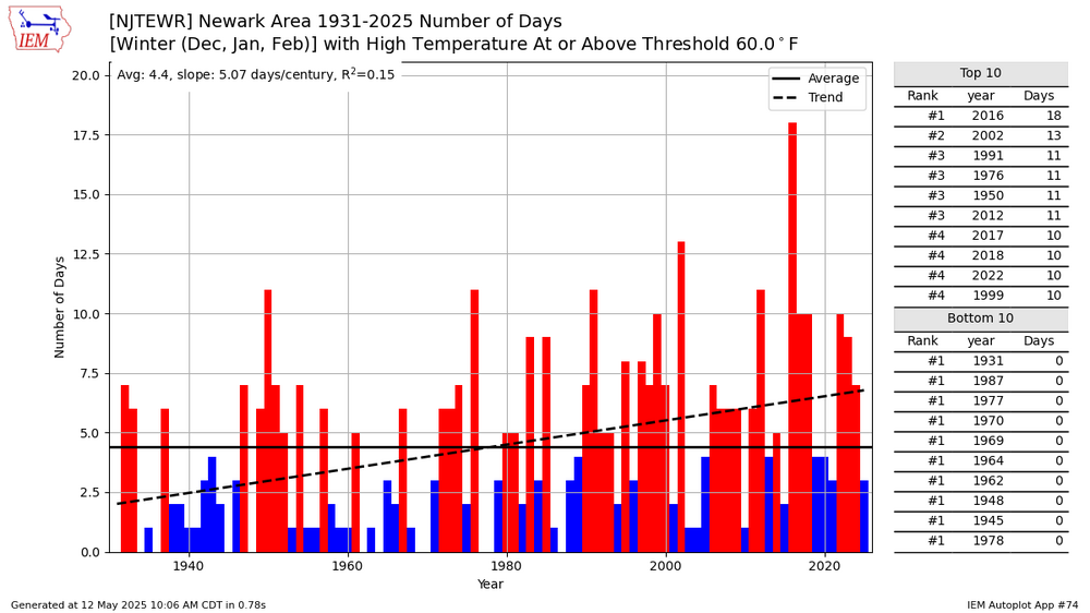
Yeah, spring 90° days at Newark have been increasing at a much slower rate than 50° and 60° days during the winter.
1991 and 1993 were two of our hottest summers on record so it's not a surprise to see we had many more 90 degree days back then.
-
1 hour ago, SACRUS said:
EWR most 90 degree days in May was 6 in 1991.
That was one of our hottest summers on record, which more of them happened in the 90s than any other decade.
-
1 hour ago, SACRUS said:
Records:
Highs:
EWR: 92 (1959)
NYC: 93 (1881)
LGA: 88 (1991)
JFK: 89 (1991)
Lows:
EWR: 40 (1938)
NYC: 40 (1907)
LGA: 43 (1940)
JFK: 43 (2020)
Historical:1760: Ben Franklin was the first person to identify nor'easters. In a letter on this date, Franklin described an experience that happened to him in November 1743 when storm clouds in Philadelphia blocked his view of an eclipse. Franklin assumed that the storm had blown in from the northeast because the surface winds at his location were from that direction. He was puzzled to find out later that his brother had viewed the eclipse with no problems and that the storm had arrived in Boston four hours later. The information caused Franklin to correctly surmise that the storm had moved from southwest to northeast.
1834: Unusual snows occurred across the Northeast. 6 inches fell at Erie, PA and 12 inches at Rutland, VT from this date through the 15th.
1876: The first American newspaper weather map was published in the New York Herald. Weather maps would first appear on a regular basis beginning on May 9, 1879 in the New York Daily Graphic.
1934 - A dust storm darkened skies from Oklahoma to the Atlantic coast. (David Ludlum)
1971 - Duststorms suddenly reduced visibilities to near zero on Interstate Highway 10 near Casa Grande AZ. Chain reaction accidents involving cars and trucks resulted, killing seven persons. (The Weather Channel)
1972 - In Texas, A cloudburst dumped sixteen inches of rain north of New Braunfels sending a thirty foot wall of water down Blueders Creek into the Comal and Guadalupe Rivers washing away people, houses and automobiles. The flood claimed 18 lives and caused more than twenty million dollars damage. (The Weather Channel)
1982 - A late season snowstorm struck the Front Range of the Colorado Rockies. The storm produced 46 inches of snow at Coal Creek Canyon, located near Boulder. (David Ludlum)
1987 - A heat wave persisted in central California. Afternoon highs of 100 degrees at Fresno CA and 102 degrees at Sacramento CA were records for the date. (The National Weather Summary)
1988 - Unseasonably warm weather prevailed in the western U.S. Eight cities reported record high temperatures for the date, including Pendleton OR with a high of 92 degrees and Phoenix AZ with a reading of 106 degrees. (The National Weather Summary)
1989 - Showers and thunderstorms associated with a low pressure system stalled over New York State drenched Portland ME with 4.50 inches of rain in 24 hours. Rains of 5 to 7 inches soaked the state of Maine over a four day period causing 1.3 million dollars damage. (The National Weather Summary) (Storm Data)
1990 - Thunderstorms produced severe weather from eastern Texas and the Central Gulf Coast States into Missouri and Illinois. Thunderstorms spawned six tornadoes, including one which injured four persons at Doloroso MS. Thunderstorms also produced hail three inches in diameter west of Vicksburg MS, and wind gusts to 83 mph in southern Illinois, north of Vevay Park and at the Coles County Airport. High winds and heavy rain caused 1.6 million dollars crop damage in Calhoun County IL, and in southeastern Louisiana, Saint Joseph was deluged with eight inches of rain. (The National Weather Summary) (Storm Data)
1760: Ben Franklin was the first person to identify nor'easters. In a letter on this date, Franklin described an experience that happened to him in November 1743 when storm clouds in Philadelphia blocked his view of an eclipse. Franklin assumed that the storm had blown in from the northeast because the surface winds at his location were from that direction. He was puzzled to find out later that his brother had viewed the eclipse with no problems and that the storm had arrived in Boston four hours later. The information caused Franklin to correctly surmise that the storm had moved from southwest to northeast.
It would be interesting to find out if this was a lunar or a solar eclipse?
-
-
5 minutes ago, Dark Star said:
Perhaps local major media "meteorologists" should climb aboard and not use Central Park temps? I know, wishful thinking...
their wind speeds are also too low and by a wide margin
-
 1
1
-
-
1 minute ago, Brian5671 said:
We have the same issue here-Bridgeport's stats come from an airport on a peninsula that sticks out into the sound-it's routinely 55 there and 70 just a few miles inland....in the winter much warmer than surrounding areas-not really representative of what most people experience sensible weather wise.
snowfall totals seem to be off too
-
 1
1
-
-
1 hour ago, 40/70 Benchmark said:
We must be turning into a tropical rain forest this decade.
Yes, way too much rain in the summer. Fall was very dry, but usually a dry fall is a bad sign as it hints at what the winter will be like.
Some great winters after hot and dry summers 1955-56, 1966-67, 1977-78, 1993-94, 1995-96, 2002-03, 2010-11. This is a very nice list....
-
12 minutes ago, bluewave said:
Less wet would be so much better, today is absolutely perfect.
I have my suspicions that the *wet* pattern won't be as wet as these forecasts because it really goes against climo and what we've been seeing for many months now. We might see a few less than one inch rainfall events, like we have been, but nothing big.
-
1 hour ago, Yanksfan said:
I know it’s way early in the game for a legit call on next winter, but thus far I’m not liking all this negativity. I’m not looking for a blockbuster season; just give me a normal winter at this point.
I have a fairly easy rule of thumb I use that seems to work well. If the summer is hot and dry it will be a snowy cold winter. If summer is rainy and not so hot, then the winter will have very little snowfall or cold.
-
22 minutes ago, 40/70 Benchmark said:
Descending is worse than solar max for the NAO, so that isn't going to help....not saying that you were implying it would....just as an addendum.
any idea why it's worse Ray?




May 2025
in New York City Metro
Posted
Don, when will the clouds move in make our skies overcast? No sun from tomorrow through Saturday?