-
Posts
42,229 -
Joined
Content Type
Profiles
Blogs
Forums
American Weather
Media Demo
Store
Gallery
Posts posted by LibertyBell
-
-
14 minutes ago, Brian5671 said:
The question is do you get any more or is that it?
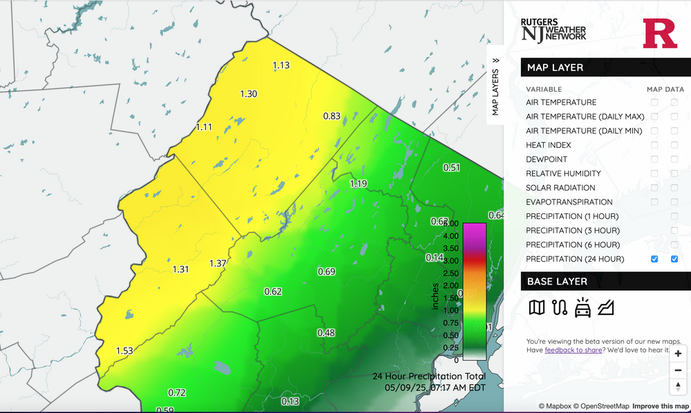
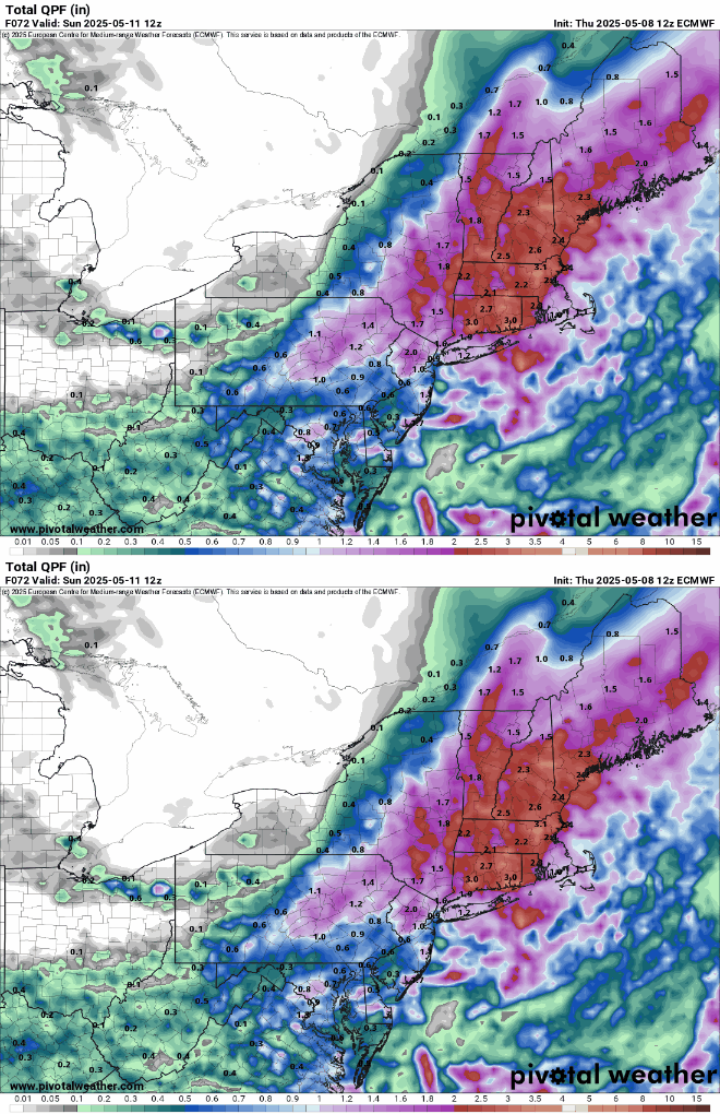
This is more than enough rain, looks like it's going to be mostly dry this afternoon and maybe even some sunny breaks just before sunset.
My allergies are acting up now so I know we've had more than enough rain.
-
2 minutes ago, jm1220 said:
We’ll see, hopefully it’s right. Could be a brief heavy rain batch here while eastern Suffolk gets drenched with the stuff off the NJ coast.
it's raining here now but more moderate than heavy.
-
19 minutes ago, 40/70 Benchmark said:
I'm not sure...I'm speculating. I never said every season has been +NAO, but as you stated...the trend has been strongly in favor of +NAO.
and Spring has been tending to -NAO (especially April and May ugh!!)
-
20 minutes ago, 40/70 Benchmark said:
Eh...depends on perspective. I'd rake 2000-2001 over 2002-2003, and I think many in the mid atl would take 2009-2010.
There are three criteria I use to rate A+ winters (this is going to be very unscientific lol)
1. Holiday Snow (2002-03 had that and on Christmas Day to boot!)
2. HECS for the entire DC to Boston corridor (PD2).
3. An April snowstorm (April 2003).
Only two A+ winters for my area in my lifetime 1995-96 and 2002-03.
-
23 minutes ago, LongBeachSurfFreak said:
Yeah that’s what I was thinking. Norwalk is low elevation right near the coast. Norfolk the opposite.
Also the rain just started here and it's pretty heavy!!
-
20 minutes ago, wdrag said:
Yep, much more needed there than here, Walt. Eastern PA is also going to get a lot of rain (they had 3.6 inches with the last event in the Poconos too.)
-
 1
1
-
-
26 minutes ago, SACRUS said:
Records:
Highs:
EWR: 93 (2000)
NYC: 94 (1979)
LGA: 92 (2000)
JFK: 86 (2000)Lows:
EWR: 33 (1947)
NYC: 3 (2020)
LGA: 36 (2020)
JFK: 34 (2020)
Historical:1894: Portland, OR had its latest freeze when the temperature fell to 32°. This is the only May freeze in Portland's history.
1966 - Record snows fell in the northeastern Ohio and western Pennsylvania, including 3.1 inches at Pittsburgh PA and 5.4 inches at Youngstown OH. Snow also extended across parts of New York State, with eight inches reported in the southern Adirondacks. (The Weather Channel)
1977 - A late season snowstorm hit parts of Pennsylvania, New York State, and southern and central New England. Heavier snowfall totals included 27 inches at Slide Mountain NY and 20 inches at Norwalk CT. At Boston it was the first May snow in 107 years of records. The heavy wet snow caused extensive damage to trees and power lines. The homes of half a million persons were without power following the storm. (9th-10th) (David Ludlum) (The Weather Channel)
1985 - Lightning struck some trees about 150 yards away from a home in Alabama, and followed the driveway to the home. The charge went through the house and burned all the electrical outlets, ruined appliances, and blasted a hole in the concrete floor of the basement. (The Weather Channel)
1987 - Unseasonably warm weather spread from the Pacific Northwest to the Upper Mississippi Valley. Fifteen cities reported record high temperatures for the date. It was the fourth day of record warmth for Eugene OR and Salem OR. (The National Weather Summary)
1988 - A massive cyclone in the central U.S. produced severe thunderstorms from eastern Texas to the Upper Ohio Valley. A strong (F-3) tornado ripped through Middleboro KY causing more than 22 million dollars damage. Thunderstorms in east central Texas produced hail three and a half inches in diameter at Groesbeck, and near Fairfield. (The National Weather Summary) (Storm Data)
1989 - Thunderstorms developing ahead of a cold front in the south central U.S. produced golf ball size hail and wind gusts to 62 mph at Mira LA, and during the morning hours drenched Stuttgart AR with five inches of rain. (The National Weather Summary) (Storm Data)
1990 - Thunderstorms produced severe weather in the central U.S. during the evening hours, mainly from southeastern Missouri to southwestern Indiana. Severe thunderstorms spawned four tornadoes, including two strong (F-2) tornadoes in southern Illinois. Strong thunderstorm winds gusted to 85 mph at Orient IL, and to 100 mph at West Salem. Thunderstorms drenched northeastern Illinois with up to 4.50 inches of rain. (The National Weather Summary) (Storm Data)
Tony what was the record low on this date in 2020 at NYC.... you wrote 3.
-
19 minutes ago, bluewave said:
whats causing these semipermanent upper lows, it feels like it's the same one hanging around for weeks.
-
11 minutes ago, LongBeachSurfFreak said:
20” at Norwalk seems highly sus.
This is also the anniversary of the May 2020 snow.
There was 7" at Providence RI in the May 1977 event and over a foot in the Poconos (13-17 inches.) In the May 2020 event we had 2-4 inches in the Poconos over a two day period with temperatures falling into the upper teens and wind chills near 0.
That 20" in Norwalk might be a typo for Norfolk, CT, which is in the Litchfield Hills in CT and the snowiest spot in the state.
1977 - A late season snowstorm hit parts of Pennsylvania, New York State, and southern and central New England. Heavier snowfall totals included 27 inches at Slide Mountain NY and 20 inches at Norwalk CT. At Boston it was the first May snow in 107 years of records. The heavy wet snow caused extensive damage to trees and power lines. The homes of half a million persons were without power following the storm. (9th-10th) (David Ludlum) (The Weather Channel)
-
21 minutes ago, LongBeachSurfFreak said:
Yeah I could see the east end getting crushed again while further west gets slotted. We had that super persistent area of convection off the Jersey Shore with the last event too. Must be some sort of feedback with a Gulf Stream eddy.
the Gulf Stream.
I'm looking forward to a very nice weekend!
-
9 hours ago, Stormchaserchuck1 said:
I was using DJFM, but it's interesting to see that there's still only 1 example in 14 years, using DJF. +0.25 is not that much.
There isn't NAO data from the 1930s, but imo the 1930s through early 1950s were probably more +NAO.
with some small exceptions like 1933-34, 1942-43, 1947-48. Those were some very cold/snowy winters!!
-
9 hours ago, Stormchaserchuck1 said:
I'm not so sure the NAO is tied to CC. Why have other seasons had -NAO's, some strong -NAO? The Winter NAO state for the last 14 years is a bit of an anomaly, because it hasn't happened that way in other seasons.
Don't get me wrong, I would say the trend is warmer and less snowy, but that N. Atlantic pressure index has not been favorable.
With more global precipitable water now though, I think a -NAO these days would be less dry than several decades ago.
-NAO is now shifting to MAM while +NAO predominates in DJF.
Actually scratch March, now DJFM are all +NAO while -NAO is now AM
-
14 hours ago, bluewave said:
It may turn out to be another case of the record WPAC warm pool driving the La Niña background more than what is occurring in the traditional ENSO regions east of the Dateline.
isn't this why we've been having so many multiyear la ninas?
-
On 5/7/2025 at 3:29 PM, GaWx said:
Thanks, Ray. I also wonder about CC’s effect.
-Don’t forget 2009-10-Including March actually brings 2012-13 into the list due to the -1.61 in March making DM average -0.39
-Including March would take 2020-1 out for me because DM averaged only -0.14, which I call neutral
-Based on DJF, I have 2009-10, 2010-11, and 2020-21. Based on DJFM, I have 2000-01, 2009-10, 2010-11, and 2012-13.
remember we don't really need a -NAO, 2002-03 was better than any of those winters and had a near neutral NAO.
-
4 hours ago, LongBeachSurfFreak said:
Perfect weather on the south shore. Deep blue sky and temps around 70.
It was nice to go two days with blue skies and no rain.
-
32 minutes ago, bluewave said:
The strong onshore flow kept the upper 80s heat to our West.
for May 1, 2025 through May 7, 2025
Click column heading to sort ascending, click again to sort descending.OCEAN COUNTY AIRPORT WBAN 89 Newark Area ThreadEx 88 NEWARK LIBERTY INTL AP WBAN 88 HARRISON COOP 88 TETERBORO AIRPORT COOP 87 TETERBORO AIRPORT WBAN 87 ESTELL MANOR COOP 87 SOMERSET AIRPORT WBAN 86 PHILADELPHIA/MT. HOLLY WFO COOP 86 New Brunswick Area ThreadEx 86 HIGHTSTOWN 2 W COOP 86 NEW BRUNSWICK 3 SE COOP 86 CALDWELL ESSEX COUNTY AP WBAN 86 Atlantic City Area ThreadEx 85 PENNSAUKEN 1N COOP 85 MILLVILLE MUNICIPAL AIRPORT WBAN 85 ATLANTIC CITY INTL AP WBAN 85 MOORESTOWN 4 E COOP 85 FREEHOLD-MARLBORO COOP 85 EWING 3 WNW COOP 85 FLEMINGTON 5 NNW COOP 85 SOUTH JERSEY REGIONAL AIRPORT WBAN 85 Trenton Area ThreadEx 84 MARGATE COOP 84 MANASQUAN 1 NW COOP 84 LONG BRANCH-OAKHURST COOP 84 TRENTON-MERCER AIRPORT WBAN 84 SUSSEX AIRPORT WBAN 83 CHARLOTTEBURG RESERVOIR COOP 83 SCHOOLEY'S MOUNTAIN 1 SW COOP 81 BOONTON 1 SE COOP 81 HIGHLAND LAKES 1SW COOP 80 Data for May 1, 2025 through May 7, 2025
Click column heading to sort ascending, click again to sort descending.NJ NEWARK LIBERTY INTL AP WBAN 88 NJ HARRISON COOP 88 NY LAGUARDIA AIRPORT WBAN 87 NJ TETERBORO AIRPORT WBAN 87 NJ TETERBORO AIRPORT COOP 87 NJ CALDWELL ESSEX COUNTY AP WBAN 86 NY NY CITY CENTRAL PARK WBAN 85 NJ CHARLOTTEBURG RESERVOIR COOP 83 NY SHRUB OAK COOP 83 NY WESTCHESTER CO AP WBAN 83 NY PORT JERVIS COOP 82 NY MONTGOMERY ORANGE COUNTY AP WBAN 82 CT DANBURY MUNICIPAL AP WBAN 82 NY CENTERPORT COOP 82 NY PORT AUTH DOWNTN MANHATTAN WALL ST HEL ICAO 81 NY BAITING HOLLOW COOP 81 CT MERIDEN MARKHAM MUNICIPAL AP WBAN 81 CT OXFORD WATERBURY WBAN 79 NY SYOSSET COOP 79 CT NORWICH PUBLIC UTILITY PLANT COOP 79 NY RIVERHEAD RESEARCH FARM COOP 78 NY JFK INTERNATIONAL AIRPORT WBAN 77 NY ST. JAMES COOP 76 NY ISLIP-LI MACARTHUR AP WBAN 76 NY FARMINGDALE REPUBLIC AP WBAN 75 NY SHIRLEY BROOKHAVEN AIRPORT WBAN 75 NY UPTON COOP - NWSFO NEW YORK COOP 75 CT NEW HAVEN TWEED AP WBAN 74 CT IGOR I SIKORSKY MEMORIAL AIRPORT WBAN 73 CT GUILFORD COOP 73 NY ORIENT POINT STATE PARK COOP 72 NY BRIDGEHAMPTON COOP 71 CT DANBURY COOP 70 NY WESTHAMPTON GABRESKI AP WBAN 70 wow Ocean County Airport-89- is that Toms River?
-
6 minutes ago, bluewave said:
I remember this was the case in summer 1995, it's why the Mississippi River valley was so wet with the ring of fire surrounding us, August 1995 was historically dry because of it.
-
2 hours ago, Hitman said:
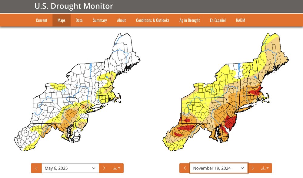
Still in D1 even after the 2"+ of precipitation from the latest system. Supposedly due to low stream flow and ground moisture. Not the case in my area. There is a stream (Furnace Brook) that runs through my property and it is anything but low. More like roaring or raging.
Makes me skeptical of how they calculate this stuff.
I'm more of an *in the moment* kind of guy, if the rainfall for the month (and even moreso the season) is above normal, it's above normal. Even the reservoirs are over 100%
-
3 hours ago, Picard said:
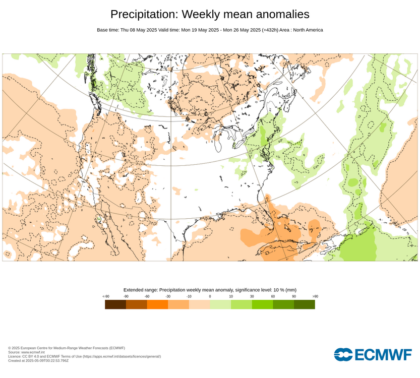
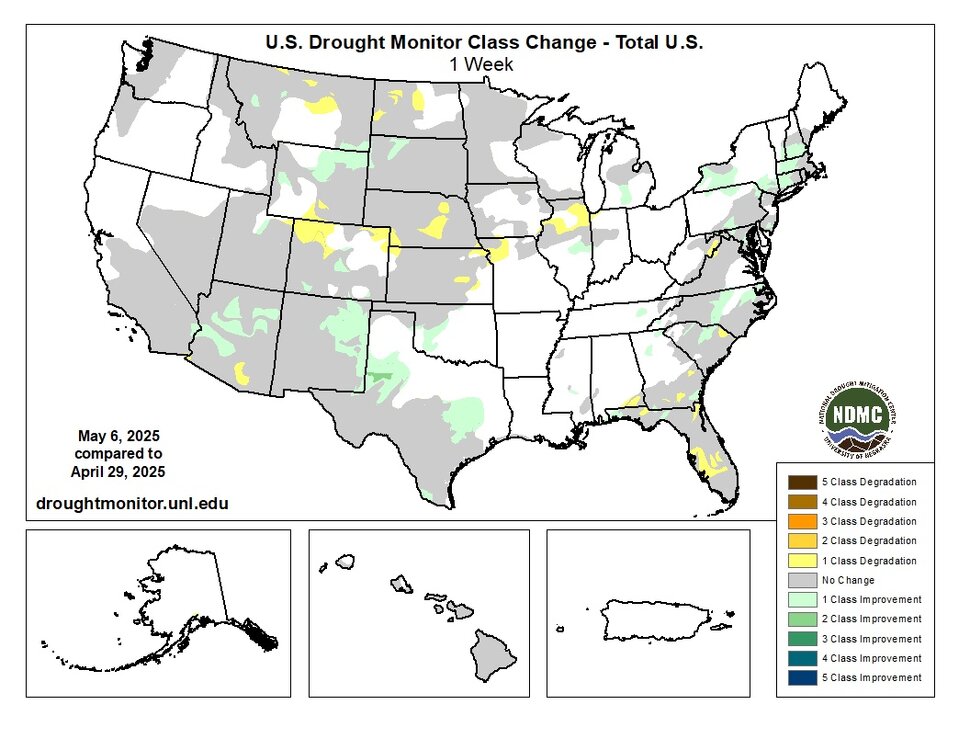
I remain skeptical of calls for a wetter pattern. While I agree that there are things that may point to it, often times we see much of the precipitation off to the north and west or hook around and out of the area entirely. This has been a trend for month after month now. The latest drought monitor is out, which shows modest improvements in the more severe drought areas for NJ, but much of the more pronounced improvements in the northeast are all over central PA as well as central and western NY State.
This is to be expected with a strong southeast ridge, usually north and west areas do better with rainfall.
-
3 hours ago, bluewave said:
Top 5 warmth across the area for the 1st week of May.
EWR…5th warmest
LGA….5th
HPN….5th
JFK….5th
ISP…..4th
BDR….5th
PHI…..5th
This is weird with no hot or even very warm days at all (it hasn't hit 80 at JFK from what I recall.)
-
-
4 hours ago, bluewave said:
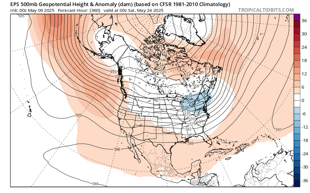
Unfortunately, the Pacific Jet has been too strong during the winter. So as the gradient weakens further into the spring, the weaker jet isn’t able to act as a kicker. So these closed lows get stuck in place when people are ready for sunny spring weather. But the good news is that the northern edge of the drought areas to the north of I-80 and into CT has improved with the soaking rains there in recent days.
But aren't we supposed to have stronger SE ridges too? Those generally establish a ring of fire that keeps the storminess to our north and west.
-
2 hours ago, LongBeachSurfFreak said:
I fully agree in the short term. When we cross the 2c threshold and the negative consequences become so glaringly obvious there will be across the board support for change. When sea level rises another 3 feet you start inundating extremely valuable coastal land. When summer temps are so high in the worlds bread baskets that cereal crops can no longer grow. That’s when the general populace has to wake up. When the destruction of wealth leds the charge. Capitalism is highly flawed in regards to long term greater good tendency. As we currently have the knowledge and tech to prevent most of this from happening.
The good thing is all these things will put a check on human overpopulation in a big way.
Nature always knows best.
-
20 hours ago, csnavywx said:
On geologic timeframes, I agree we're in the last act. It's no longer even possible to get a snowball scenario now, insolation is already too high. The drawdown in GHGs over the last ~300-500Mya has mostly neatly offset the increase in insolation over time but that parameter space is now limited on the downside. I would venture a guess that current continental drift resulting in another supercontinent+2-3% insolation puts temps well above Eocene levels and ends the golden age of habitability.
In either the short or long run, if you pancake the ETP temp gradient with either GHGs or insolation, you kill off most marine life during the transition. If it happens quickly enough, then you can end up with Canfield oceans -- which I would describe as a weird form of undeath (purple water and green atmosphere from euxinic conditions). In the very short run, we're extremely close (450ppm) to tipping over in the Southern Ocean with regards to ocean acidification causing widespread aragonite undersaturation, what I would consider the first step in that process.
we really need to develop interstellar travel.... it's either that or extinction


May 2025
in New York City Metro
Posted
Yeah this is enough rain. I don't want 1+ inches of rain and it looks like whatever we get this morning will be it.