downeastnc
-
Posts
9,343 -
Joined
-
Last visited
Content Type
Profiles
Blogs
Forums
American Weather
Media Demo
Store
Gallery
Everything posted by downeastnc
-
The high placement on the last frame is classic NC snowstorm placement and the snow coverage reacts accordingly......just need the next 2-3 frames now.....
-
Colder and snowier much further east.....now if it will just go ENE from there instead of reforming off the NC coast we would be looking at a bigger event for central and eastern NC but that little jump north kills us.....
-
PGV is 32/18 last frame of the NAM, track kills us though need this thing to stay heading ENE the entire time that turn up the coast is gonna cause problems well inland if it happens....
-
Yeah going NE up the coast from SAV is going to do bad things.....the only people that cash in on that track are the foothill/mts.....the rest of us need a later phase or better yet a slow moving OTS track with a phase well off the SE coast....that track is gonna give the Triad etc ptype issues if it pans out.
-
The one good thing is this thing cant really bust for me.....I would be sweating bullets if I was in the spots showing 12-24" every run.....we had a similar storm forecast down here a few years back, run after run of the Euro and GFS giving us 12-20" in central and eastern NC on the clown maps.....ended up with 3" of sleet......better to expect rain or a slushy 1-2" and get a foot than think your getting the big dog and ending up with tons of sleet. Seriously though if the cold can trend stronger the track should trend flatter and then snow totals would climb in central and eastern NC.....seeing some signs of that on the NAMS etc but still several days to go to hash it out.
-
The jump north with the SLP at 126 on the FV3 is a killer for central and eastern NC, it it just kept ENE from the hr 120 plot the totals from RDU down my way etc would be much higher....
-
Then get use to it cause this is how it is every single time a storm comes around in the SE forum........the same core group post the same way every single model run.......with gaggles of lurkers asking MBY questions......it is what it is.....
-
LOL......you don't have to read the threads this is how we roll in the SE forum we are much less uptight than the folks from other forums......I suggest rolling with the punches or visiting the Sanitarium thread.....or going back to the NYC/MA forums since your in NJ.
-
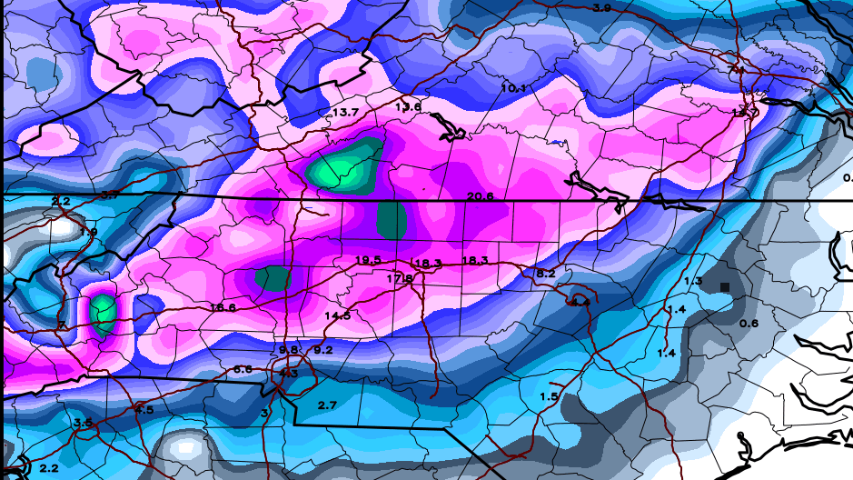
Yeah the whole " you never wanna be in the bullseye 7 days out yada yada yada"....those MA folks probably thinking they have this one right where they want it in the 7-8 day range......the FV-3 track is money until the low gets captured and tugged back into the sounds.........
-
That tornado warning by Oxford the real deal......decent couplet there
-
That onshore firehose band is pummeling areas just south of me....its raining like crazy here and the returns are greens and yellows those areas from Havelock to New Bern to Kinston are just getting hammered.....
-
Everything coming in off the ocean is spinning right now....probably going to be a problem today and even tomorrow
-
B roll footage of New Bern.....unreal https://wcti12.com/news/local/hurricane-damage-from-the-eyewall-destroys-north-carolina-marina
-
Been more tornados spinning up this morning...there are several unwarned rotations ATM and a few that have/are warned ( they happen fast and last a frame or two at best ) as the center drifts WSW those bands will be all over eastern/central NC
-
Thats pretty accurate we gusted 50-60 all night nothing to bad.....takes more than that to drop trees around here lol.....there are a few Bradford Pears mangled etc but over all we have do ok its probably on par with Matthew and considerably less than Irene wind wise....
-
the big story is gonna be surge.....reports that the bridge on Back Creek in Bath is underwater.....to me that is just insane.
-
The eye is 40 miles wide....the plots from recon can be misleading since the eye is so large....the plots they fix dont exactly equal the overall motion sometimes.....it would take Flo 6-8 hrs to cross a given spot.
-
Apparently that was a false report....in the other thread they have the mayor saying its still up......for now....just heard my first transformer blow as I typed this.....
-
Thats on the jetty at Harkers Island...they always get big wind there, I think thats the spot that got the 115 mph gust in Irene....
-
Right but they wobble....its done this all afternoon....averaged out it looks like this.....
-
If this somehow bust north and comes in moving more NW or WNW that would up you RDU folks winds a bit I suspect. I am 150 miles or so NW of the center getting gust to 45 already.
-
From the NHC at 8 pm the AVERAGE movement the last 6 hrs has been NW..... LOCATION...33.9N 76.4W ABOUT 85 MI...135 KM ESE OF WILMINGTON NORTH CAROLINA ABOUT 145 MI...230 KM E OF MYRTLE BEACH SOUTH CAROLINA MAXIMUM SUSTAINED WINDS...100 MPH...155 KM/H PRESENT MOVEMENT...NW OR 305 DEGREES AT 5 MPH...7 KM/H MINIMUM CENTRAL PRESSURE...955 MB...28.20 INCHES
-
Yeah nice little north wobble, eye is around 40 miles and its getting stronger and the IR looks much better lets see what she does, I still think there is a chance she powers in around J'ville to Swansboro before heading W then WSW...a few more hrs of this motion and she will be totally north of the NHC landfall plot....
-
The eye is rather large ( well the inner one ) and if it landfalls at Topsail the north eyewall will be near Swansboro/Emerald Isle and the southern eyewall will be Wrightsville/ILM.....thats nuts...if she stays more west from there interior NC gonna get widespread hurricane force gust....
-
Also tornado threat over eastern NC is going to be high the next 6-12 hrs as the outer bands get inland....tornado watch just issued for us far east counties this will extend inland later I am sure....