downeastnc
-
Posts
9,343 -
Joined
-
Last visited
Content Type
Profiles
Blogs
Forums
American Weather
Media Demo
Store
Gallery
Everything posted by downeastnc
-

The “I bring the mojo” Jan 30-Feb 1 potential winter storm
downeastnc replied to lilj4425's topic in Southeastern States
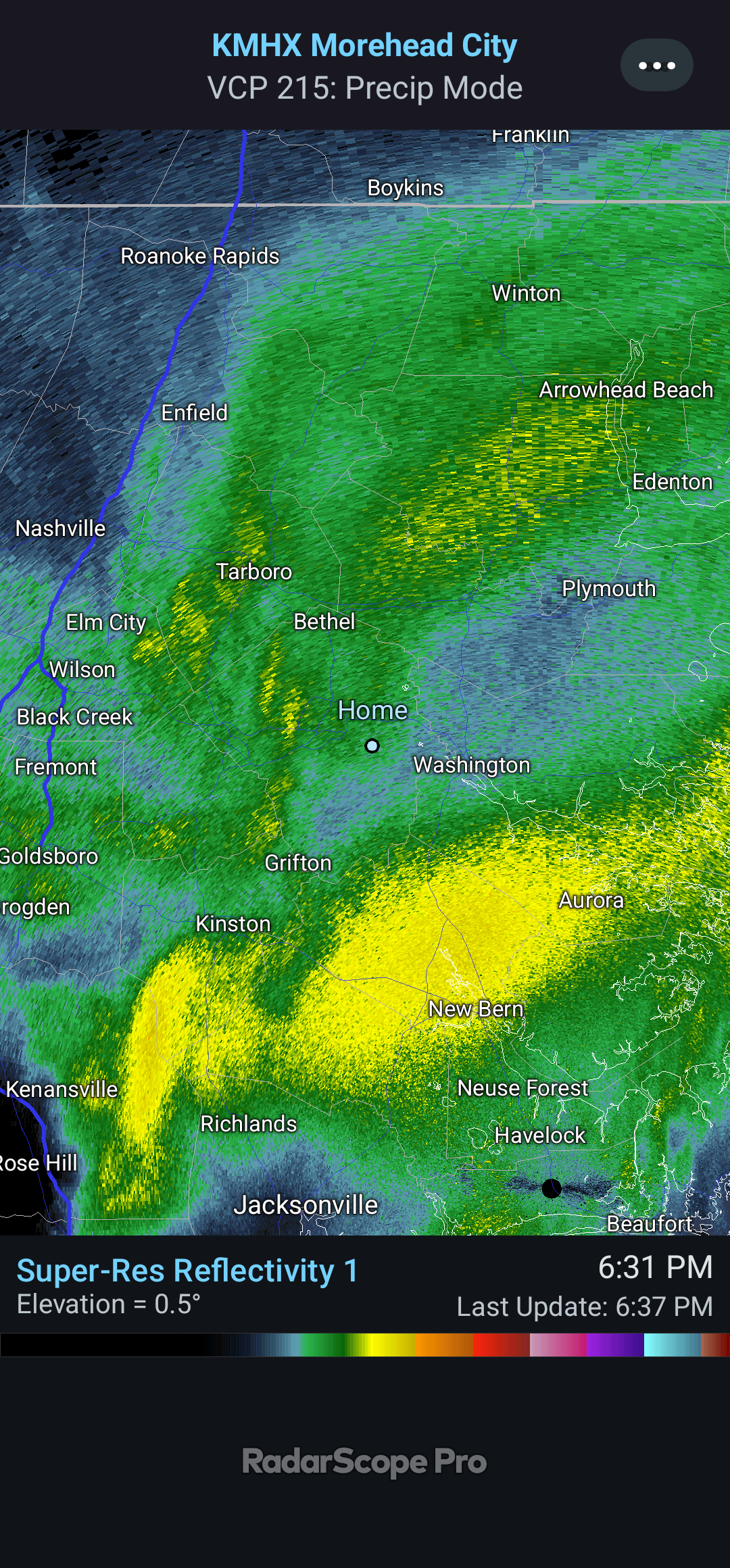
Seeing reports of 20-30" in Pamlico Co down to MHX/Emerald Isle/Swansboro I got anywhere from 13-16" in the flattest areas I could find IMBY -
January 30th- Feb 1st ULL and coastal storm obs
downeastnc replied to JoshM's topic in Southeastern States
Ratios and rates are the best I have ever seen, not often its puking snow in the upper teens in NC, only other time for MBY was probably Mar 1980. -
The “I bring the mojo” Jan 30-Feb 1 potential winter storm
downeastnc replied to lilj4425's topic in Southeastern States
-
The “I bring the mojo” Jan 30-Feb 1 potential winter storm
downeastnc replied to lilj4425's topic in Southeastern States
I hope so for yalls sake it works out, even under no returns its dumping snow you get under and dark greens or yellows and its the hardest snow I have seen in literally decades. -
The “I bring the mojo” Jan 30-Feb 1 potential winter storm
downeastnc replied to lilj4425's topic in Southeastern States
Im about to get dunked on thats one serious band
-
The “I bring the mojo” Jan 30-Feb 1 potential winter storm
downeastnc replied to lilj4425's topic in Southeastern States
6 inches easy they will get another 6 before it over if these upcoming bands are anything like we have seen so far. I think you guys will still get lucky the negative tilt is pushing the western edge of the coastal precip closer and if you get under it your gonna be surprised how fast it piles up ratios are insane. -
January 30th- Feb 1st ULL and coastal storm obs
downeastnc replied to JoshM's topic in Southeastern States
whiteout conditions with easy "2 a hr rates in Pitt Co...hoping this holds up all night. -
The “I bring the mojo” Jan 30-Feb 1 potential winter storm
downeastnc replied to lilj4425's topic in Southeastern States
The hi res models sure look good but at this point its just wait and see, it all depends on where the bands and dry slots set up. Pretty sure with a semi captured low bombing just offshore that more precip rather than less makes the most sense. -
PGV has 90/82 with a HI of 113 at 945 am.....
-
Pitt County had almost 9" in places and widespread 5-8" totals, many roads underwater this morning and even some washed out....most of it fell in 5-6 hrs. Dozens of water rescues last night as roads flooded and trapped people. This has led to widespread flooding across portions of Greene, Pitt, and Martin Counties, with MRMS maximum ARIs of 70-90 years. In other words, there is roughly a 1% chance of an event like this occurring in any given year, making it a notable flash flood event. What`s more notable is that last night`s event was not associated with any tropical system.
-
took 15 mins to get everything completely covered....now its a wait and see game to see how it plays out in the central coastal plains.
-
Hope your right lol....this is the setup I look for to get 6-12" out of....
-
Euro smack job for eastern half of NC....I95 to Hwy 17 with foot.
-
Sounds like they have well over 100 bodies that have not been identified etc and they are only adding to the death toll when they do ID and notify next of kin. A guy on the hunting forum for NC I am on said they think the actual number will be much higher....a lot of people tried to flee in the vehicles and got caught in the flooding and washed away etc and it will be weeks or month before they find all the victims.
-
Makes you wonder how many times this happened and the people did not get out of the way etc....fear the deaths are gonna creep up for day as they get into areas totally cut off right now.
-
After a few days of no power you wont want to go into a grocery store... upside for the SC/NC powerless is at least its not in the 80-90's everyday for the next few days. Folks down in GA/FL will be without power for a week in the humid hot weather.
-
-
This is bad bad bad
-
Confirmed tornado on ground north of Rocky Mount NC...
-
For NC its the F names, Fran, Floyd, Florence.
-
Pretty sure this is unprecedented
-
Well then....
-
Apparently the dam is overtopping and eroding the foundation of the dam....
-
Charlotte already gusting over 50.... 27 05:52 E 25 G 52 3.00 Rain and Breezy BKN016 OVC024 75.9 71.1 85% 76 29.46 998.1 0.05
-
Its also not really moving N or NNW yet either, and every hr it doesnt it gets 30 miles further into areas that were not expecting what they are about to get...if it does not really start to get captured soon it could get really close to Charlotte in 4-5 hrs....