

Eskimo Joe
-
Posts
24,038 -
Joined
-
Last visited
Content Type
Profiles
Blogs
Forums
American Weather
Media Demo
Store
Gallery
Everything posted by Eskimo Joe
-

Jan 31st - 33rd Storm Obs and Disco like it's 1979
Eskimo Joe replied to Bob Chill's topic in Mid Atlantic
Whenever the rates quick up, we flip right to snow and it's quick. When they back off, it's sleet and a mangled occasional flake. -
Jan 31st - 33rd Storm Obs and Disco like it's 1979
Eskimo Joe replied to Bob Chill's topic in Mid Atlantic
26/25 in Reisterstown with big flakes starting to mix in with the sleet again. -
Jan 31st - 33rd Storm Obs and Disco like it's 1979
Eskimo Joe replied to Bob Chill's topic in Mid Atlantic
Significant improvement on all of the NAMS for I-70 north. -
Jan 31st - 33rd Storm Obs and Disco like it's 1979
Eskimo Joe replied to Bob Chill's topic in Mid Atlantic
850 low looks like it's trying to close off around the tidewater of Virginia. -
Jan 31st - 33rd Storm Obs and Disco like it's 1979
Eskimo Joe replied to Bob Chill's topic in Mid Atlantic
Per the SPC mesoanalysis, the 925 low has closed off over the SC/NC border. This should help lock in low level sub freezing air for places that are already below freezing. -
Jan 31st - 33rd Storm Obs and Disco like it's 1979
Eskimo Joe replied to Bob Chill's topic in Mid Atlantic
Yea just noticed that too. Interesting. -
Feb Long Range Discussion (Day 3 and beyond) - MERGED
Eskimo Joe replied to WinterWxLuvr's topic in Mid Atlantic
Hey if we can manager more snow, let's do it. -
Jan 31st - 33rd Storm Obs and Disco like it's 1979
Eskimo Joe replied to Bob Chill's topic in Mid Atlantic
When I went to put the recycling out, I measured 3.8" It's actually a nice moderate snowfall now, but I'm not sure how long this is going to last. If it were to persist through even midnight I'd definitely clear 6". -
Jan 31st - 33rd Storm Obs and Disco like it's 1979
Eskimo Joe replied to Bob Chill's topic in Mid Atlantic
Actually moderate snow in Reisterstown. If this keeps up for a few hours, I might push low end warning criteria. -
Jan 31st - 33rd Storm Obs and Disco like it's 1979
Eskimo Joe replied to Bob Chill's topic in Mid Atlantic
Rates picking back up in Reisterstown. 25/24 -
Jan 31st - 33rd Storm Obs and Disco like it's 1979
Eskimo Joe replied to Bob Chill's topic in Mid Atlantic
Yea, just hit in the chat room after I posted. -
Jan 31st - 33rd Storm Obs and Disco like it's 1979
Eskimo Joe replied to Bob Chill's topic in Mid Atlantic
Updated totals: IAD, 2.7" BWI, 2.3" Still haven't seen anything from DCA. -
Jan 31st - 33rd Storm Obs and Disco like it's 1979
Eskimo Joe replied to Bob Chill's topic in Mid Atlantic
Your temp drop is almost certainly from diurnal swing. The SPC meso analysis has the 925 and 850 temps well below freezing. -
Jan 31st - 33rd Storm Obs and Disco like it's 1979
Eskimo Joe replied to Bob Chill's topic in Mid Atlantic
M3.5" Reisterstown (I'm the report on the PNS). Grass starting to really get covered now. Happy I left my Christmas lights up. Going to turn them on tonight. Just 11 months until Santa time! -
Jan 31st - 33rd Storm Obs and Disco like it's 1979
Eskimo Joe replied to Bob Chill's topic in Mid Atlantic
Man, WBAL always hugs their IBM models. This morning they had 6" - 12" north of I-70. -
Jan 31st - 33rd Storm Obs and Disco like it's 1979
Eskimo Joe replied to Bob Chill's topic in Mid Atlantic
Per the SPC meso analysis, the coastal low looks pretty close to popping. -
Jan 31st - 33rd Storm Obs and Disco like it's 1979
Eskimo Joe replied to Bob Chill's topic in Mid Atlantic
Despite weak radar return in Reisterstown, we have steady SN-. 25/24 -
Jan 31st - 33rd Storm Obs and Disco like it's 1979
Eskimo Joe replied to Bob Chill's topic in Mid Atlantic
Yea, it's actually really encouraging. -
Jan 31st - 33rd Storm Obs and Disco like it's 1979
Eskimo Joe replied to Bob Chill's topic in Mid Atlantic
Both of the 18z NAMS are encouraging for the Maryland side of the Potomac, and especially up through Frederick, Carroll, and Baltimore to the NE. -
Jan 31st - 33rd Storm Obs and Disco like it's 1979
Eskimo Joe replied to Bob Chill's topic in Mid Atlantic
Updated LWX AFD: -
Jan 31st - 33rd Storm Obs and Disco like it's 1979
Eskimo Joe replied to Bob Chill's topic in Mid Atlantic
Posting this for future reference. The latest update from SPC meso analysis page show the nasty dry slot at 700mb. If this low was over Kentucky, just about everyone would be in a better situation.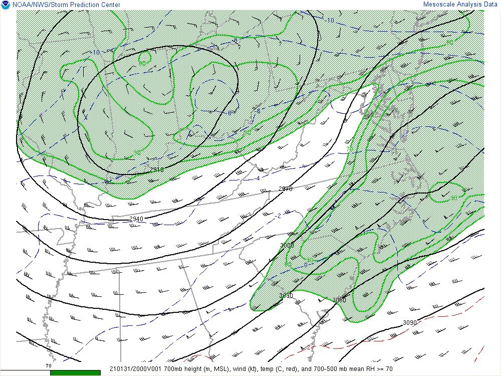
-
Jan 31st - 33rd Storm Obs and Disco like it's 1979
Eskimo Joe replied to Bob Chill's topic in Mid Atlantic
Got a pic? -
Jan 31st - 33rd Storm Obs and Disco like it's 1979
Eskimo Joe replied to Bob Chill's topic in Mid Atlantic
From the warm air advection, probably. But everyone is still hoping on the coastal to deliver some love and it's still possible, especially up here in the Baltimore area. -
Jan 31st - 33rd Storm Obs and Disco like it's 1979
Eskimo Joe replied to Bob Chill's topic in Mid Atlantic
The latest HRRR has the DGZ high and ry through about 7 to 10 pm. After that things become more favorable for steadier precip. in Maryland.


