Eskimo Joe
-
Posts
24,697 -
Joined
-
Last visited
Content Type
Profiles
Blogs
Forums
American Weather
Media Demo
Store
Gallery
Everything posted by Eskimo Joe
-
-
-
I'd be happy with climo snowfall and like -2 temps for Jan and Feb.
-
-
Expansion of urban areas, IMO, is a sizeable contributor to AGW. More concrete, more car exhaust for VOCs, less green space.
-
Ian on Twitter likes the Jan 5th to 20th time frame for something decent.
-
@brooklynwx99 thank you for the analysis.
-
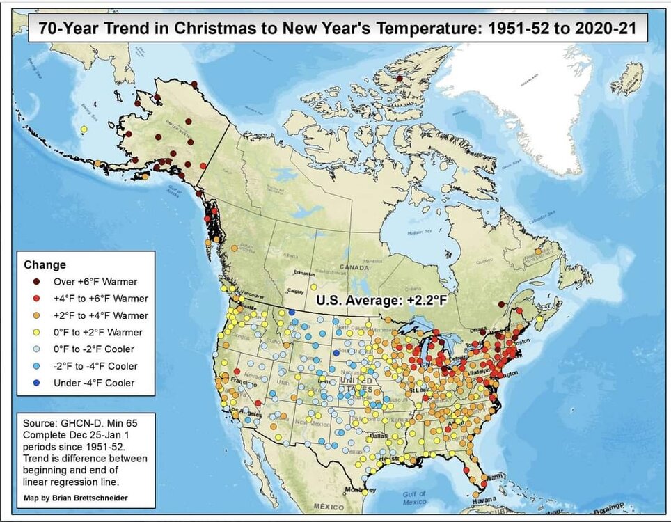
No caption needed.
-
Same.
-
I believe it. We're starting to get more wildland fires during the afternoons. Loch Raven reservoir had one that was something over like 6 acres the other day.
-
New updates to the Tempest Android app are nice. Now shows highest/lowest temp, wind, rainfall, etc. recorded in the past month, year, and all time. Considering the constraints I have on the size of my property, this is a nice little weather station.
-
 Millersville is a great school. Great staff, Dr. DeCaria especially.
 -
That's the one. My age is starting to show.
-
Totally understand. Based off other posters here and Twitter (HM, Eric Webb), the PNA appears to be heading to a less than hostile set up past Jan 1 - 4 timeframe. If this kept getting kicked back to the point where it would be showing this transition past Jan 10 - 15. I'm not saying this is going to be Winter 2009 - 2010, but you can see on the GFS and the Canadian how the gulf opens up a bit and storms aren't ejecting out of Denver into the Great Lakes. We are at least standing a shot at some frozen.
-
My apologies. I mean to say 2018 - 2019 and I've gone back and corrected my post.
-
Really happy to see the pattern isn't getting stuck in D15 or beyond. Folks shouldn't focus on a single piece of energy or one potential event waffling north or south, etc. We're in a far better position than this time in 2018, where it was pretty clear the rest of the winter was going to be a dud. EDIT: Got the years mixed up, corrected for winter of 2019 - 2020.
-
For those of you who miss the days when TWC played Christmas music on the Local on the 8s: https://twcclassics.com/search.php?query=christmas§ion=audio
-
Temps spiking. I have a neighborhood cherry tree and forsythia bush blooming.
-
That was the best winter of my life. The only thing that would've made it better is if the December snow lasted for Christmas.
-
I have drizzle and a few pingers. 34/22
-
Yikes. Credit to Chuck, he called this.
-
CrankyWxGuy.
-
Those are great events because you and build up a thick, dense sleepy snowpack.