

Itstrainingtime
-
Posts
19,629 -
Joined
-
Last visited
Content Type
Profiles
Blogs
Forums
American Weather
Media Demo
Store
Gallery
Posts posted by Itstrainingtime
-
-
1 minute ago, Bubbler86 said:
Ground truth on this may bring a teary haze to some eyes.

Very true.
I wasn't really invested in today that much mostly because the positive snow depth maps were all hideous. Just another reason why someone doesn't like those snow maps...they don't tell the whole story. Or at least an accurate one. That's all I will say as I do NOT want to lecture or act like a know it all - I certainly don't. But I do know not to trust snow maps.
On to Saturday.
")
-
 4
4
-
-
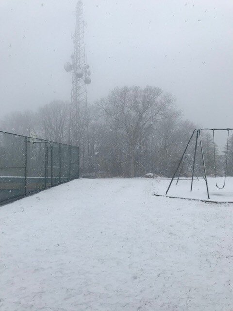
59 minutes ago, Mount Joy Snowman said:
Can report back that, sure enough, there is at least a solid inch on the ground on top of Chickies at ~700', whereas I only have a trace down here in the lowlands. Snowing a little harder with a lower temp as well, as expected. The top of the cell tower was very obscured. Nothing on the basketball court but believe it or not the little side road leading up to the park was caving, enough that I even slid a little coming down it ha. Well, that is my most exhilarating and likely final winter moment for this season. It's a sad life I lead.

Good stuff, and thank you so much! Here on top of Turkey Hill, we had only the slightest of coatings...more like a white haze actually. Plain rain even here now.
-
4 minutes ago, Mount Joy Snowman said:
Good stuff. Yeah I'm going to drive to the little park less than a mile to the south of me in about an hour to see if anything has stuck up there. It's one of the higher spots along Chickies Ridge, sitting at ~700'.
Please report back on your findings. This is serous biz.
-
5 minutes ago, Mount Joy Snowman said:
Sitting at 36 here and despite a good 20 minutes now of heavy wet snow nothing is able to stick to any surfaces. Wet ground and warm temps just won't allow for it around here. As @Itstrainingtime mentioned, Lancaster County really is the battleground with varying conditions all around the county. But bottom line is minimal to no accumulation will be the result. Heck, not even my north facing mulch bed is taking it on.
Drover over Chickies about 45 minutes ago - snowing very hard on top of the hill with zero rain mixed near the summit, but nothing visible on the ground even at the top. (again, slightly dated info :))
-
1 minute ago, Bubbler86 said:
About one half inch on the ground just a half mile up the mountain from me. Blue Ridge has snow on side roads.
Couple of inches this morning possible at Whitetail?
-
1
-
-
23 minutes ago, Bubbler86 said:
Surely not perfect but a decent depiction of the variability of the reports this AM.

Just saw this map - I can tell you with certainty that in Lanco, based on my driving this morning, that is pretty much spot on! Higher hills of southern Lanco (including work) are getting some wet snow, and also the higher elevations of northern Lanco, but a lot of rain elsewhere.
-
Maytown: 36.3 with a 80/20 rain/snow mix according to Mrs. Training
Work: 35.4 with a 50/50 mix
MU: they're currently reporting 40 and I'd assume all rain
-
All rain here in Maytown.
-
-
Elliott steadfast on a coating to 1" outside of higher elevations.
-
5 minutes ago, Bubbler86 said:
GFS holding stout with Snow TV tomorrow and Saturday. The cold plunge coming Saturday night means business. Also, lows in the mid 20's Thursday AM this week (LSV).
Edit, Sat is actually more than Snow TV. Its an all all snow storm for Eastern PA.
Saturday looks far more intriguing to me than tomorrow ever has. (and by that, I'm talking upside potential...we could easily see a minor, slushy accumulation tomorrow and nothing on Saturday, but Saturday's potential seems to merit some interest.)
-
2
-
-
11 minutes ago, pasnownut said:
Flying back from FL was a bit fun yesterday afternoon. Wasnt too bad, but last hour was rather roller coaster ish. Glad we werent coming back last night.
Looks like we have a chance at some slushy accums tomorrow. Looks like a blue mtn north special incoming. Hope y'all enjoy your slushy couple inches (for those that get it). Car topper is my bar down here.
Were you flying into PHL, BWI, or MDT? Regardless, glad you got home safely.
8 minutes ago, Bubbler86 said:LOL. You do not want to see it coming to swerve and miss the wheels?
With temps between 32 and 35, I doubt there will be much plowing. LOL.
I literally was terrified of getting flipped over to worry about other things hitting me.
I just checked PHL's observations for last evening - at 9:40pm (time we were on the bridge) the obs show wind gusts of 58mph. I imagine they were higher on top of the bridge?
-
 1
1
-
-
6 minutes ago, Mount Joy Snowman said:
.08" of rain yesterday with a low of 37, currently at 39. Looks like LNS recorded a 59mph gust with the frontal passage.
As for tomorrow morning's snow chances down this way, I'm growing more pessimistic by the hour. Temperature issues abound. The lower levels of the column aren't all that cold and the surface temps are downright problematic. As I said yesterday, dew points at or above freezing don't exactly scream efficient accumulation haha. This is to say nothing of daytime solar effects and lighter intensity periods. Ratios will likely be abysmal. MAG went over most of this yesterday, but for us in the southern reaches of the LSV the issues are mounting. Elevation will be key and I ain't got it. Going with an O/U of 1" for my back yard. As always, I hope to be wrong. Good luck to all but keep expectations in check. Toodles.
Yes sir. In complete agreement. I honestly expect very little to show itself as ground truth.
-
3 minutes ago, Bubbler86 said:
Yea, hate to be on a bridge when planes are doing anything nearby.
If you're familiar - planes approach PHL from the north and are right beside I95. From the top of the bridge you have a clear shot at watching them land. We always enjoy the added "perk" especially at night time but I wasn't looking anywhere but in front of me last night.
Most of the positive snow depth maps I'm seeing for tomorrow are really uninspiring - are the snow maps greatly exaggerating how much will actually accumulate? I guess we'll find out soon enough.
-
In 40+ years of driving, never have I experienced the effect of wind on a car like I did last night on the Girard Point Bridge leaving the 76ers game. The crosswinds were insane - despite the fact that there was little traffic on the bridge, I don't think anyone was going more than 45mph. Everyone was holding on to their steering wheels for dear life.
-
22 minutes ago, paweather said:
CTP only calling for 1-2" that is low.
Given all of the concerns that have been mentioned, that doesn't seem low to me. This has coating to perhaps a slushy couple of inches written all over it outside of higher elevations.
As usual, I could be very wrong.
34 minutes ago, Bubbler86 said:Veritable jungle over there in the historic area!
I was pretty happy to get back to the historic area late last night. I left the Wells Fargo Center and was greeted by flying debris everywhere. It was insane. I knew that when we got on the bridge crossing the Schuylkill River that we were in for a wild ride. It delivered. My wife said that a plane aborted landing while we were on the bridge - I was too scared to look, LOL
-
1
-
-
12 minutes ago, Bubbler86 said:
32 in Rou this AM
A balmy 39 here.
-
MU update for Wednesday:
In the wake of the front, clearing skies will accompany temperatures that'll drop into the 30s by daybreak. A high pressure system settling over the Commonwealth on Tuesday will cause winds to become light later in the afternoon, but it will feel much chillier outside with highs only reaching the mid-40s to around 50. It's no secret that the "word is out" with regard to a late-season snow threat on Wednesday, with the weather slated to do a "total 180" in a matter of just 36 hours or less. A disturbance currently located over the Four Corners region will move rapidly northeastward into the central US on Tuesday and "stay the course" as it pushes into western PA by Wednesday. To the southeast of the disturbance, a storm system will develop across the Tennessee River Valley and move to a position off the Delmarva Peninsula by Wednesday. The air mass settling overhead Tuesday night should be "just cold enough" for a period of snow to occur across southern PA and far northern Maryland on Wednesday morning. Of course, it will only take a subtle shift north in the storm's track, or the chilly air mass to not push quite as far south, for snow to be mixed with or just end up being plain rain Wednesday morning. At this time, I actually do favor (with about 60/40 odds) a period of all snow Wednesday morning since the storm should track well to our south. I expect snow to overspread the Lower Susquehanna Valley from southwest-to-northeast around daybreak or in the pre-dawn hours Wednesday and continue throughout much of the morning. Despite the fact that it may snow for 4-6 hours, there are still plenty of reasons to be skeptical of anything more than a "nuisance" event.
First, low temperatures Tuesday night will only fall into the low-to-mid 30s and remain above freezing while it's snowing Wednesday morning. Secondly, ground, roadway, and sub-surface temperatures are way above freezing following the record-breaking warmth and will stay that way through the rest of the week. Finally, the snow will be occuring primarily during the daylight hours and have to battle the strong March sun, whose angle is now equivalent to that of early October. Under these circumstances, it will have to snow at the rate of 1-2" per hour for snow to stick on paved surfaces. It may even be challenging for the snow to stick on non-paved surfaces, especially in the valleys and lower elevations. A few hundred feet of elevation can make a 1-2 degree difference in temperature, and this is often vital when talking about snowfall accumulations in March. So, I suspect that most locations will pick up a general coating to one inch of snow, with 1-3" more likely along the South Mountain Range and higher elevations in northern Lancaster County. Higher elevations to the north/west of Harrisburg also have a greater chance of receiving 1-3" of snow. If the snow arrives a few hours earlier than anticipated, then there's a higher probability of greater snowfall amounts since more would fall before sunrise. Keep in mind that these accumulations are with respect to grassy surfaces. I expect paved surfaces to generally remain wet, with any slushy spots being confined to untreated, secondary roadways in the highest elevations. The primary weather-related travel issue will be reduced visibility in any heavier bands of snow during the Wednesday morning commute. Be sure to reduce speed if you encounter areas of low visibility, and exercise caution on the wet roadways. As temperatures slowly climb into the upper 30s and precipitation lightens around midday, snow will mix with and change to rain before ending late Wednesday afternoon.
-
Probably experienced one of the more intense moments in 40+ years of driving leaving south Philly tonight - the winds on top of the Girard Point Bridge leaving the stadium complex was unreal. I was holding on to the steering wheel for dear life as the cross winds at the top of the span were pushing the car all over the place. No idea how high the winds were but I've driven through many a storm over the years and have never been pushed around like that.
-
Stuck at 74 here for the past hour plus.
-
2 minutes ago, paweather said:
Why not. I need to use it. It has been locked up all winter long.
Well then. Shoot that white gold SW of you to Maytown.
-
4 minutes ago, paweather said:
It is time to get the blower out in Myra.
You're going to blow the snow off your grass?
-
 1
1
-
-
10 minutes ago, Superstorm said:
Even GFS shows snow now.
.7 minutes ago, Bubbler86 said:I think they will be changing this evening. GFS is a paste snow as well.
It'll be interesting to read Kyle's thoughts later today...
-
1
-
-
16 minutes ago, paweather said:
I'm not sure what CTP is thinking with their Wednesday forecast the NAM disagrees with it
Probably thinking that the NAM is wrong?
Actually - CTP's forecast for Wednesday was out long before the 12z NAM.

Central PA - Winter 2021/2022
in Upstate New York/Pennsylvania
Posted
They bring a false sense of joy to some only to be replaced with sorrow and disappointment 90% of the time.")