HillsdaleMIWeather
-
Posts
3,836 -
Joined
-
Last visited
Content Type
Profiles
Blogs
Forums
American Weather
Media Demo
Store
Gallery
Everything posted by HillsdaleMIWeather
-
IWX just issued there first Blowing Dust Advisory ever
-
 GRR has confirmed multiple long track albeit weak tornadoes
 -
IWX is claiming on Facebook they included Hillsdale in the watch but didn't Looks like someone made an oopsie
-
lol good job iwx

-
Some new cells are going up just south of South Bend, might be interesting if they can stay ahead of the line
-
Looks like me and @Harry Perrymight end up getting nothing
-
Might end up getting nothing from the CAP here
-
That new tornado watch not including Branch Hillsdale or any of DTX is a... choice
-
all it's gonna take is one supercell popping ahead of the line for southern MI or Northern Indiana to get smoked in this environment
-
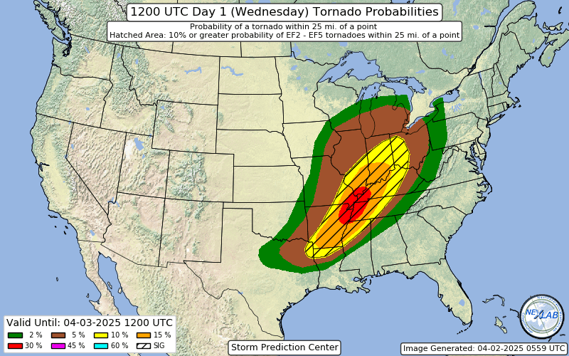
Enhanced risk expanded slightly south and further east to Detroit, 30% sig wind introduced over Northern Indiana and Southern Michigan. They're expecting mature supercell's ahead of the line so some areas could have a tornado threat and then damaging wind right behind it
-
The little bit of fog this morning has a forboding feeling here
-
That supercell takes basically the same track as the Palm Sunday F4s, eerie.

-
Large Enhanced now, but with the caveat of the event either being boom or bust
-
Fall/Winter '24 Banter and Complaints Go Here
HillsdaleMIWeather replied to IWXwx's topic in Lakes/Ohio Valley
The fact yesterday ended up not having much severe in most of the slight risk (except for that hail that survived from the day befores storms out west) makes me think that the SPC really needs to stop doing these giant day 4-8 slight risks for marginal events. -
Yep, got 2 inches OTG
-
Absolutely puking snow here rn
-
4/2-4/3 Potential Major Severe WX Outbreak
HillsdaleMIWeather replied to Geoboy645's topic in Lakes/Ohio Valley
IWX also confirmed two fairly long trackers that went from Stueben County into Branch County MI. If warm front had gotten further north there'd have been way more tornadoes. -
4/2-4/3 Potential Major Severe WX Outbreak
HillsdaleMIWeather replied to Geoboy645's topic in Lakes/Ohio Valley
With a slightly more unstable environment yesterday could have been even worse, we dodged a big bullet locally -
4/2-4/3 Potential Major Severe WX Outbreak
HillsdaleMIWeather replied to Geoboy645's topic in Lakes/Ohio Valley
Surprise high risk for down south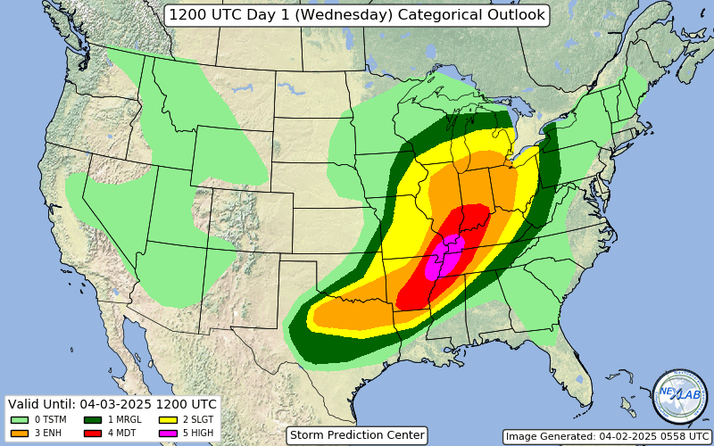
-
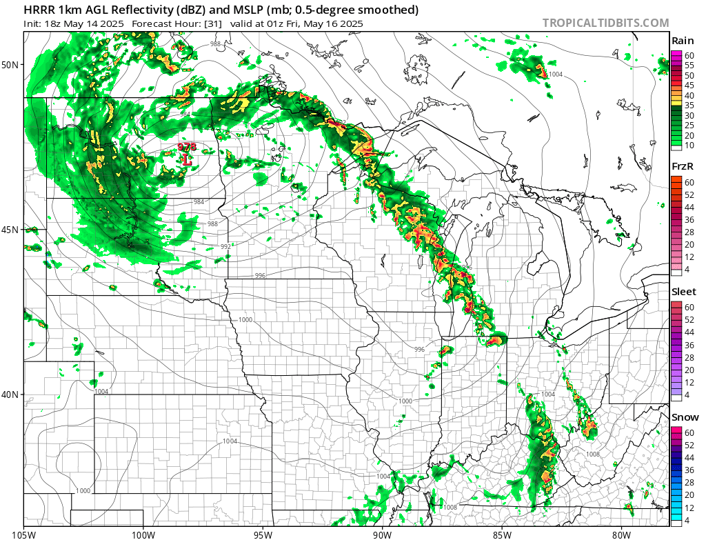
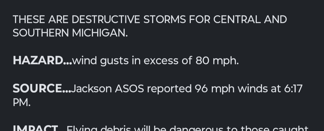
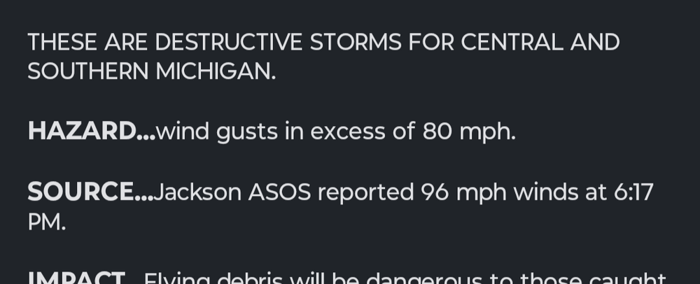
Went about 14 hours without power, storm knocked out the main transmission line to Branch and Hillsdale counties.
-
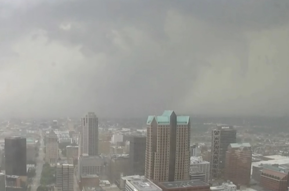
Jackson county says "bet'
-
Have a tornado warned storm moving my way and they haven't even done a local watch extension. Makes no sense.
-
Weird watch gap for NW Ohio/SE Michigan rn, you'd think they'd wanna hurry and issue one considering the storms are like less than an hour out
-
Enhanced expanded again