MazooWeather
-
Posts
3,866 -
Joined
-
Last visited
Content Type
Profiles
Blogs
Forums
American Weather
Media Demo
Store
Gallery
Everything posted by MazooWeather
-

1/24-1/25 Major Winter Storm - S. IL, IN, and OH
MazooWeather replied to A-L-E-K's topic in Lakes/Ohio Valley
GFS is north but still well south of the other models -
Winter 2025-26 Medium/Long Range Discussion
MazooWeather replied to michsnowfreak's topic in Lakes/Ohio Valley
18Z gfs would shut down the southeast for days Insane run -
Winter 2025-26 Short Range Discussion
MazooWeather replied to SchaumburgStormer's topic in Lakes/Ohio Valley
Backroads here are completely drifted shut from the wind today. Real Alaska type vibes out rn. -
Winter 2025-26 Short Range Discussion
MazooWeather replied to SchaumburgStormer's topic in Lakes/Ohio Valley
Lol I love the random iwx headline holes
-
Winter 2025-26 Short Range Discussion
MazooWeather replied to SchaumburgStormer's topic in Lakes/Ohio Valley
Ended up around 5 inches here in Hillsdale. From not even expecting a dusting to completely covered. -
Winter 2025-26 Short Range Discussion
MazooWeather replied to SchaumburgStormer's topic in Lakes/Ohio Valley

-
My mom who helped encourage my love of meteorology and all things weather related passed away on New years day unexpectedly. Tracking events is gonna feel a little bit emptier without being able to excitedly inform her about snowstorms or severe weather risks.
-
If you could re-experience ONE winter event....
MazooWeather replied to cyclone77's topic in Lakes/Ohio Valley
Following the rules; GHD 2011. I remember the hype of it and just the absolutely incredible blizzard conditions and thundersnow overnight. Storm I never wanna repeat was the ice storm a few weeks later which hit Hillsdale, Lenawee And Monroe counties particularly hard since we were on the line between snow and rain and got all freezing rain, over an inch and a half with 35 mph winds . Some people didn't get power back for almost two months and schools were closed for 10 days. Cheating if I could see a storm that was in my mom's lifetime would be the 1978 blizzard, Hillsdales snow plows all got stuck so the only way people in the medical field like her could travel was via snowmobile and most employees ended up living at the nursing home she worked at for over a week until the national guard cleared the roads. -
Upper peninsula is gonna get utterly rocked tonight
-
Winter 2025-26 Medium/Long Range Discussion
MazooWeather replied to michsnowfreak's topic in Lakes/Ohio Valley
-
Winter 2025-26 Medium/Long Range Discussion
MazooWeather replied to michsnowfreak's topic in Lakes/Ohio Valley
Euro also has pretty widespread freezing rain up to the border, definitely something to watch -
Winter 2025-26 Medium/Long Range Discussion
MazooWeather replied to michsnowfreak's topic in Lakes/Ohio Valley
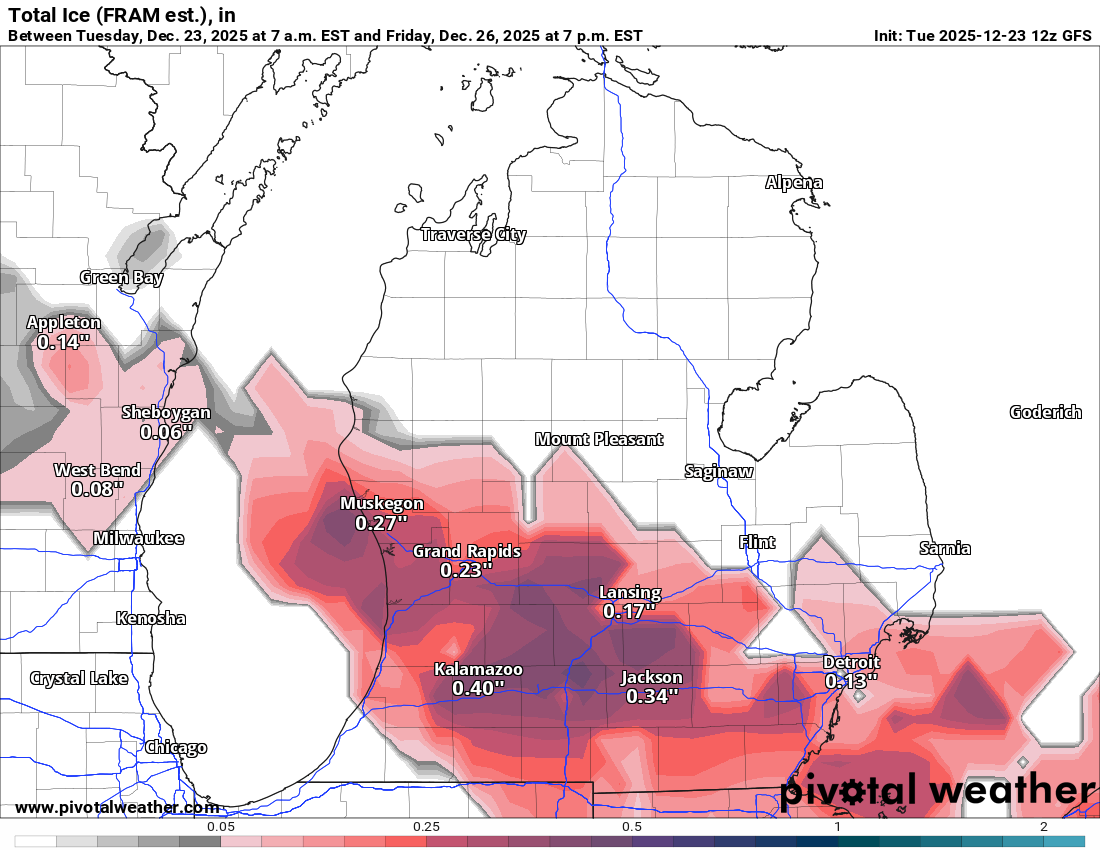
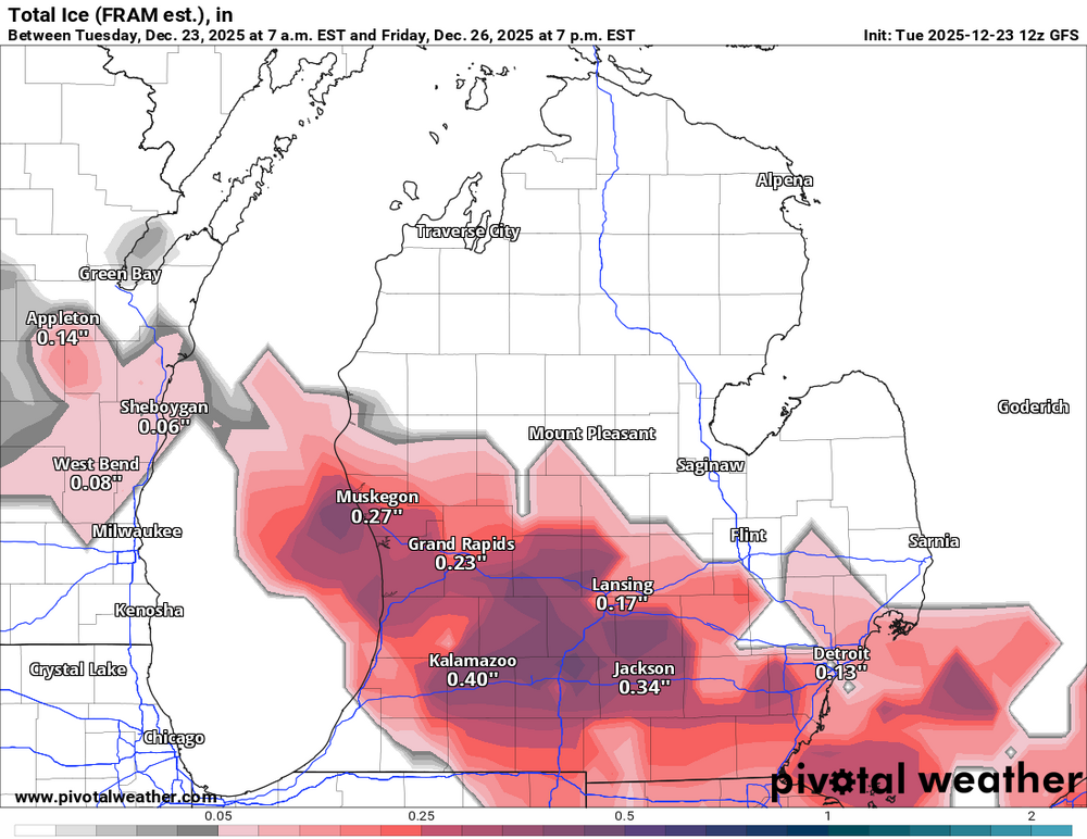
0Z GFS is wanting to utterly nuke Grand Rapids to Detroit with an ice storm the day after Christmas -
IWX just issued their first Snow Squall Warning ever
-
Oh my god the warning text only calls for an inch of snow, that's embarrassing. If it's for the blowing snow and flash freeze they should've just done a WWA.
-
Dec 6-7th (It's not a clipper) Clipper
MazooWeather replied to Chicago Storm's topic in Lakes/Ohio Valley
Looks like we're gonna end up closer to 2 to 4 than 1 to 2 here. -
Kiddos here got another snow day thanks to this, the still not amazing backroads got completely wrecked again
-
Winter 2025-26 Medium/Long Range Discussion
MazooWeather replied to michsnowfreak's topic in Lakes/Ohio Valley
Euro also has the system for next weekend now, if the storm today, the duster Monday night and this new storm come to pass we could all have one hell of a snowpack -
Nov 28-30th Post Turkey Day Winter Storm
MazooWeather replied to Chicago Storm's topic in Lakes/Ohio Valley
Final total here is 9 inches. Very memorable storm, thankfully with less blowing and drifting than our last big November storm -
Nov 28-30th Post Turkey Day Winter Storm
MazooWeather replied to Chicago Storm's topic in Lakes/Ohio Valley
Last little burst coming through here, what a lovely storm. -
Nov 28-30th Post Turkey Day Winter Storm
MazooWeather replied to Chicago Storm's topic in Lakes/Ohio Valley
Starting to come down heavy here in Hillsdale, grass is finally covered nicely -
Nov 28-30th Post Turkey Day Winter Storm
MazooWeather replied to Chicago Storm's topic in Lakes/Ohio Valley
Excited to see the weenie band by fort wayne get here -
Winter 2025-26 Medium/Long Range Discussion
MazooWeather replied to michsnowfreak's topic in Lakes/Ohio Valley
Gfs has ANOTHER storm next weekend lol -
Nov 28-30th Post Turkey Day Winter Storm
MazooWeather replied to Chicago Storm's topic in Lakes/Ohio Valley
Iwx just upped the amounts to 9 to 14, must be something juicy in the 18Z suite -
Nov 28-30th Post Turkey Day Winter Storm
MazooWeather replied to Chicago Storm's topic in Lakes/Ohio Valley
DTX is gonna have to go from no headlines to warnings at this point -
Nov 28-30th Post Turkey Day Winter Storm
MazooWeather replied to Chicago Storm's topic in Lakes/Ohio Valley
Real Weenie Time