HillsdaleMIWeather
-
Posts
3,838 -
Joined
-
Last visited
Content Type
Profiles
Blogs
Forums
American Weather
Media Demo
Store
Gallery
Everything posted by HillsdaleMIWeather
-

March 10th, 2026 Severe Threat
HillsdaleMIWeather replied to pen_artist's topic in Lakes/Ohio Valley
Nasty cc drop over lake village -
March 10th, 2026 Severe Threat
HillsdaleMIWeather replied to pen_artist's topic in Lakes/Ohio Valley
Kinda interesting how areas further east in IN/MI/OH might have a higher tornado chance than expected later because of where the front is -
March 10th, 2026 Severe Threat
HillsdaleMIWeather replied to pen_artist's topic in Lakes/Ohio Valley
Not much forming yet on the west end back in Iowa yet it seems -
March 10th, 2026 Severe Threat
HillsdaleMIWeather replied to pen_artist's topic in Lakes/Ohio Valley
70/60 probs for TORs -
March 10th, 2026 Severe Threat
HillsdaleMIWeather replied to pen_artist's topic in Lakes/Ohio Valley
Would expect the watch any minute now -
March 10th, 2026 Severe Threat
HillsdaleMIWeather replied to pen_artist's topic in Lakes/Ohio Valley
SUMMARY...AN UPGRADE TO A TORNADO-DRIVEN MODERATE RISK WILL BE ISSUED WITH THE MIDDAY DAY 1 CONVECTIVE OUTLOOK. DISCUSSION...PLEASE SEE THE FORTHCOMING 1630Z DAY 1 CONVECTIVE OUTLOOK FOR FURTHER DETAILS. -
2026 Severe Wx - General Thread
HillsdaleMIWeather replied to largetornado's topic in Lakes/Ohio Valley
Union City got raised to 160, sounds like they're debating increasing it more in the future as one of the houses had good anchor bolts -
2026 Severe Wx - General Thread
HillsdaleMIWeather replied to largetornado's topic in Lakes/Ohio Valley
Round two for basically the whole area Tuesday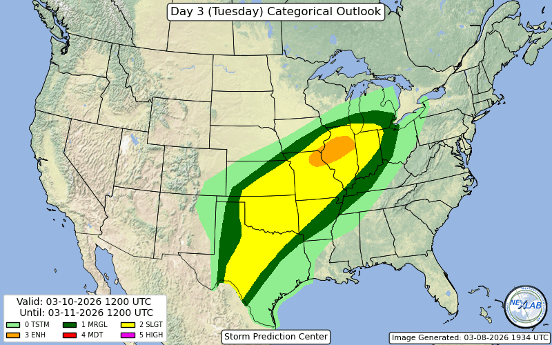
-
2026 Severe Wx - General Thread
HillsdaleMIWeather replied to largetornado's topic in Lakes/Ohio Valley
-
2026 Severe Wx - General Thread
HillsdaleMIWeather replied to largetornado's topic in Lakes/Ohio Valley
165 now, might be upgraded to EF4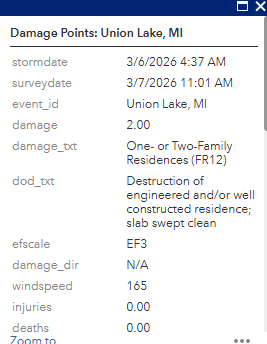
-
2026 Severe Wx - General Thread
HillsdaleMIWeather replied to largetornado's topic in Lakes/Ohio Valley
Just got a preliminary EF3 rating for Union City, and that's with the caveat that the nws could only access a small area of damage today due to most areas still being impassable. -
2026 Severe Wx - General Thread
HillsdaleMIWeather replied to largetornado's topic in Lakes/Ohio Valley
MSC has a video of it crossing Union Lake https://www.facebook.com/reel/909342021952544/ -
2026 Severe Wx - General Thread
HillsdaleMIWeather replied to largetornado's topic in Lakes/Ohio Valley
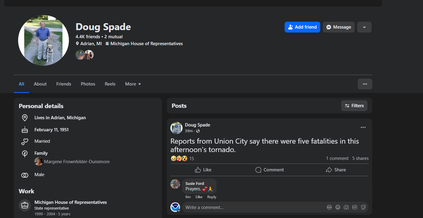
Former state rep for the area posted it but it was also on the scanner a little bit ago.
-
2026 Severe Wx - General Thread
HillsdaleMIWeather replied to largetornado's topic in Lakes/Ohio Valley
Branch County reporting 5 fatalities with more missing still -
2026 Severe Wx - General Thread
HillsdaleMIWeather replied to largetornado's topic in Lakes/Ohio Valley
Multiple fatalities in Union City
-
2026 Severe Wx - General Thread
HillsdaleMIWeather replied to largetornado's topic in Lakes/Ohio Valley
Not one to crap on the spc but kinda baffled they didn't issue a watch. They've shown multiple times they're willing to issue one for lone supercells causing tornadoes but this time just didn't. -
2026 Severe Wx - General Thread
HillsdaleMIWeather replied to largetornado's topic in Lakes/Ohio Valley
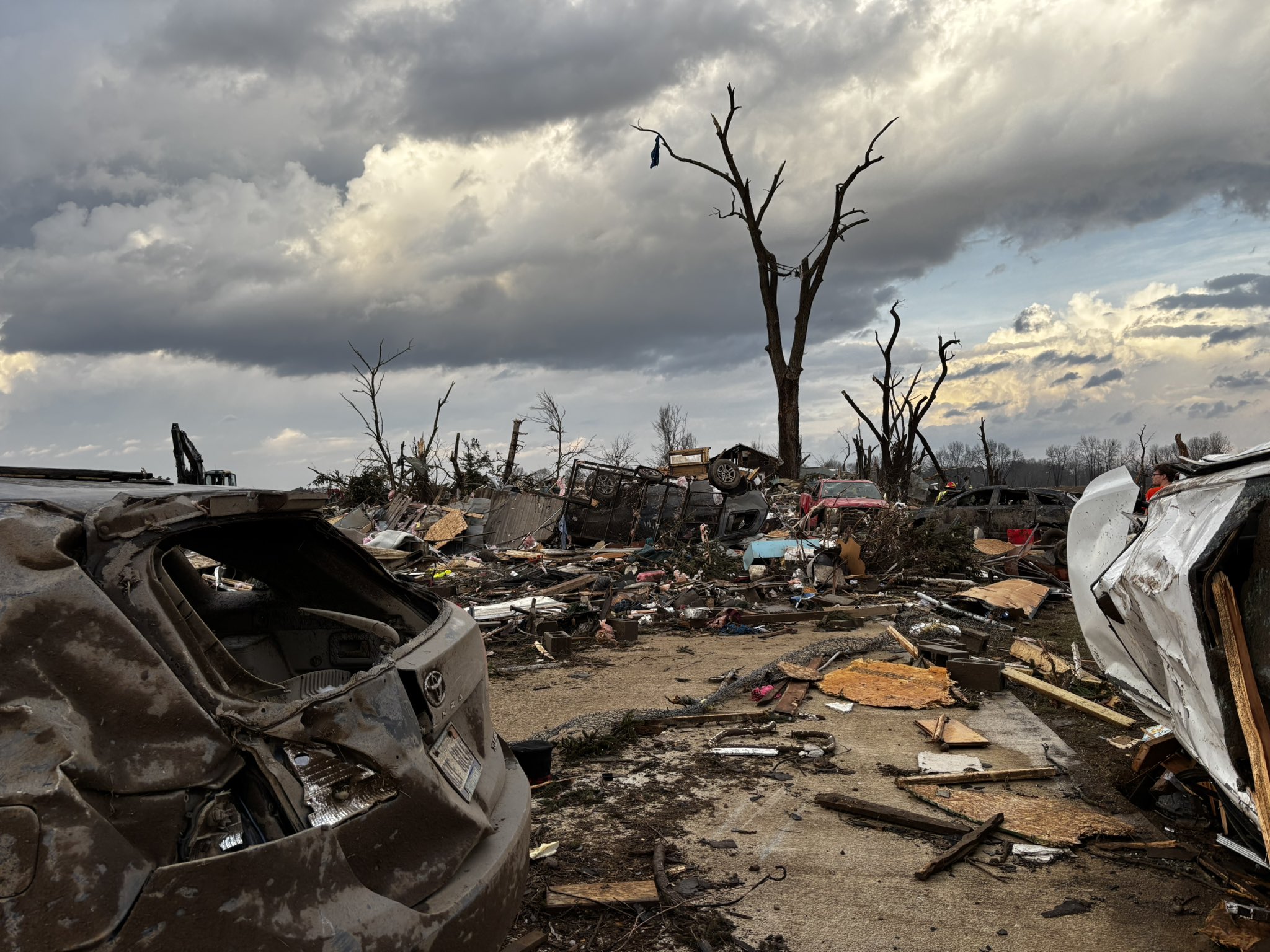
Union City in Branch County just got hit hard, this lone supercell is a prolific tornado maker. -
2026 Severe Wx - General Thread
HillsdaleMIWeather replied to largetornado's topic in Lakes/Ohio Valley
It's bad in three rivers, multiple businesses downtown are completely destroyed -
2026 Severe Wx - General Thread
HillsdaleMIWeather replied to largetornado's topic in Lakes/Ohio Valley
Already seeing a ton of people confused as hell as to what 2% and 5% sig tor risks on the new style maps mean -
2026 Severe Wx - General Thread
HillsdaleMIWeather replied to largetornado's topic in Lakes/Ohio Valley
its time -
0Z GFS lost the storm lol
-
2026 Severe Wx - General Thread
HillsdaleMIWeather replied to largetornado's topic in Lakes/Ohio Valley
n Not every year you this in Indiana at 4:00 AM in the middle of February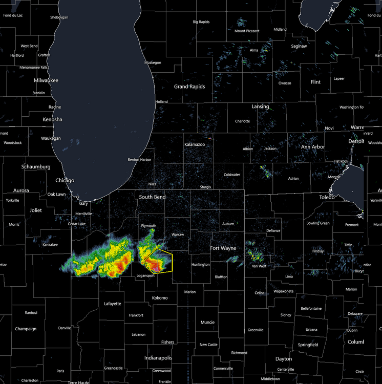
-
Winter 2025-26 Short Range Discussion
HillsdaleMIWeather replied to SchaumburgStormer's topic in Lakes/Ohio Valley
Overnight snow overperformed hard here, finished around 5.5 inches -
1/24-1/25 Major Winter Storm - S. IL, IN, and OH
HillsdaleMIWeather replied to A-L-E-K's topic in Lakes/Ohio Valley
Everyone who's a young person in MI has heard their parents stories about the Blizzard of 78 and therefore craves an epic big dog like that at least once in our lives. -
1/24-1/25 Major Winter Storm - S. IL, IN, and OH
HillsdaleMIWeather replied to A-L-E-K's topic in Lakes/Ohio Valley
Schools here have officially hit 6 school days off in a row, might for 7 or 8 of even more depending on the cold.