HillsdaleMIWeather
-
Posts
3,836 -
Joined
-
Last visited
Content Type
Profiles
Blogs
Forums
American Weather
Media Demo
Store
Gallery
Everything posted by HillsdaleMIWeather
-

Winter 2023/24 Medium/Long Range Discussion
HillsdaleMIWeather replied to Chicago Storm's topic in Lakes/Ohio Valley
Thankfully no matter what this storm will have more wiggle room with a colder air mass to work with -
Winter '23-'24 Piss and Moan/Banter Thread
HillsdaleMIWeather replied to IWXwx's topic in Lakes/Ohio Valley
Has anyone noticed the last couple days the GFS has been a little slower to initialize than normal? -
Winter 2023/24 Medium/Long Range Discussion
HillsdaleMIWeather replied to Chicago Storm's topic in Lakes/Ohio Valley
12Z GEM takes the low through Chicago with a nice spread the wealth scenario for everyone -
Winter 2023/24 Medium/Long Range Discussion
HillsdaleMIWeather replied to Chicago Storm's topic in Lakes/Ohio Valley
Holy crap that second storm is a monster on the 0Z GFS -
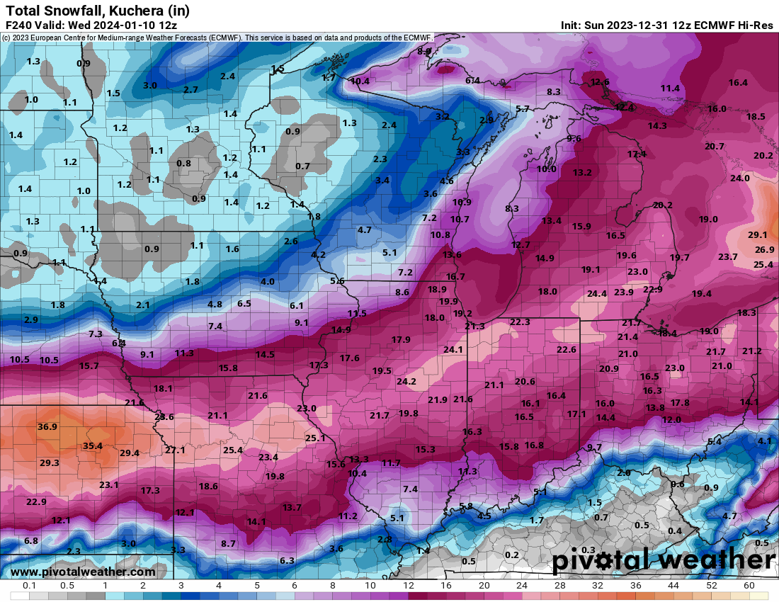
1/8-1/10 Potential Winter Storm
HillsdaleMIWeather replied to Thundersnow12's topic in Lakes/Ohio Valley
Coming in just a tad east so far with the low but the snow area is about the same -
Winter 2023/24 Medium/Long Range Discussion
HillsdaleMIWeather replied to Chicago Storm's topic in Lakes/Ohio Valley
That second storm on the GFS Saturday is basically this one but with more cold air lmao -
1/8-1/10 Potential Winter Storm
HillsdaleMIWeather replied to Thundersnow12's topic in Lakes/Ohio Valley
Chicago folks reeling this one in unless stuff suddenly changes tomorrow or Sunday -
1/8-1/10 Potential Winter Storm
HillsdaleMIWeather replied to Thundersnow12's topic in Lakes/Ohio Valley
Crushes Detroit but yeah that Western cut off is brutal Probably will shift back and forth, we're still far out -
1/8-1/10 Potential Winter Storm
HillsdaleMIWeather replied to Thundersnow12's topic in Lakes/Ohio Valley
-
1/8-1/10 Potential Winter Storm
HillsdaleMIWeather replied to Thundersnow12's topic in Lakes/Ohio Valley
If you all thought the GFS was a weenie run... -
Winter 2023/24 Medium/Long Range Discussion
HillsdaleMIWeather replied to Chicago Storm's topic in Lakes/Ohio Valley
0Z GFS continues to look juicy -
Winter 2023/24 Medium/Long Range Discussion
HillsdaleMIWeather replied to Chicago Storm's topic in Lakes/Ohio Valley
What you mean rating a snowfall map weenie within an hour on your first day being here isn't normal behavior? -
Winter 2023/24 Medium/Long Range Discussion
HillsdaleMIWeather replied to Chicago Storm's topic in Lakes/Ohio Valley
Presented without comment for the committee.
-
December 2023 General Discussion
HillsdaleMIWeather replied to michsnowfreak's topic in Lakes/Ohio Valley
Areas of North Dakota reporting one inch of ice accretion with lots of damage -
Winter '23-'24 Piss and Moan/Banter Thread
HillsdaleMIWeather replied to IWXwx's topic in Lakes/Ohio Valley
My best guess is maybe squalls that are stronger or last longer than normal? -
Winter '23-'24 Piss and Moan/Banter Thread
HillsdaleMIWeather replied to IWXwx's topic in Lakes/Ohio Valley
Latest radar scope update says the NWS can now issue Snow Squall Emergencies That will be an interesting first -
December 2023 General Discussion
HillsdaleMIWeather replied to michsnowfreak's topic in Lakes/Ohio Valley
IWX expanded the lake effect advisories to another row of counties God I miss iembot on twitter at times like this, I just learned the bots are available on Mastodon at least -
Winter 2023/24 Medium/Long Range Discussion
HillsdaleMIWeather replied to Chicago Storm's topic in Lakes/Ohio Valley
Around the first of the year will at least be a stormier pattern if current model trends hold -
Winter '23-'24 Piss and Moan/Banter Thread
HillsdaleMIWeather replied to IWXwx's topic in Lakes/Ohio Valley
The severe weather event down south way overperformed today -
-
Winter '23-'24 Piss and Moan/Banter Thread
HillsdaleMIWeather replied to IWXwx's topic in Lakes/Ohio Valley
I wish I had known about here years ago when AccuWeather was a thing, as much as that place was fun to track winter storms with fellow weenies it would've been nice to be here too at the same time -
12z GFS and gem basically held from their morning runs
-
Winter 2023/24 Medium/Long Range Discussion
HillsdaleMIWeather replied to Chicago Storm's topic in Lakes/Ohio Valley
It was pure weenie posting, I'm not saying that's going to happen lmao -
Winter 2023/24 Medium/Long Range Discussion
HillsdaleMIWeather replied to Chicago Storm's topic in Lakes/Ohio Valley
LOCK IT IN
-
If y'all wanna see some weenie shit look at New York