HillsdaleMIWeather
-
Posts
3,836 -
Joined
-
Last visited
Content Type
Profiles
Blogs
Forums
American Weather
Media Demo
Store
Gallery
Everything posted by HillsdaleMIWeather
-
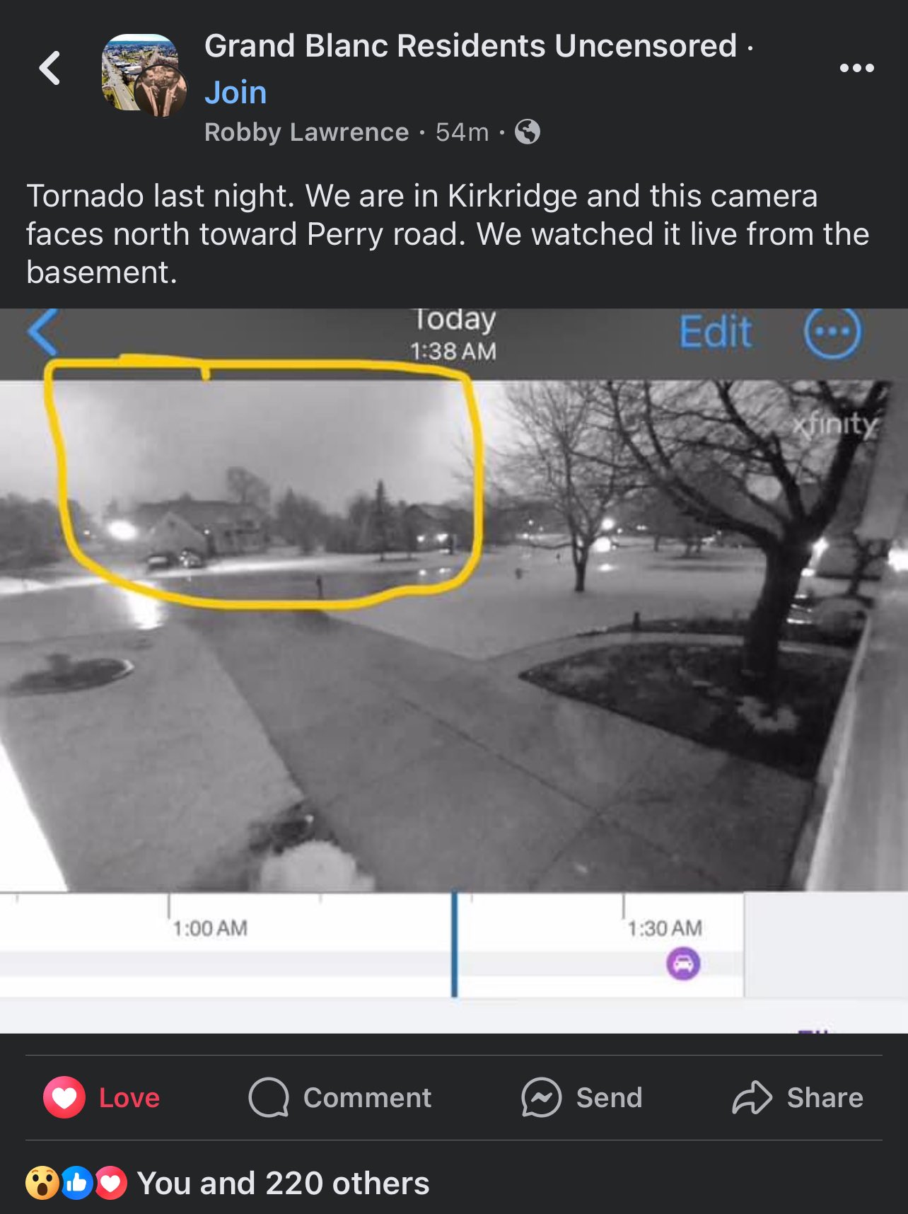
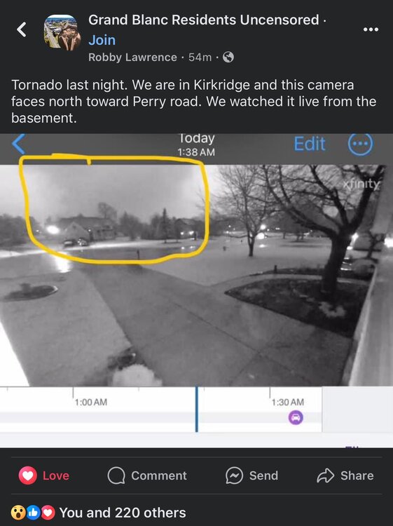
Reed posted a Facebook screencap of it Was pretty damn big, especially for MI
-
Looks to quickly go back to a much warmer than normal pattern with lots of chances for rain and storms. Morch incoming?
-
Right turner heading into Kalamazoo
-
Southern Lower MI is in prime position to get slammed from this LEWP
-
Tornado otg on the La Salle storm too on Reeds stream
-
Storm motion is going way more easterly than forecast which will be more tornado producing
-
That supercell that went up in the Quad Cities CWA has to be one of the fastest formations to SVR Warnings I've ever seen, around 10 mins
-
Initiation going in NE Illinois
-
10% sig tor introduced for South of Chicago into NW Indiana
-
Mesoanalysis looking spicy
-
lol the SPC basically ignored Michigan in the text
-
10% sig for tors and 30% sig for wind in Southern Indiana too
-
Suns coming out here which wasn't supposed to happen til like 3 PM today
-
Spc holds with a slight risk with 5% Tor and 15% sig hail, cams and high res models are showing a higher end event with the 0Z suite however
-

Winter 2023/24 Medium/Long Range Discussion
HillsdaleMIWeather replied to Chicago Storm's topic in Lakes/Ohio Valley
Day 6 and 7 slight risks introduced -
Winter 2023/24 Medium/Long Range Discussion
HillsdaleMIWeather replied to Chicago Storm's topic in Lakes/Ohio Valley
Models are hinting at potential for severe weather on the 27/28th with wrap around snow after -
Winter '23-'24 Piss and Moan/Banter Thread
HillsdaleMIWeather replied to IWXwx's topic in Lakes/Ohio Valley
What are some lesser remembered events that formed you all's love of weather? For me it's January 7th, 2008, going from a zero risk at all locally in the morning to being under a Tornado Watch by the evening and losing our sheds roof to the storms that came through. Event is also notable for having a PDS watch issued in 5% TOR areas. -
February 2024 General Discussion
HillsdaleMIWeather replied to Spartman's topic in Lakes/Ohio Valley
Had an unexpected popup thunderstorm roll through here about 900 pm tonight with pea sized hail and lightning -
2024 Short/Medium Range Severe Weather Discussion
HillsdaleMIWeather replied to Chicago Storm's topic in Lakes/Ohio Valley
Spc kinda dropping the ball with no watch in effect with this many supercells popping -
February 2024 General Discussion
HillsdaleMIWeather replied to Spartman's topic in Lakes/Ohio Valley
GFS finally has storms in the fantasy range again, the most boring stretch is almost over -
Winter 2023/24 Medium/Long Range Discussion
HillsdaleMIWeather replied to Chicago Storm's topic in Lakes/Ohio Valley
The models have been showing a very small winter storm from a clipper Sunday night -
January 22-23 Potential Ice Event
HillsdaleMIWeather replied to HillsdaleMIWeather's topic in Lakes/Ohio Valley
In an odd localized pocket of freezing rain like the event last year, hoping it switches over to regular rain soon -
January 22-23 Potential Ice Event
HillsdaleMIWeather replied to HillsdaleMIWeather's topic in Lakes/Ohio Valley
Not on radar but it's freezing drizzling here already -
January 22-23 Potential Ice Event
HillsdaleMIWeather replied to HillsdaleMIWeather's topic in Lakes/Ohio Valley
IWX upped amounts, calling for a potential Ice Storm Warning upgrade in the AFD -
Might as well get a thread started for this, both the GFS and GEM have been slowly increasing the amount of ice and how long it takes to change to rain, with a swath from Central Illinois to Central Lower Michigan