

HillsdaleMIWeather
-
Posts
3,836 -
Joined
-
Last visited
Content Type
Profiles
Blogs
Forums
American Weather
Media Demo
Store
Gallery
Everything posted by HillsdaleMIWeather
-

Tropical Storm Arlene—40mph/998mb
HillsdaleMIWeather replied to WxWatcher007's topic in Tropical Headquarters
Arlene is no more -
Only got a couple sprinkles tonight lol
-
A couple of heat storms popping up near south bend
-
Spring 2023 Medium/Long Range Discussion
HillsdaleMIWeather replied to Chicago Storm's topic in Lakes/Ohio Valley
At this rate our lawns are all gonna be dead soon lol -
Spring 2023 Medium/Long Range Discussion
HillsdaleMIWeather replied to Chicago Storm's topic in Lakes/Ohio Valley
Long term into early June looks much warmer -
Tired of getting missed south and west lol
-
April 2023 General Discussion
HillsdaleMIWeather replied to PositiveEPOEnjoyer's topic in Lakes/Ohio Valley
Musk and Twitter support said it was intentional, you only get 60 free tweets a month on a bot account and then have to pay for Blue, which the iembot guy obvious can't afford and he won't give an exception to the NWS. -
April 2023 General Discussion
HillsdaleMIWeather replied to PositiveEPOEnjoyer's topic in Lakes/Ohio Valley
I don't know how anyone who's even slightly interested in the weather can defend Musk's changes, he completely broke many warning and spotting dissemination APIs and resulted in the banning of 16 IEMbot accounts for "spam" -
April 2023 General Discussion
HillsdaleMIWeather replied to PositiveEPOEnjoyer's topic in Lakes/Ohio Valley
Pretty moderate snow shower coming through here right now -
April 2023 General Discussion
HillsdaleMIWeather replied to PositiveEPOEnjoyer's topic in Lakes/Ohio Valley
Graupel here rn -
2023 Short/Medium Range Severe Weather Discussion
HillsdaleMIWeather replied to Chicago Storm's topic in Lakes/Ohio Valley
Saturday and Sunday look to give some severe, especially in Eastern Iowa and Western/Central Illinois -
Winter 2022/23 Banter Hangout
HillsdaleMIWeather replied to Chicago Storm's topic in Lakes/Ohio Valley
B, the storms were few and far between but the couple we got were memorable, especially the damn overperforming ice storm -
Severe Weather 4-4-23 and 4-5-23
HillsdaleMIWeather replied to cheese007's topic in Lakes/Ohio Valley
A glorious bust -
Severe Weather 4-4-23 and 4-5-23
HillsdaleMIWeather replied to cheese007's topic in Lakes/Ohio Valley
Some rotation starting to appear on the portion of the line near you rn in Marshall -
Severe Weather 4-4-23 and 4-5-23
HillsdaleMIWeather replied to cheese007's topic in Lakes/Ohio Valley
Sun has actually came out here for the last 30 mins -
Severe Weather 4-4-23 and 4-5-23
HillsdaleMIWeather replied to cheese007's topic in Lakes/Ohio Valley
The cold front already being over the lake is wayyy ahead of schedule and is probably why the risk is a little less now -
Severe Weather 4-4-23 and 4-5-23
HillsdaleMIWeather replied to cheese007's topic in Lakes/Ohio Valley
Goodbye 10% sig, we hardly knew thee -
Severe Weather 4-4-23 and 4-5-23
HillsdaleMIWeather replied to cheese007's topic in Lakes/Ohio Valley
Waiting for that Tornado Watch, wonder when they're gonna do it -
Severe Weather 4-4-23 and 4-5-23
HillsdaleMIWeather replied to cheese007's topic in Lakes/Ohio Valley
Those isolated storms before the main ingredients move in are already packing a punch. Dangerous day ahead. -
Severe Weather 4-4-23 and 4-5-23
HillsdaleMIWeather replied to cheese007's topic in Lakes/Ohio Valley
Day 1 out, 10% sig tor slightly trimmed back -
Severe Weather 4-4-23 and 4-5-23
HillsdaleMIWeather replied to cheese007's topic in Lakes/Ohio Valley
A lot less convection on the map tonight than expected, could this boost todays severe threat? -
Severe Weather 4-4-23 and 4-5-23
HillsdaleMIWeather replied to cheese007's topic in Lakes/Ohio Valley
The other 0Z models still have supercells before the front and are slower, the HRRR has been having a lot of issues today dealing with the warm front placement -
Severe Weather 4-4-23 and 4-5-23
HillsdaleMIWeather replied to cheese007's topic in Lakes/Ohio Valley
Morning AFDs states that the NWS knows about these issues, the HRRR and other CAM are underplaying the environment according to IWX and others, -
Severe Weather 4-4-23 and 4-5-23
HillsdaleMIWeather replied to cheese007's topic in Lakes/Ohio Valley
IWX with one of the most strongly worded AFD's I've seen them issue in years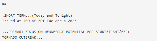
-
Severe Weather 4-4-23 and 4-5-23
HillsdaleMIWeather replied to cheese007's topic in Lakes/Ohio Valley
They mention a possible upgrade could be needed and mention a potential for many sig tors. Could be a long day Wednesday.


