MazooWeather
-
Posts
3,864 -
Joined
-
Last visited
Content Type
Profiles
Blogs
Forums
American Weather
Media Demo
Store
Gallery
Everything posted by MazooWeather
-
" The hurricane still has a few hours left to intensify before it makes landfall." From 5 am discussion
-
Those new blowups are so intense they're completely blocking the eye on satellite
-
They've already found Cat 4 winds lol and with the amount of lightning and blowups it'll probably deepen a bit more
-
They'll probs go Cat 4 at 5 am
-
I've heard people arguing about whether there's dry air of if it's just the radar, anyone got a clear answer?
-
Still 944 on the new pass
-
944 mb extrapolated, 101 knots SFMR
-
Another nice burst of convection just went up
-
Officially a Hurricane Nice blowup going on rn
-
5 AM advisory says they could be too low, now peaks at 90mph
-
Just wanted to say I miss the ALL CAPS days where the NWS would put a nice long synopsis of what's going on and causing an event in warnings/watches/advisories.
-

2023 Short/Medium Range Severe Weather Discussion
MazooWeather replied to Chicago Storm's topic in Lakes/Ohio Valley
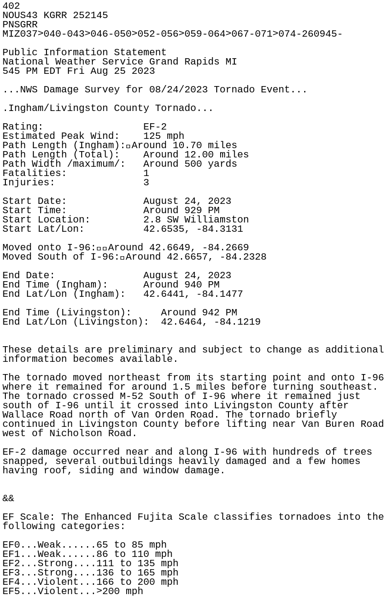
Michigans first killer tornado in years
-
2023 Short/Medium Range Severe Weather Discussion
MazooWeather replied to Chicago Storm's topic in Lakes/Ohio Valley
Webberville got super lucky, the worst part of it went through wooded and cropped areas with insane ground scouring, but even then the city part of it was given an EF-2 -
2023 Short/Medium Range Severe Weather Discussion
MazooWeather replied to Chicago Storm's topic in Lakes/Ohio Valley
Missed to the east here locally, not gonna complain about it -
2023 Short/Medium Range Severe Weather Discussion
MazooWeather replied to Chicago Storm's topic in Lakes/Ohio Valley
Williamston [Ingham Co, MI] Emergency Mngr reports Tstm Wnd Dmg at 24 Aug, 9:35 PM EDT -- Multiple cars flipped over on I-96. Possible tornado. -
2023 Short/Medium Range Severe Weather Discussion
MazooWeather replied to Chicago Storm's topic in Lakes/Ohio Valley
Lots of initiation starting in Michigan -
2023 Short/Medium Range Severe Weather Discussion
MazooWeather replied to Chicago Storm's topic in Lakes/Ohio Valley
Waiting for the watch -
2023 Short/Medium Range Severe Weather Discussion
MazooWeather replied to Chicago Storm's topic in Lakes/Ohio Valley
15% hatched for Michigan and NW Ohio later today -
2023 Short/Medium Range Severe Weather Discussion
MazooWeather replied to Chicago Storm's topic in Lakes/Ohio Valley
Slight risk today for the Eastern MI peeps, MCSville -
2023 Atlantic Hurricane season
MazooWeather replied to Stormchaserchuck1's topic in Tropical Headquarters
Honestly hilarious, at the 11 PM advisory they said it was dying and it immediately blows up and becomes a storm -
2023 Short/Medium Range Severe Weather Discussion
MazooWeather replied to Chicago Storm's topic in Lakes/Ohio Valley
IWX thinking mid week could be MCSville -
2023 Short/Medium Range Severe Weather Discussion
MazooWeather replied to Chicago Storm's topic in Lakes/Ohio Valley
Perry, Michigan was hit by a tornado. Pretty decent damage in half the town. -
2023 Short/Medium Range Severe Weather Discussion
MazooWeather replied to Chicago Storm's topic in Lakes/Ohio Valley
Friday evening bears keeping a close eye on -
lol
-
The Michigan part of the line got completely eaten by the crapvection