

HillsdaleMIWeather
-
Posts
3,725 -
Joined
-
Last visited
Content Type
Profiles
Blogs
Forums
American Weather
Media Demo
Store
Gallery
Posts posted by HillsdaleMIWeather
-
-
Williamston [Ingham Co, MI] Emergency Mngr reports Tstm Wnd Dmg at 24 Aug, 9:35 PM EDT -- Multiple cars flipped over on I-96. Possible tornado.
-
Lots of initiation starting in Michigan
-
 1
1
-
-
Waiting for the watch
-
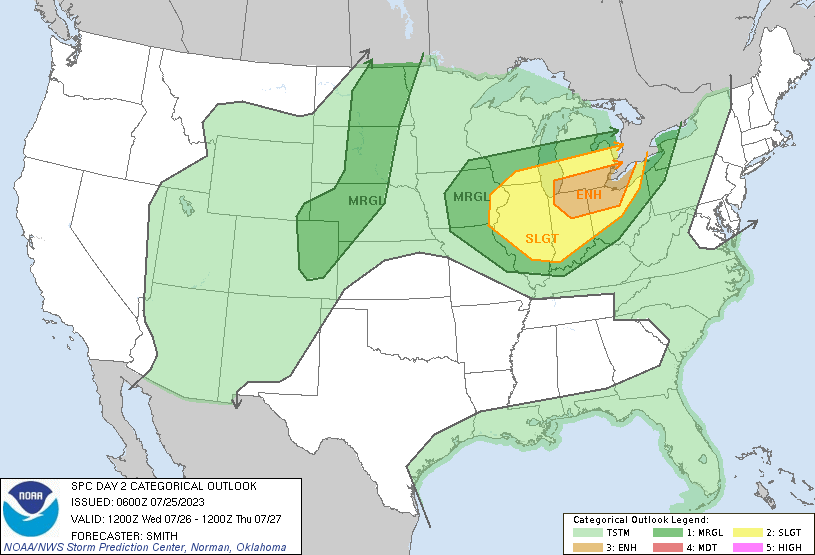
15% hatched for Michigan and NW Ohio later today
-
Slight risk today for the Eastern MI peeps, MCSville
-
6 minutes ago, Boston Bulldog said:
TD-6 has been upgraded to Gert...unfortunately. Needless to say I don't think this one's going to put up a lot of ACE
Tropical Storm Gert Special Discussion Number   7
NWS National Hurricane Center Miami FL       AL062023
1200 AM AST Mon Aug 21 2023

Recent satellite wind-derived data indicated that winds in the
northeast quadrant were a little over 35 kt.  Conventional enhanced
infrared imagery showed cooling cloud tops of -85 Celsius in the
same region of the cyclone.  Accordingly, the depression is
upgraded to a tropical storm on this Special Advisory.

No changes to the forecast track and intensity philosophy are
required.  Since the environment is still expected to be
hostile with very strong westerly shear during the next day or so,
Gert should degenerate into a remnant low later today, and
dissipate by Tuesday.


FORECAST POSITIONS AND MAX WINDS

INIT  21/0400Z 16.7N  55.9W   35 KT  40 MPH
 12H  21/1200Z 16.8N  57.1W   25 KT  30 MPH...POST-TROP/REMNT LOW
 24H  22/0000Z...DISSIPATED

$$
Forecaster Roberts
Honestly hilarious, at the 11 PM advisory they said it was dying and it immediately blows up and becomes a storm
-
1
-
 1
1
-
-
IWX thinking mid week could be MCSville
-
Perry, Michigan was hit by a tornado. Pretty decent damage in half the town.

-
1
-
-
Friday evening bears keeping a close eye on
-
2
-
-

lol
-
1
-
-
The Michigan part of the line got completely eaten by the crapvection
-
Multiple injuries in a campground near Chicago, tree landed on a tent and camper
-
 2
2
-
-
14 minutes ago, Stebo said:
Update, yes and it could be damaging. The line in Wisconsin is accelerating east now.
Right on cue, watch issued
-
@SteboThink it's gonna make it to our neck of the woods?
-
5 minutes ago, Harry Perry said:
ILX always seems to have higher SBCAPE, lot of corn nearby? Some of the highest readings I’ve ever witnessed came from ILX where the dew points always seem to be higher than surrounding areas.
Good old corn sweat, central Illinois has a ton of it
-
 1
1
-
-
Two EF-0s confirmed in Jackson County
-
1
-
-
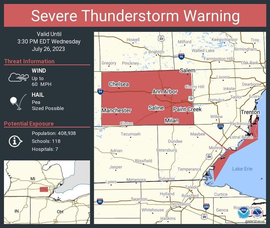
New line developing for the Michigan peeps
-
Aaaaand the award for weirdest polygon of the day goes to DTX
-
The portion of the line that just came through was fun, 50-60 gusts, soaking rain and lots of thunder and lightning, a classic summer storm.
-
1
-
-
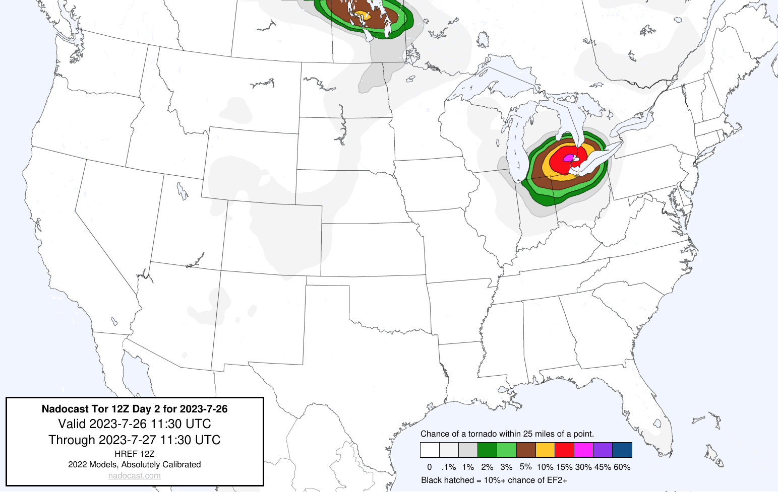
32 minutes ago, nvck said:
nadocast day2 is very bullish on the tornado potential in se michigan/Detroit area tomorrow... highly doubt that this verifies but will be interesting to see
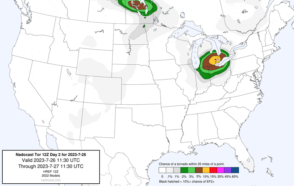
lol

-
2
-
1
-
-
Enhanced introduced
5 TOR, 30 wind
-
IEMbot being killed on Twitter again is so damn annoying
-
27 minutes ago, nwohweather said:
Really watching these storms as they approach Ohio. It seems the best environment is Coldwater to Fort Wayne & Findlay to Toledo. Anything in that square is pretty darn primed at the moment, seeing LI's around -8 and even -9 with LL lapse rates at 8° C/KM. Shear is solid but helicity is pretty low, a little higher around Hillsdale & Lenawee Counties so maybe something could spin up around there if it's discrete.
Jinxed me lol, the storm moving into my county imploded
-
Lots of storms popping up behind the current ones

2023 Short/Medium Range Severe Weather Discussion
in Lakes/Ohio Valley
Posted
Missed to the east here locally, not gonna complain about it