

HillsdaleMIWeather
-
Posts
3,725 -
Joined
-
Last visited
Content Type
Profiles
Blogs
Forums
American Weather
Media Demo
Store
Gallery
Posts posted by HillsdaleMIWeather
-
-
21 minutes ago, weatherbo said:
Two new accounts today that post identical to Palm.
Who could it ever be?
What you mean rating a snowfall map weenie within an hour on your first day being here isn't normal behavior?
-
 4
4
-
-

Presented without comment for the committee.
-
 2
2
-
 6
6
-
-
Areas of North Dakota reporting one inch of ice accretion with lots of damage
-
 1
1
-
-
11 minutes ago, michsnowfreak said:
Interesting. How is that different from a Snow Squall Warning i wonder?
My best guess is maybe squalls that are stronger or last longer than normal?
-
1
-
-
Latest radar scope update says the NWS can now issue Snow Squall Emergencies
That will be an interesting first
-
 1
1
-
-
IWX expanded the lake effect advisories to another row of counties
God I miss iembot on twitter at times like this, I just learned the bots are available on Mastodon at least
-
1
-
-
Around the first of the year will at least be a stormier pattern if current model trends hold
-
1
-
-
The severe weather event down south way overperformed today
-
2
-
-
-
I wish I had known about here years ago when AccuWeather was a thing, as much as that place was fun to track winter storms with fellow weenies it would've been nice to be here too at the same time
-
12z GFS and gem basically held from their morning runs
-
1 minute ago, Toro99 said:
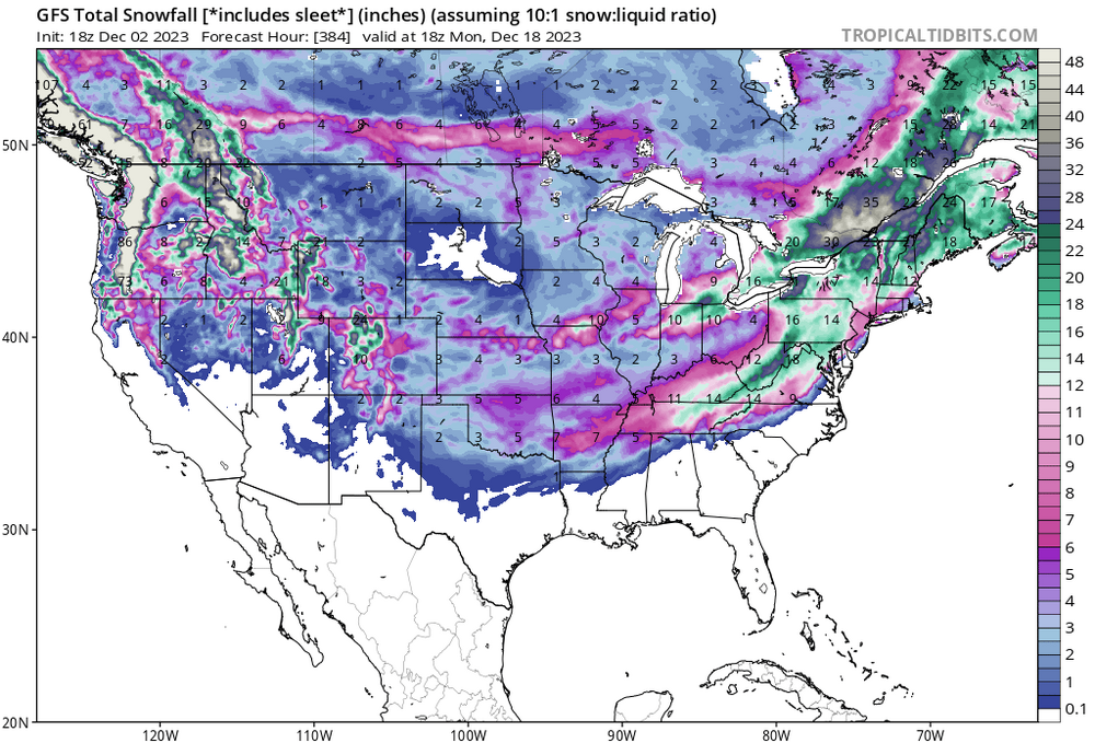
Posting 384hr maps should be banned, or suspended for a month. Maybe suspend for the number of hours on the posted map
It was pure weenie posting, I'm not saying that's going to happen lmao
-
1
-
-
LOCK
IT
IN
-
2
-
1
-
1
-
-
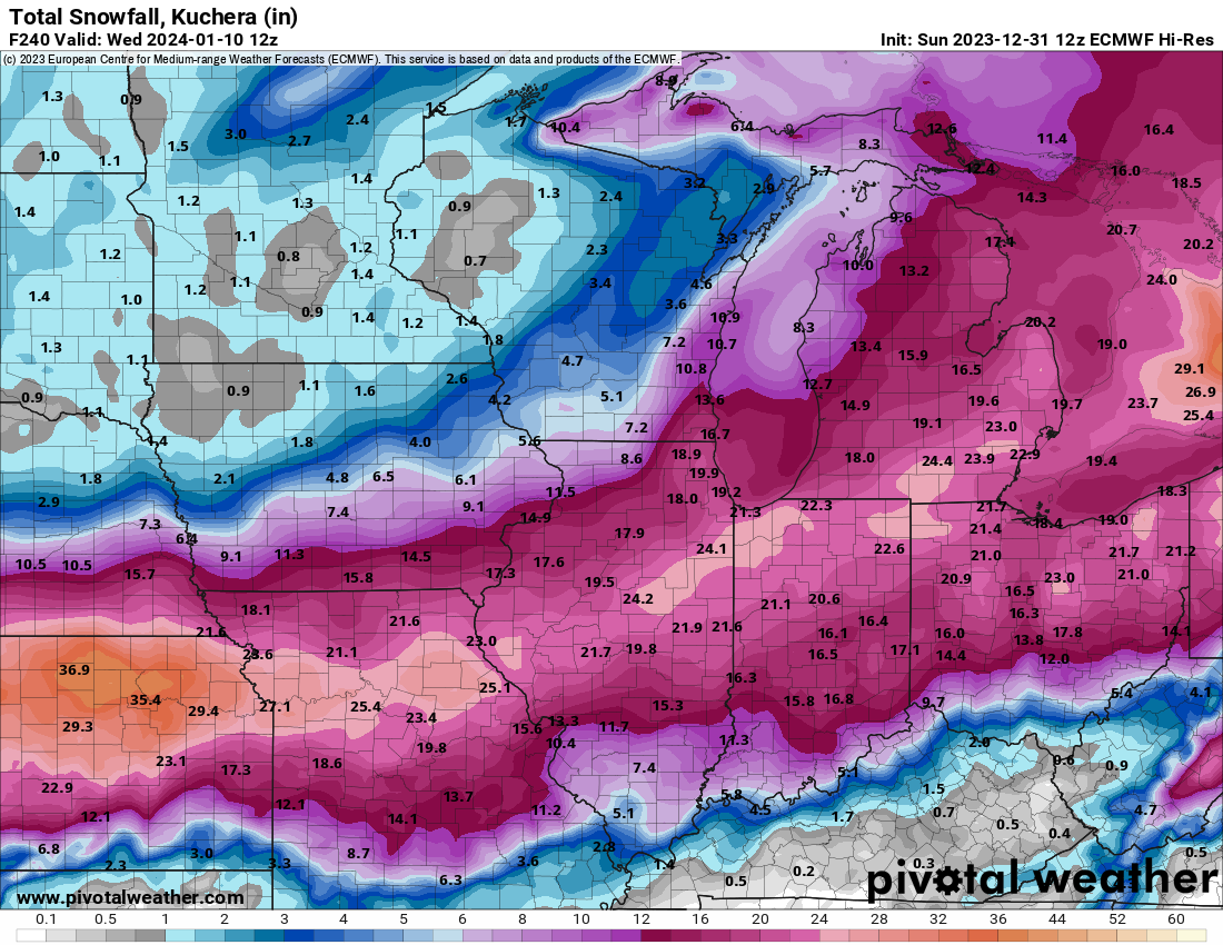
If y'all wanna see some weenie shit look at New York

-
Lock
It
In

-
2
-
2
-
-
Ground is completely covered, feeling like winter here
-
4
-
-
First flakes mixing with rain and sleet here
-
You don't want snow on Halloween because you think it will ruin the season
I don't want snow on Halloween because I can't dress as Michael Myers to give kids candy and be warm
We are not the same
-
1
-
3
-
-
GFS would give widespread severe weather across Michigan on the evening of the 27th
-
1
-
-

lol
-
2
-
1
-
1
-
-
2 hours ago, Malacka11 said:
Lmao just wait until PalmBro drops the mic right in the middle of an 18z SE/weaker run. I almost desintegrated at the molecular level on one such occasion last year
He's going to bask in the schadenfreude when 5 days of blizzard runs fall apart into a mediocre clipper two days out and we're all pissed, guaranteed.
-
3
-
-
55 minutes ago, hardypalmguy said:
There's a reason there's hundreds of songs about beaches and palm trees yet zero about snow, ice and cold.
Have you somehow avoided all Christmas music for decades?
-
1
-
-
If we gotta deal with warm temps for longer, at least give us some fall naders!
-
1
-
1
-
-
If medicanes keep becoming a bigger threat over the next decade, I imagine the EU would start a forecasting agency for them.
Rest in peace to all those who died, Libya was a terrible place for this to hit
-
1
-


Winter 2023/24 Medium/Long Range Discussion
in Lakes/Ohio Valley
Posted
0Z GFS continues to look juicy