

HillsdaleMIWeather
-
Posts
3,721 -
Joined
-
Last visited
Content Type
Profiles
Blogs
Forums
American Weather
Media Demo
Store
Gallery
Posts posted by HillsdaleMIWeather
-
-
The cold front already being over the lake is wayyy ahead of schedule and is probably why the risk is a little less now
-
Goodbye 10% sig, we hardly knew thee
-
 1
1
-
 1
1
-
-
Waiting for that Tornado Watch, wonder when they're gonna do it
-
Those isolated storms before the main ingredients move in are already packing a punch. Dangerous day ahead.
-
1
-
-
Day 1 out, 10% sig tor slightly trimmed back
-
A lot less convection on the map tonight than expected, could this boost todays severe threat?
-
3 minutes ago, Harry Perry said:
00z HRRR shows a line of scattered crap-vection moving through around 9-10am just prior to fropa. Looks like the front has sped back up and clears the area by 2pm. Doesn’t look like much of a threat on that particular model around here.
The other 0Z models still have supercells before the front and are slower, the HRRR has been having a lot of issues today dealing with the warm front placement
-
1
-
-
21 minutes ago, WxSynopsisDavid said:
Something just appears off with these runs this morning. Mixing issues and capping issues are more prevalent right now. Concerning Wednesday, the HRRR has very little STP and parameters for the OH/TN Valley which seems odd.
Morning AFDs states that the NWS knows about these issues, the HRRR and other CAM are underplaying the environment according to IWX and others,
-
2
-
-
IWX with one of the most strongly worded AFD's I've seen them issue in years
-
4
-
-
7 minutes ago, andyhb said:
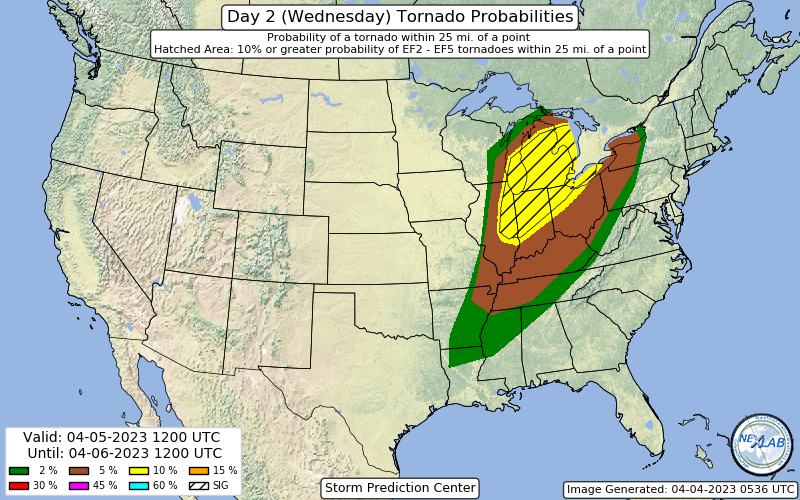
Huge 10% hatched in the latest D2 for Wednesday, including some seriously large population centers. Chicago and east could get very interesting from early on Wednesday.
They mention a possible upgrade could be needed and mention a potential for many sig tors. Could be a long day Wednesday.
-
Line is restrengthening in Northern Indiana rn
-
Chicago now warned for 90 mph, TOR possible
-
Tornado on the ground in the line right now
-
Might need to extend the thread into the 5th too, models are showing MI and IN could be under the gun the next day
-
4 minutes ago, SolidIcewx said:
Nice line of storms moving NE into the Detroit metro area. Lenawee county under SVTN warning
Got missed by golf balls five miles to the east
-
Nasty pop up supercell with big hail headed my way from near Angola
-
Major expansion of the moderate risk on the new outlook
-
1
-
-
-
The Indiana tornado drill making my weather radios all go off with a warning tone scared the hell out of me lmao, thought the world was ending
-
1
-
3
-
-
Getting used to the later model runs again sucks
-
2
-
-
18Z GFS with a new solution that slows the weekend storm down and keeps it all snow across a wide area
-
Got 10 inches of pure sludgey concrete. Credit to the NWS offices, the six to ten call panned out well
-
1
-
-
Getting one last impressive burst here
-
Snow is drying up on radar rapidly from the west and south as the low moves away, if only it was a couple hours slower
Severe Weather 4-4-23 and 4-5-23
in Lakes/Ohio Valley
Posted
Sun has actually came out here for the last 30 mins