

HillsdaleMIWeather
-
Posts
3,560 -
Joined
-
Last visited
Content Type
Profiles
Blogs
Forums
American Weather
Media Demo
Store
Gallery
Posts posted by HillsdaleMIWeather
-
-
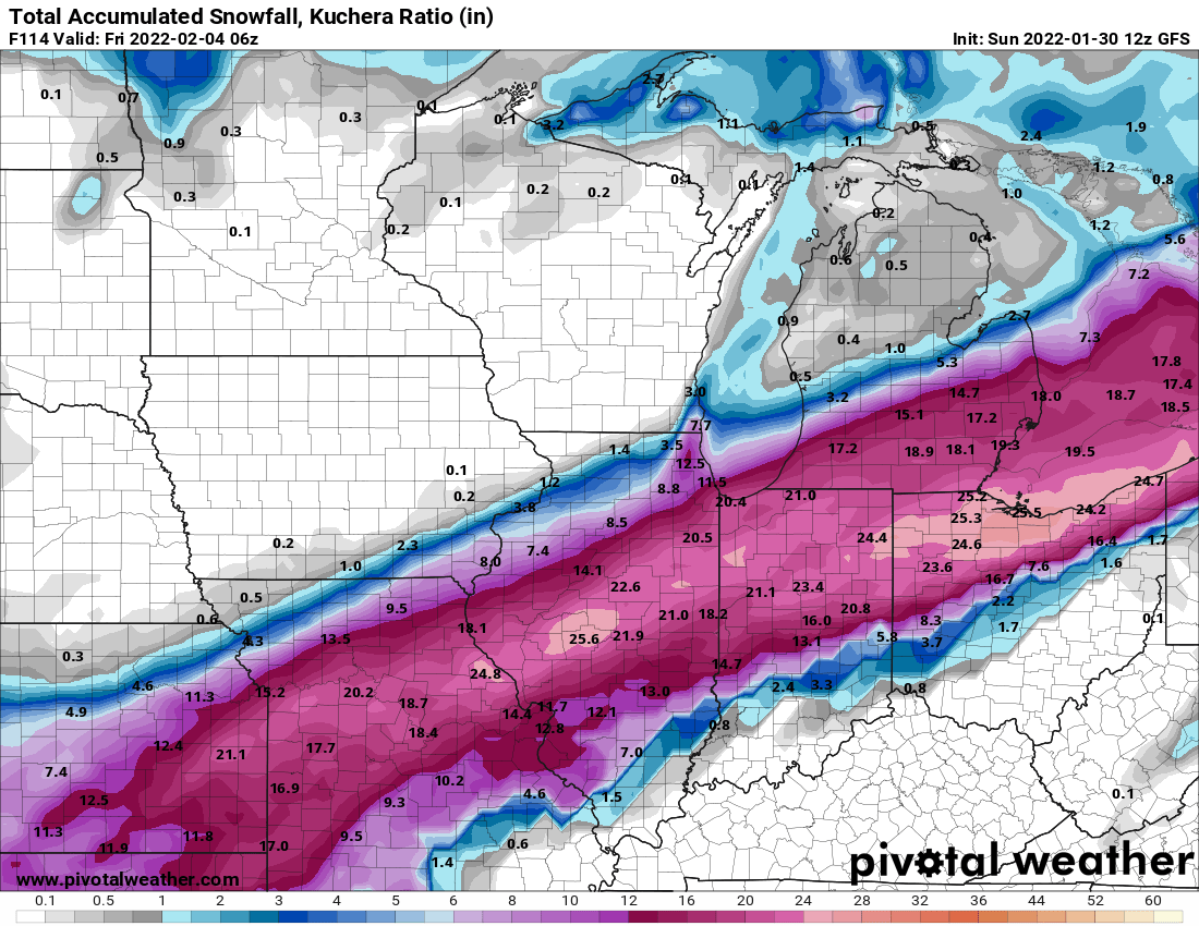
GRR winter storm watch issued, calling for 8-12 for now, DTX with a similar watch calling for 8-14 meanwhile the 06Z NAM is even more juiced
-
 1
1
-
-
1 minute ago, Hoosier said:
Euro actually cut the highest snow amounts compared to 12z run. It's all relative though.
We're starting to get into the run to run noise for exact totals phase, gonna be interesting to see the ensembles though
-
Wetter than the 18Z run but not as crazy as the 12Z run
-
 1
1
-
-
-
-
With rates and winds like the models are predicting, do the Mets here think some places could reach blizzard warning criteria?
-
-
Can't wait to read how different the afternoon GRR afd sounds in about two hours lmao
-
2
-
 2
2
-
-
Compared to the 06Z run, it's actually ending up very very slightly north
-
2
-
-
1 minute ago, Baum said:
Pretty clear GFS is a northern outlier at this point.
Considering the NAM is north, and the 6Z Euro also came north, are you sure about that?
-
GFS ensembles remain slightly north of the operational
-
1
-
-
-
Further into the run is north north in general, Chicago looks to actually get some decent stuff
-
FWIW the 06Z Euro is a bit north and more amped, at least for as far as it goes on Pivotal Pro
-
1
-
-
1 minute ago, RogueWaves said:
GRR

They will latch onto one single model (any of them) and ride it over a cliff. Even at that, while the Euro shafts GR proper, it still clips their far SE counties pretty good and would require headlines for sure, but to read the AFD nobody is getting snow in their CWA. This happened with last Feb's storm as well. My former residence in Calhoun is one of those ignored by that office. They skipped any Watch, went with the purple paint, then after it was snowing sideways and beyond obvious we were getting storm level hit, they hoisted a warning.
I don't normally like to crap on the NWS offices, but them writing literally one small paragraph about such a potentially impactful storm because of one run of the Euro that doesn't even have support of the majority of its ensembles just seems a little silly.
-
1
-
-
GRR is riding the Euro hard while IWX and DTX say it is way too early to call
-
1
-
-
06Z GFS is a tad bit north, and is much more spread the wealth, everyone from Indy to the Thumb and Chicago gets well above warning criteria
-
1
-
-
2 minutes ago, StormChaser4Life said:
Are you throwing in the towel now? Don't give up on me yet. If you give up, I will. I'm trying to give it till Mon. But would like to see some model support in favor of GFS. Odds definitely seem against us.
Honestly as of right now the GFS does have more support, the NAM is similarly looking at 84 hours and the GEM came north. The Euro is being uncharacteristically weird rn, it usually doesn't flip flop this much.
-
2
-
-
2 minutes ago, Floydbuster said:
Can you translate that?
The gif posted above is of a football kicker punting
Punting around here and in weather circles usually means you're giving up on the highest snow being in your area or even getting anything.
-
1
-
-
Not really like to punt considering the Euro is bouncing massively run to run lmao
-
12 GEM

vs 0Z GEM

-
The 0Z GEM is coming in with a pretty decent shift to the north
-
1
-
-
Times like this make me wish the WPC still did the model diagnostic discussions lmao
-
1
-
-
Punting this early out for anybody is a bad idea, we still have lotsa model runs to go
-
1
-
.png.d0386cecfbd0da68bdbcc014fa51c08d.png)
.png.16f03aa813b1850fd8cefd467ae27d6c.png)
.png.724195b5e056434f650f359bf8674d45.png)
Feb 1-3rd GHD III Part 2
in Lakes/Ohio Valley
Posted
IWX with a very scary worded watch