

MazooWeather
-
Posts
3,864 -
Joined
-
Last visited
Content Type
Profiles
Blogs
Forums
American Weather
Media Demo
Store
Gallery
Posts posted by MazooWeather
-
-
Storm that popped up overhead went from nothing to producing 80 mph wind gusts immediately
-
 2
2
-
-
Tne SPC upgraded Oklahoma for wind to enhanced at 01Z but not where there's an ongoing tornado outbreak lol
-
2
-
-
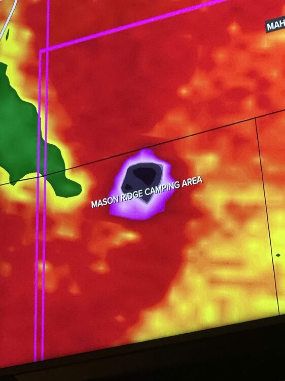
Looks like it direct hit a campground
-
 3
3
-
-
Spc discussion on it says the environment out ahead of it has fully recovered, this might be the storm of the event, definitely a violent tornado.
-
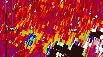
Monster debris ball and cc drop near Gosport IN
-
The fact we've managed to get a couple of big ones in what should have been a completely rained out event just shows how this event could've been something historical if things went a little differently
-
3
-
 2
2
-
-
2 minutes ago, Powerball said:
Even the heavy rainfall that was projected is busting for the MI crew in the most LOLtastic fashion
All-around tragic (but, in a good way)...
Yeah, the blob of rain is only really hitting the first row of counties and is nowhere near as heavy as predicted lol
-
Slight risk introduced for today for Michiana, 5% TOR
-
"A few strong tornadoes" 100% verified yesterday
-
holy shit
-
Possible tornado moving onshore near Holland, MI
-
Gonna need a downstream watch soon, environment in Michigan the storms are gonna be entering is juiced
-
17 minutes ago, Harry Perry said:
Yeah we bust on this one, have some stratiform rain in the sights down this way.

The rain is decaying pretty fast
-
1 hour ago, frostfern said:
Todays HRRR modeled today’s convection pretty good and it has all of western lower MI under the gun tomorrow evening. The caveat is it’s Michigan.
The strength of the low might have a lot more of influence. It’s more of a spring-like system with better wind fields than you typically see in the summer. Stronger mid-level westerlies may shunt the leftover debris east and keep mid-level lapse rates steep. But, it’s Michigan, so who knows.
Looking like it's just gonna be some rain that should be long gone by daybreak instead of sustained overnight development, could be a rocking day
-
1
-
-
CAMS show a violent atmosphere in Western MI tomorrow night, if we don't get rained out could be a high end event for around here
-
3
-
1
-
-
PDS Severe Thunderstorm Warning for the SW Chicago burbs
-
1
-
-


finally some action soon
-
5
-
-
What a lovely introduction to Kalamazoo storm wise, probs was close to 65mph here. Thankfully didn't lose power.
-
2
-
-
29 minutes ago, A-L-E-K said:
grateful for the comma head graze job as we could use the rain
looks like you're probs getting 70 mph gusts rn
-


Gonna be a long couple of days, Monday looks particularly like it has a lot of chances for long track tornadoes.
-
2
-
-
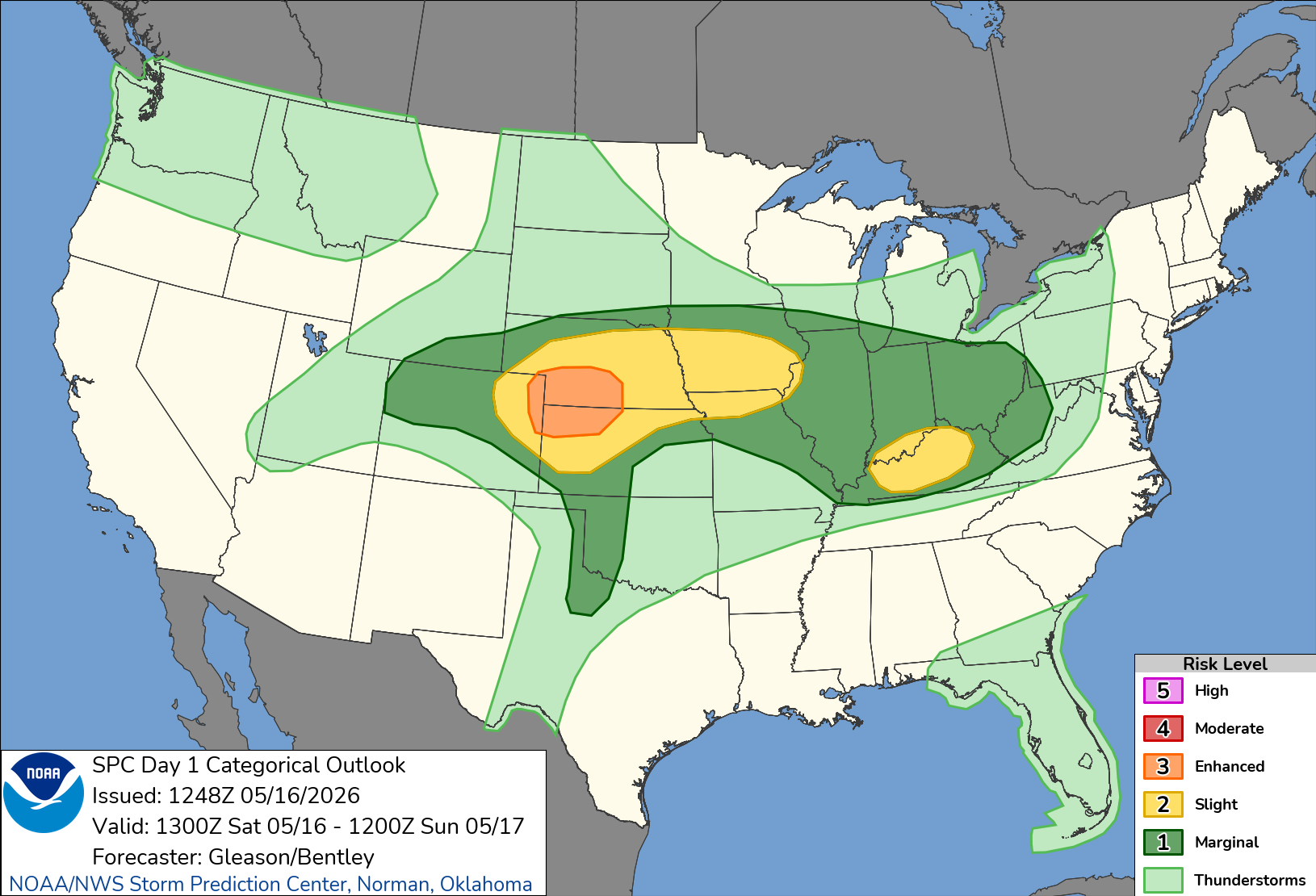
SPC made an oopsie last night on the 01Z outlook


First ever 0% CIG1 lol
-
 3
3
-
-
5 hours ago, Harry Perry said:
You’re only 20 minutes away. We’ll have to link up. I’m over in the zoo all the time.
For sure! It's weird having options of stuff to do compared to Hillsdale lol
-
1
-
-
Moved today, new name and everything.
-
8
-
-
Looks like it just barely missed the afb but many structures nearby are destroyed
-
1
-

July 2026 General Discussion
in Lakes/Ohio Valley
Posted
The amount of rain, thunder and cloud to ground lightning earlier tonight was absolutely wonderful