

HillsdaleMIWeather
-
Posts
3,560 -
Joined
-
Last visited
Content Type
Profiles
Blogs
Forums
American Weather
Media Demo
Store
Gallery
Posts posted by HillsdaleMIWeather
-
-
5 minutes ago, WeatherMonger said:
SPC has the damage down as wind damage, I doubt a brief touchdown is what occurred.
Until a survey is done they put it in as what the NWS sends it as, some of the wind damage from a couple days ago was changed to tornadoes eventually.
-
SVA issued for the northwestern part of IWX's CWA, storms are popping rn
-
We have clearing here finally, sun is peaking out. IWX is saying storms should fire soon and could be tornadic for a few hours.
-
4 minutes ago, Malacka11 said:
I might really be jumping the gun on this one, but I think we're gonna go chase in northern Indiana, see if we can find anything
You should definitely have enough time to get there, it's still raining and the lull hasn't started yet
-
 1
1
-
-
SPC saying we could have some LLJ fueled naders tomorrow evening
-
Saturday has a good setup for Severe Weather across lower Michigan and Northern Indiana, only real limiting factor will be instability.
-
An event like this at least shows that lead time saves lives, it sounds like a lot of people took shelter before it hit
-
1
-
-
9 minutes ago, Malacka11 said:
Frivolity, but what app is this?
Radarscope
-
Tornado warned hook echo near Van Buren Michigan
-
1
-
-
1 minute ago, Chicago Storm said:
Just got hit by a tornado on I-355 in Woodridge.
.You ok!?
-
SPC coordinating a new downstream watch
-
20 minutes ago, Chinook said:
It looked like the rotation continued near Jonesville, but I don't know if any tornado ever happened.
Sounds like it probably did and I got spared by like 5 miles
-
 1
1
-
-
Dodged a bullet here but theres some damage in Branch County, hope everyone is ok
-
Tornado just hit Coldwater Airport in Michigan
-
 1
1
-
-
TOR Possible in NW Ohio, has decent rotation atm
-
Baseball size hail in Berrien County MI rn
-
-
We have initiation around Chicago and in NW Indiana
-
The 80% MD has expired and it looks like no watch still
-
Place bets if they go tornado or severe watches
-
MCV has formed out west as expected and is wickedly strong
-
Could these storms tonight help set down additional outflow boundaries for the stuff tomorrow?
-
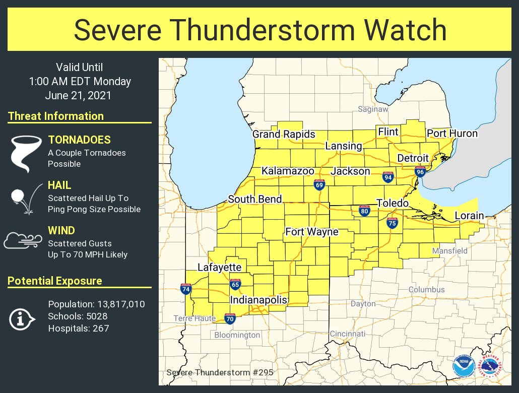
Surprise Severe Thunderstorm Watch time!
-
Rotation is tightening up on it right as it heads towards town
Late June Heavy Rain/Severe Threats
in Lakes/Ohio Valley
Posted
That second line is booking it northeast, could cause some nice spin ups