

HillsdaleMIWeather
-
Posts
3,725 -
Joined
-
Last visited
Content Type
Profiles
Blogs
Forums
American Weather
Media Demo
Store
Gallery
Posts posted by HillsdaleMIWeather
-
-
10 minutes ago, frostfern said:
Have to wait. There’s still a lot of CIN, but maybe the nocturnal low level jet breaks it. I’m guessing mostly garden variety, but with isolated hail or spinups possible given the shear. Don’t need a derecho IMBY.
Storm motion would have the couple of counties to your south like me getting slammed, fun night ahead
-
4 minutes ago, frostfern said:
Miss south for Michigan unless the bookend peels north. Meh.
Models show it building up into Wisconsin as it moves further east in 2-3 hours
-
New hot towers going up on IR too
-
Considering the mcs was originally forecast to die before reaching Lansing, I'll gladly take this
-
And now hitting 80 in Muskegon
-
Grand Rapids area getting 70 mph winds rn
-
Enhanced risk for 30% wind introduced for our WI friends
-
 1
1
-
-
There's a lot of hand wringing going on in the media about the Livonia tornado being "unwarned" since it was only a SVR with a TOR possible tag, some media people are saying tor possible warnings should just be tornado warnings. What's you all's thoughts?
-
Sadly the Livonia tornado killed a two year old baby from a tree hitting a house
-
 1
1
-
-
3 hours ago, Cartier God said:
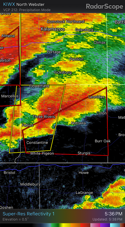
Some more pictures of the Colon/Sherwood tornado, all taken from M-66. Officially rated a 130mph EF2. Path length 19.52 miles and 950yds wide.


.Wonderful pics, very very lucky it didn't hit anywhere big at peak strength
-
1
-
-
-
23 hours ago, HillsdaleMIWeather said:
If we somehow outperform the OK event that would be something

-
 4
4
-
-
That tornadic storm that moved into me I think only died because of crossing the front which is parked over the county, I was sweating bullets
-
2
-
-
-
PDS TOR for me
-
4
-
-
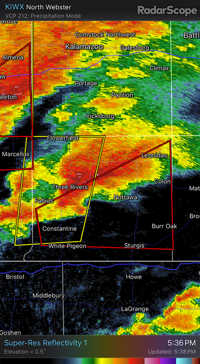
How has IWX not put a TORR on this?
-
Just now, frostfern said:
Making a right turn too
-
That hook is headed right into the Kalamazoo area
-
Berrien County storm looks spicy
-
TOR for OKC
-
The OKC supercell turned into a line instead
-
There's also some new cells going up southwest of the line now
-
If we somehow outperform the OK event that would be something
-
Okeene cell with a strong circulation is about to go
-
3
-

2024 Short/Medium Range Severe Weather Discussion
in Lakes/Ohio Valley
Posted
They gave it the confirmed tag