

HillsdaleMIWeather
-
Posts
3,725 -
Joined
-
Last visited
Content Type
Profiles
Blogs
Forums
American Weather
Media Demo
Store
Gallery
Posts posted by HillsdaleMIWeather
-
-
At this rate if we keep having warm ups and no sustained cool offs, the lake effect belts could have another full winter of dealing with LES
-
 2
2
-
-
i want to believe

-
 2
2
-
1
-
-
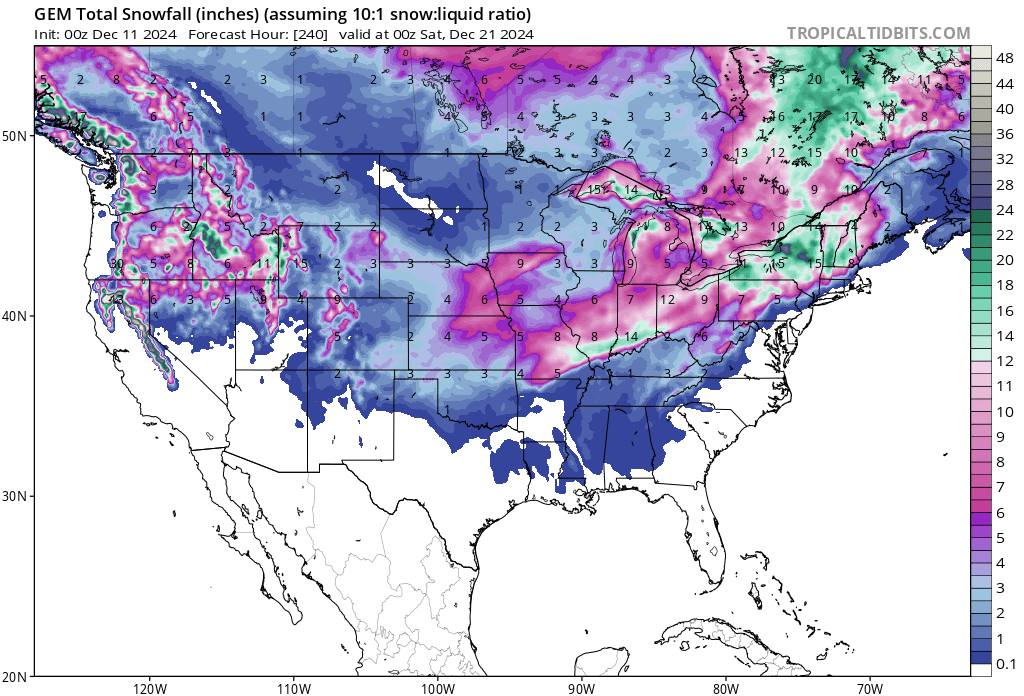
LOCK IN THE GEM
-
2
-
-
Manifesting another Christmas Eve blizzard rn dont worry
-
 1
1
-
-
Recorded it at its peak for your viewing pleasure
-
2
-
 1
1
-
-
One of the craziest bursts of snow and wind with thunder and lightning I've seen in my life here
Just probably got a quick inch in 15 mins
-
2
-
1
-
-
GFS has active period after next week
-
Praying for first flakes before December
-
3
-
-
What's your all's thoughts on the SPC testing double hatching in house to delineate even higher probabilities than they have right now. Truthfully I think it might confuse people not familiar with the wording even more.
-
10 minutes ago, canderson said:
Roof of Tropicana might not survive the night.
There's people sheltered inside there right now, that's not good
-
1
-
-
Looks like recon might of missed the center
-
-
Lots of lightning in the eyewall rn, might not be done yet
-
Just now, Radtechwxman said:
Any new wind data from recon?
AF recon is lagging
-
8 hours ago, IWXwx said:
@HillsdaleMIWeatherThat cell that's been periodically dropping them across Northeast IN is in your neighborhood. You on it?
I must have been on the opposite side of it cause I see a bunch of videos from Camden MI of the tornado that went through
-
1
-
-
52 minutes ago, IWXwx said:
@HillsdaleMIWeatherThat cell that's been periodically dropping them across Northeast IN is in your neighborhood. You on it?
Had a nice wall cloud briefly and then died
-
https://x.com/JayLesykWX/status/1838687526623809990
Injuries and damage from the LaGrange tornado
-
-
Unexpected early morning tornadoes time
-
This system in a nutshell

-
1
-
 4
4
-
-
CC drop near Sturgis MI, unwarned
-
-
Large Tornado on the ground at Ohare
-
Chicago Midway Airport reporting a Tornado

Winter 2024-25 Medium/Long Range Discussion
in Lakes/Ohio Valley
Posted
Don't worry guys we'll get our snow and ice quota in March or April when we're all ready for severe weather instead