Blizzard of 93
-
Posts
13,024 -
Joined
-
Last visited
Content Type
Profiles
Blogs
Forums
American Weather
Media Demo
Store
Gallery
Everything posted by Blizzard of 93
-
Central PA Winter 2024/2025
Blizzard of 93 replied to Voyager's topic in Upstate New York/Pennsylvania
The Euro has not wavered for the past day or two, run after run for Warning event for southern PA. UKMET steady too & Canadian has had a solid general idea. I expect the GFS to fall back in line with getting southern PA into at least Warning level Tuesday totals. After that, let’s take it one wave at a time. -
Central PA Winter 2024/2025
Blizzard of 93 replied to Voyager's topic in Upstate New York/Pennsylvania
6z Euro remains steady with a Warning snow event Tuesday for southern PA. -
February 11-12; 12-13: Are they real??
Blizzard of 93 replied to stormtracker's topic in Mid Atlantic
6z Euro is nice indeed! -
February 11-12; 12-13: Are they real??
Blizzard of 93 replied to stormtracker's topic in Mid Atlantic
0z EPS for the 24 hour period of this event. Very much in the game.
-
Central PA Winter 2024/2025
Blizzard of 93 replied to Voyager's topic in Upstate New York/Pennsylvania
0z Euro is steady as she goes for Tuesday’s chance. -
February 11-12; 12-13: Are they real??
Blizzard of 93 replied to stormtracker's topic in Mid Atlantic
Here is the Ukie for just this event -
Central PA Winter 2024/2025
Blizzard of 93 replied to Voyager's topic in Upstate New York/Pennsylvania
Here is the Ukie through 168 hours at the end of its run through next Thursday evening. -
February 11-12; 12-13: Are they real??
Blizzard of 93 replied to stormtracker's topic in Mid Atlantic
Agreed, here is the Ukie through 168 hours. -
Central PA Winter 2024/2025
Blizzard of 93 replied to Voyager's topic in Upstate New York/Pennsylvania
The 0z GFS & Canadian both have different ways of getting it done with the multiple chances over the next 10 days. Most of us wouldn’t complain if we are sitting on 8 to 10 inches of snow by next Sunday. -
Central PA Winter 2024/2025
Blizzard of 93 replied to Voyager's topic in Upstate New York/Pennsylvania
-
Central PA Winter 2024/2025
Blizzard of 93 replied to Voyager's topic in Upstate New York/Pennsylvania
CTP has a great discussion on the weekend mix event & the 2 chances next week. -
Central PA Winter 2024/2025
Blizzard of 93 replied to Voyager's topic in Upstate New York/Pennsylvania
Just another day of epic 15 & 16 day ensemble runs by all 3 globals. Day after day… run after run… -
Central PA Winter 2024/2025
Blizzard of 93 replied to Voyager's topic in Upstate New York/Pennsylvania
It’s hard to say, but there is a good wall of Highs to the north that could steer the next wave enough for us to score another win. -
Central PA Winter 2024/2025
Blizzard of 93 replied to Voyager's topic in Upstate New York/Pennsylvania
MDT recorded .1 of snow today. -
Central PA Winter 2024/2025
Blizzard of 93 replied to Voyager's topic in Upstate New York/Pennsylvania
Lol, why stop there, here’s the entire 18z GFS run through 384 hours… -
Central PA Winter 2024/2025
Blizzard of 93 replied to Voyager's topic in Upstate New York/Pennsylvania
Talk about training time… Line ‘em up !!! -
Central PA Winter 2024/2025
Blizzard of 93 replied to Voyager's topic in Upstate New York/Pennsylvania
Epic GFS run underway with 3 mostly snow events next week…WOW!!! -
Central PA Winter 2024/2025
Blizzard of 93 replied to Voyager's topic in Upstate New York/Pennsylvania
Same in Marysville. -
Central PA Winter 2024/2025
Blizzard of 93 replied to Voyager's topic in Upstate New York/Pennsylvania
Must have been a brief period of snow & then mostly sleet here. Now some light freezing rain. All surfaces coated. -
Central PA Winter 2024/2025
Blizzard of 93 replied to Voyager's topic in Upstate New York/Pennsylvania
0z GFS & Canadian are looking good for next Tuesday’s snow chance. -
Central PA Winter 2024/2025
Blizzard of 93 replied to Voyager's topic in Upstate New York/Pennsylvania
Dew points in northeast PA are still in the single digits at this hour. Most of the rest of PA has dews in the teens. -
Central PA Winter 2024/2025
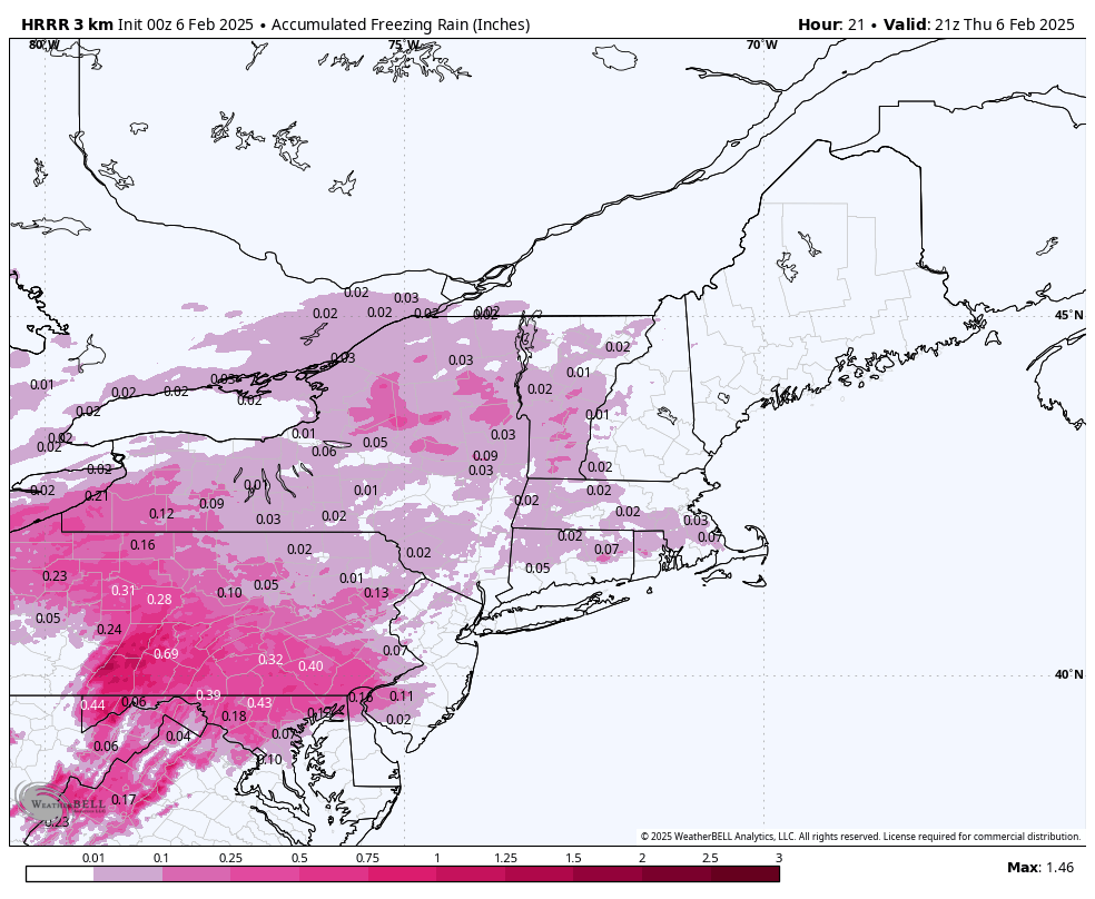
Blizzard of 93 replied to Voyager's topic in Upstate New York/Pennsylvania
Here is the 0z HRRR sleet & freezing rain for tomorrow.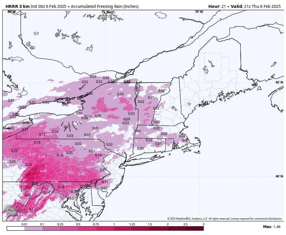
-
Central PA Winter 2024/2025
Blizzard of 93 replied to Voyager's topic in Upstate New York/Pennsylvania
We have a chance to get to average or above If we score a 6 to 8 inch Warning level event next week. Follow that up with at least some front or back end snow from the follow up waves later next week/early the following week, we will be well on our way. Then, we big game hunt when the blocking pattern sets in a little later in the month to put us over the top. -
Central PA Winter 2024/2025
Blizzard of 93 replied to Voyager's topic in Upstate New York/Pennsylvania
Ho-hum… just another 16 day ensemble run with double digit snow in the LSV. Day after day of this, again, which is super rare. 18z GEFS -
Central PA Winter 2024/2025
Blizzard of 93 replied to Voyager's topic in Upstate New York/Pennsylvania
Wow, you are turning over a new leaf, Lol!