Blizzard of 93
-
Posts
13,037 -
Joined
-
Last visited
Content Type
Profiles
Blogs
Forums
American Weather
Media Demo
Store
Gallery
Everything posted by Blizzard of 93
-
Central PA Winter 2024/2025
Blizzard of 93 replied to Voyager's topic in Upstate New York/Pennsylvania
6z Euro AI is also full of multiple potential Winter opportunities over the next 2 weeks. -
Central PA Winter 2024/2025
Blizzard of 93 replied to Voyager's topic in Upstate New York/Pennsylvania
Here’s the 0z Euro AI for Valentine’s Eve. -
Central PA Winter 2024/2025
Blizzard of 93 replied to Voyager's topic in Upstate New York/Pennsylvania
Lol, I went there! -
Central PA Winter 2024/2025
Blizzard of 93 replied to Voyager's topic in Upstate New York/Pennsylvania
The rest of the 0z Euro AI run looks like it was run out of my basement. Drool worth for the 11th -
Central PA Winter 2024/2025
Blizzard of 93 replied to Voyager's topic in Upstate New York/Pennsylvania
The 6z GFS has 5 different Winter Storm chances over the next 16 days. Most are snow to mix scenarios, but we would build a little glacier if this run were to verify. Too many maps (lol, yes I said it) to post each individual threat. Here is the 16 day snow map just to give a general idea of the potential this run. -
Central PA Winter 2024/2025
Blizzard of 93 replied to Voyager's topic in Upstate New York/Pennsylvania
@mitchnick and others that love snow chances… The 0z EPS snow map might have had the best run of the season without a specific threat on our doorstep. Talk about potential…this is the 10 day EPS snow map from the 5th through the 15th. -
Central PA Winter 2024/2025
Blizzard of 93 replied to Voyager's topic in Upstate New York/Pennsylvania
The 0z GFS & Euro both have several Winter weather opportunities as we ride the boundary during the next 2 weeks. Some snow, some mix, some rain, it should be an interesting period upcoming to say the least. -
Central PA Banter (Banter Less?) Thread
Blizzard of 93 replied to Itstrainingtime's topic in Upstate New York/Pennsylvania
What a catastrophe! -
Central PA Winter 2024/2025
Blizzard of 93 replied to Voyager's topic in Upstate New York/Pennsylvania
2 more chances after what you posted on the super happy Happy Hour GFS. Wow, what a run! We will be in good shape even if just a couple of these hit! -
Central PA Winter 2024/2025
Blizzard of 93 replied to Voyager's topic in Upstate New York/Pennsylvania
Here is the 0z EPS look for week 2. Temps are near to slightly below normal during this time. The EPS snow map for just week 2 is ramping up amounts for this period. -
Here is the 0z EPS look for week 2. Temps are near to slightly below normal during this time. The EPS snow map for just week 2 is ramping up amounts for this period.
-
Central PA Winter 2024/2025
Blizzard of 93 replied to Voyager's topic in Upstate New York/Pennsylvania
Before that, It also has a mixed precip chance early on the 9th. -
Central PA Winter 2024/2025
Blizzard of 93 replied to Voyager's topic in Upstate New York/Pennsylvania
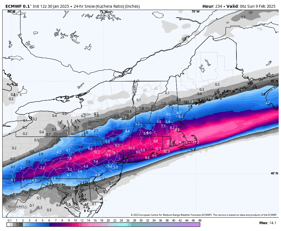
0z Euro shows this potential for the 11th. -
0z Euro shows this for the 11th.
-
Central PA Winter 2024/2025
Blizzard of 93 replied to Voyager's topic in Upstate New York/Pennsylvania
I like it, usually that means the good precip is nearby. We won’t win them all, but I think we score a couple more decent Wintry events. -
Central PA Winter 2024/2025
Blizzard of 93 replied to Voyager's topic in Upstate New York/Pennsylvania
Please, please bring me this Euro Winter storm potential for the day before the Super Bowl! The tracking alone would calm my nerves & be a great distraction up until game day.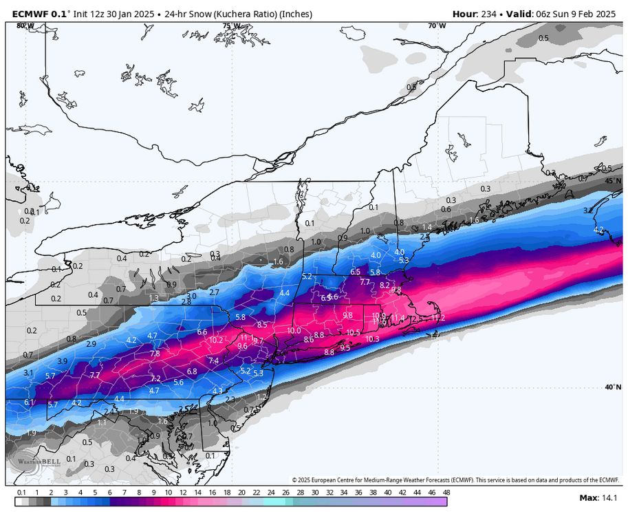
-
Central PA Winter 2024/2025
Blizzard of 93 replied to Voyager's topic in Upstate New York/Pennsylvania
Remember, I’m now on team drought… Hopefully, it is dented in February & March with several rounds of moderate to heavy snow! -
Central PA Winter 2024/2025
Blizzard of 93 replied to Voyager's topic in Upstate New York/Pennsylvania
The general theme seems to be about 1 more week of relax/moderation, before the back & forth boundary pattern gets underway later next week into the following week. Hopefully we can key in on a specific potential over the next few days. -
Central PA Winter 2024/2025
Blizzard of 93 replied to Voyager's topic in Upstate New York/Pennsylvania
6z GFS still like the 6th for a Mix opportunity, but keeps the chance a few days later to our south this run. -
Central PA Winter 2024/2025
Blizzard of 93 replied to Voyager's topic in Upstate New York/Pennsylvania
0z Euro & Canadian showed Winter storm potential on the 8th. -
Central PA Banter (Banter Less?) Thread
Blizzard of 93 replied to Itstrainingtime's topic in Upstate New York/Pennsylvania
Absolutely a terrible tragedy. It doesn’t sound like anyone made it unfortunately. -
Central PA Winter 2024/2025
Blizzard of 93 replied to Voyager's topic in Upstate New York/Pennsylvania
Way out on the 11th, the GFS shows a snow chance this run. -
Central PA Winter 2024/2025
Blizzard of 93 replied to Voyager's topic in Upstate New York/Pennsylvania
This run, the 18z GFS has any icy mix potential on the night of the 5th into the 6th. -
Central PA Winter 2024/2025
Blizzard of 93 replied to Voyager's topic in Upstate New York/Pennsylvania
Simon what? -
Central PA Winter 2024/2025
Blizzard of 93 replied to Voyager's topic in Upstate New York/Pennsylvania
I’ve had enough of this wind!