Blizzard of 93
-
Posts
13,024 -
Joined
-
Last visited
Content Type
Profiles
Blogs
Forums
American Weather
Media Demo
Store
Gallery
Everything posted by Blizzard of 93
-
Central PA Winter 2024/2025
Blizzard of 93 replied to Voyager's topic in Upstate New York/Pennsylvania
12z RGEM likes the coating idea for the LSV tonight -
Central PA Winter 2024/2025
Blizzard of 93 replied to Voyager's topic in Upstate New York/Pennsylvania
In my observations, we typically only ever see those types of ensemble totals when there is a moderate event or two in the short term. This is a major signal. -
Central PA Banter (Banter Less?) Thread
Blizzard of 93 replied to Itstrainingtime's topic in Upstate New York/Pennsylvania
Wow, the AD & Luka NBA trade was shocking! -
Central PA Winter 2024/2025
Blizzard of 93 replied to Voyager's topic in Upstate New York/Pennsylvania
The signal is getting louder on the 0z ensembles for snow chances in the upcoming 2 weeks. Most of this snow falls in week 2, but seeing ensembles showing 8 and 10 inches at this range is VERY RARE. @mitchnick have you EVER seen the EPS show a 8 to 10 inch mean for the LSV on the 15 day map unless we were staring down a major event in the short term? Me personally, I’ve never seen the EPS show 10 inches for MDT at this range for the 15 day period. No guarantees & we can’t shovel potential…. but my goodness this has the chance to be a memorable upcoming period. -
Central PA Winter 2024/2025
Blizzard of 93 replied to Voyager's topic in Upstate New York/Pennsylvania
0z GFS run of the year is under way so far with multiple opportunities over the next 2 weeks. This is just through 300 hours -
Let’s not hold back, how about the Kuchera GFS map.
-
Beyond epic run, if even close to half of it happens, most of us would be thrilled.
-
It’s more like round 4 for Wintry chances this run…
-
Central PA Winter 2024/2025
Blizzard of 93 replied to Voyager's topic in Upstate New York/Pennsylvania
I like seeing the signal for snow over the next 2 weeks on the GEFS & EPS. From my observations over the years, it’s usually a good indicator for snow potential when the 6 inch snow line reaches at least part of the LSV for the 15 or 16 day ensemble period. The vast majority of the snow is in week 2 on both ensembles. -
Central PA Winter 2024/2025
Blizzard of 93 replied to Voyager's topic in Upstate New York/Pennsylvania
12z Euro has less snow & more mix to rain this run with most of the systems tracking to our northwest this run. -
Central PA Winter 2024/2025
Blizzard of 93 replied to Voyager's topic in Upstate New York/Pennsylvania
12z GFS & Canadian continue the theme of multiple chances along the boundary over the next 2 weeks. Hopefully we are on the Wintry side for a few of them. -
Central PA Winter 2024/2025
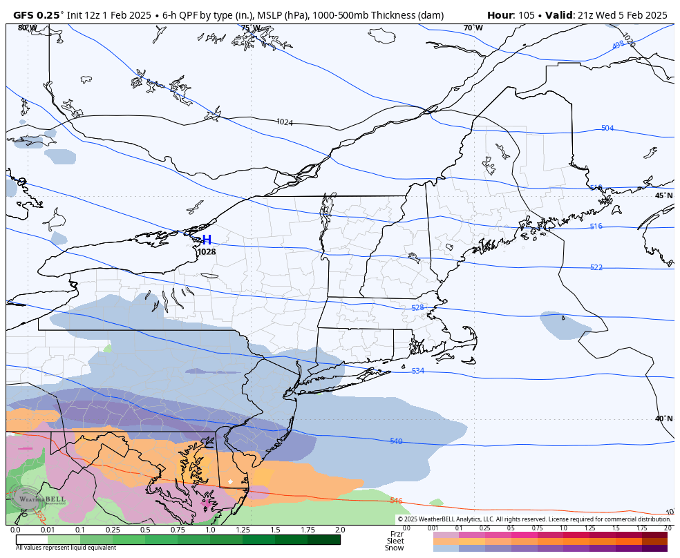
Blizzard of 93 replied to Voyager's topic in Upstate New York/Pennsylvania
Yes snow on 2/5 for the LSV, then a mix on 2/6.
-
Central PA Winter 2024/2025
Blizzard of 93 replied to Voyager's topic in Upstate New York/Pennsylvania
6z Euro AI is also full of multiple potential Winter opportunities over the next 2 weeks. -
Central PA Winter 2024/2025
Blizzard of 93 replied to Voyager's topic in Upstate New York/Pennsylvania
Here’s the 0z Euro AI for Valentine’s Eve. -
Central PA Winter 2024/2025
Blizzard of 93 replied to Voyager's topic in Upstate New York/Pennsylvania
Lol, I went there! -
Central PA Winter 2024/2025
Blizzard of 93 replied to Voyager's topic in Upstate New York/Pennsylvania
The rest of the 0z Euro AI run looks like it was run out of my basement. Drool worth for the 11th -
Central PA Winter 2024/2025
Blizzard of 93 replied to Voyager's topic in Upstate New York/Pennsylvania
The 6z GFS has 5 different Winter Storm chances over the next 16 days. Most are snow to mix scenarios, but we would build a little glacier if this run were to verify. Too many maps (lol, yes I said it) to post each individual threat. Here is the 16 day snow map just to give a general idea of the potential this run. -
Central PA Winter 2024/2025
Blizzard of 93 replied to Voyager's topic in Upstate New York/Pennsylvania
@mitchnick and others that love snow chances… The 0z EPS snow map might have had the best run of the season without a specific threat on our doorstep. Talk about potential…this is the 10 day EPS snow map from the 5th through the 15th. -
Central PA Winter 2024/2025
Blizzard of 93 replied to Voyager's topic in Upstate New York/Pennsylvania
The 0z GFS & Euro both have several Winter weather opportunities as we ride the boundary during the next 2 weeks. Some snow, some mix, some rain, it should be an interesting period upcoming to say the least. -
Central PA Banter (Banter Less?) Thread
Blizzard of 93 replied to Itstrainingtime's topic in Upstate New York/Pennsylvania
What a catastrophe! -
Central PA Winter 2024/2025
Blizzard of 93 replied to Voyager's topic in Upstate New York/Pennsylvania
2 more chances after what you posted on the super happy Happy Hour GFS. Wow, what a run! We will be in good shape even if just a couple of these hit! -
Central PA Winter 2024/2025
Blizzard of 93 replied to Voyager's topic in Upstate New York/Pennsylvania
Here is the 0z EPS look for week 2. Temps are near to slightly below normal during this time. The EPS snow map for just week 2 is ramping up amounts for this period. -
Here is the 0z EPS look for week 2. Temps are near to slightly below normal during this time. The EPS snow map for just week 2 is ramping up amounts for this period.
-
Central PA Winter 2024/2025
Blizzard of 93 replied to Voyager's topic in Upstate New York/Pennsylvania
Before that, It also has a mixed precip chance early on the 9th. -
Central PA Winter 2024/2025
Blizzard of 93 replied to Voyager's topic in Upstate New York/Pennsylvania
0z Euro shows this potential for the 11th.