Blizzard of 93
-
Posts
13,045 -
Joined
-
Last visited
Content Type
Profiles
Blogs
Forums
American Weather
Media Demo
Store
Gallery
Everything posted by Blizzard of 93
-
Central PA Winter 2024/2025
Blizzard of 93 replied to Voyager's topic in Upstate New York/Pennsylvania
The Euro is starting to adjust. Major move at 12z today vs. 0z last night. 12z top 0z bottom -
Central PA Winter 2024/2025
Blizzard of 93 replied to Voyager's topic in Upstate New York/Pennsylvania
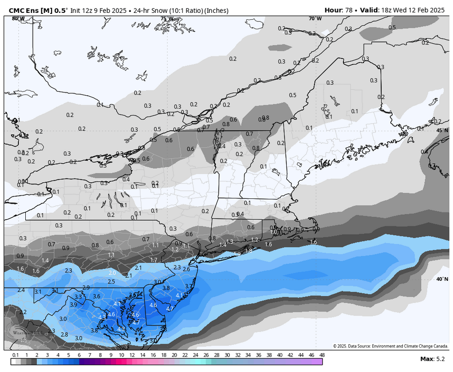
The GFS & Canadian disagree -
Central PA Winter 2024/2025
Blizzard of 93 replied to Voyager's topic in Upstate New York/Pennsylvania
12z GEFS & GEPS through Wednesday am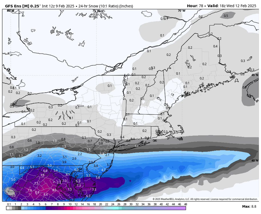
-
Central PA Winter 2024/2025
Blizzard of 93 replied to Voyager's topic in Upstate New York/Pennsylvania
Here are the total snow GFS & Canadian through Next Monday am. -
Central PA Winter 2024/2025
Blizzard of 93 replied to Voyager's topic in Upstate New York/Pennsylvania
The GFS & Canadian are looking very interesting for next weekend. It’s just a matter of time for our flush hit. -
Central PA Winter 2024/2025
Blizzard of 93 replied to Voyager's topic in Upstate New York/Pennsylvania
RGEM likes 3 to 6 for the LSV by Wednesday am -
Central PA Winter 2024/2025
Blizzard of 93 replied to Voyager's topic in Upstate New York/Pennsylvania
It looks really juicy for next weekend. -
Central PA Winter 2024/2025
Blizzard of 93 replied to Voyager's topic in Upstate New York/Pennsylvania
6z EPS ticked slightly better for the LSV for Tues/Wed.
-
Central PA Winter 2024/2025
Blizzard of 93 replied to Voyager's topic in Upstate New York/Pennsylvania
Next weekend, the GFS & Canadian are ramping up the possibility of an at least moderate snow event turning to mix in the southern tier with their latest runs. -
Central PA Winter 2024/2025
Blizzard of 93 replied to Voyager's topic in Upstate New York/Pennsylvania
The 6z GFS improved for the follow up wave Wednesday night into Thursday for the Susquehanna Valley for some front end snow before the mix. -
Central PA Winter 2024/2025
Blizzard of 93 replied to Voyager's topic in Upstate New York/Pennsylvania
6z Euro was similar to 0z with bringing Advisory level snow to the LSV by Wednesday am. Certainly room for some upside with just a slight bump north over the next 3 days until game time begins on Tuesday. -
Central PA Winter 2024/2025
Blizzard of 93 replied to Voyager's topic in Upstate New York/Pennsylvania
It really doesn’t matter much, but I just want them to get it right. We had hours of heavy sleet that needed plowed here in Marysville. Heck, even @canderson said he had 1.5” of sleet in the heat island of downtown Harrisburg. Somehow MDT gets .1 … I don’t buy it for one second! -
Central PA Winter 2024/2025
Blizzard of 93 replied to Voyager's topic in Upstate New York/Pennsylvania
@CASH_COOP It might be time for you to yet again talk to CTP… How the heck did they only record .1 of “snow” yesterday after several hours of sleet? They had several hours as “freezing rain/ice pellets” that should have added up to at least several tenths of what goes in the books as snow. Many of us not far away from MDT had near 1 inch of sleet or more… -
Central PA Winter 2024/2025
Blizzard of 93 replied to Voyager's topic in Upstate New York/Pennsylvania
The 0z Euro overall precip shield ticked north over its 18z run. The light blue is a little further north in northern PA this run. Get in the main shield & turn it will come down to banding. We have time in the LSV to get back to low end Warning amounts in the LSV. If not, I could live with 3 or 4 inches of snow this time. -
Central PA Winter 2024/2025
Blizzard of 93 replied to Voyager's topic in Upstate New York/Pennsylvania
The event is more Tuesday night into early Wednesday. They don’t post snow amounts this far out. -
Central PA Winter 2024/2025
Blizzard of 93 replied to Voyager's topic in Upstate New York/Pennsylvania
0z GEFS improved a bit as well.
-
Central PA Winter 2024/2025
Blizzard of 93 replied to Voyager's topic in Upstate New York/Pennsylvania
I think we might see more little bumps north before game time. -
Central PA Winter 2024/2025
Blizzard of 93 replied to Voyager's topic in Upstate New York/Pennsylvania
0z Canadian improved too 0z top 12z bottom -
Central PA Winter 2024/2025
Blizzard of 93 replied to Voyager's topic in Upstate New York/Pennsylvania
Yes indeed 0z top 18z bottom
-
Central PA Winter 2024/2025
Blizzard of 93 replied to Voyager's topic in Upstate New York/Pennsylvania
0z RGEM is on board for Tues/Wed -
Central PA Winter 2024/2025
Blizzard of 93 replied to Voyager's topic in Upstate New York/Pennsylvania
1.2” sleet so far in Marysville as of 10 pm & still steady sleet now. It’s been 4 years since I have seen measurable sleet like this event. -
Central PA Winter 2024/2025
Blizzard of 93 replied to Voyager's topic in Upstate New York/Pennsylvania
-
February 11-12; 12-13: Are they real??
Blizzard of 93 replied to stormtracker's topic in Mid Atlantic

-
Central PA Winter 2024/2025
Blizzard of 93 replied to Voyager's topic in Upstate New York/Pennsylvania
A little over 1 inch here. Plows just went by! plows down -
Central PA Winter 2024/2025
Blizzard of 93 replied to Voyager's topic in Upstate New York/Pennsylvania
I have nearly 1.0” of sleet now.