Blizzard of 93
-
Posts
13,023 -
Joined
-
Last visited
Content Type
Profiles
Blogs
Forums
American Weather
Media Demo
Store
Gallery
Everything posted by Blizzard of 93
-
Central PA Winter 2024/2025
Blizzard of 93 replied to Voyager's topic in Upstate New York/Pennsylvania
Most of CTP gets the snow goods with a round 2 thump. Much weaker low in the OH Valley -
Central PA Winter 2024/2025
Blizzard of 93 replied to Voyager's topic in Upstate New York/Pennsylvania
12z GFS -
Central PA Winter 2024/2025
Blizzard of 93 replied to Voyager's topic in Upstate New York/Pennsylvania
Here is the round 2 snow on the NAM. It still does this with taking a 997 low to Detroit. Hopefully future runs it weakens the low like the GFS has been doing & that might enhance front end snow. -
Central PA Winter 2024/2025
Blizzard of 93 replied to Voyager's topic in Upstate New York/Pennsylvania
We need to come in quickly for more front end snow. Hopefully the rest of 12z shows it too. -
Central PA Winter 2024/2025
Blizzard of 93 replied to Voyager's topic in Upstate New York/Pennsylvania
3k NAM juiced up too. -
Central PA Winter 2024/2025
Blizzard of 93 replied to Voyager's topic in Upstate New York/Pennsylvania
-
Central PA Winter 2024/2025
Blizzard of 93 replied to Voyager's topic in Upstate New York/Pennsylvania
Get well soon! I’m off for victory Monday, so I’ll be around today on here. -
Central PA Banter (Banter Less?) Thread
Blizzard of 93 replied to Itstrainingtime's topic in Upstate New York/Pennsylvania
I’m so so happy! Plus storms & rumors of storms this week & next…!!! -
Super Bowl Champions!!! I’m so happy!!!
-
Central PA Banter (Banter Less?) Thread
Blizzard of 93 replied to Itstrainingtime's topic in Upstate New York/Pennsylvania
Super Bowl Champions!!! I’m so happy!!! -
Central PA Winter 2024/2025
Blizzard of 93 replied to Voyager's topic in Upstate New York/Pennsylvania
Sign here for NAM -
Central PA Winter 2024/2025
Blizzard of 93 replied to Voyager's topic in Upstate New York/Pennsylvania
-
Central PA Winter 2024/2025
Blizzard of 93 replied to Voyager's topic in Upstate New York/Pennsylvania
Bring it! Hopefully the this means a good NAM & GFS. -
Central PA Banter (Banter Less?) Thread
Blizzard of 93 replied to Itstrainingtime's topic in Upstate New York/Pennsylvania
What a half…! Long way to go… Protect the ball…. Run the ball… Long way to go… -
Central PA Banter (Banter Less?) Thread
Blizzard of 93 replied to Itstrainingtime's topic in Upstate New York/Pennsylvania
LFG!!!! Long way to go … -
Central PA Winter 2024/2025
Blizzard of 93 replied to Voyager's topic in Upstate New York/Pennsylvania
It’s only a matter of time until we get a flush hit. -
Central PA Winter 2024/2025
Blizzard of 93 replied to Voyager's topic in Upstate New York/Pennsylvania
Don’t worry, we will win this weekend & next week. -
Yes!!!!!!!
-
Central PA Winter 2024/2025
Blizzard of 93 replied to Voyager's topic in Upstate New York/Pennsylvania
lol, still time for a little bump north… Not complaining about 3 to 5 either… -
Central PA Winter 2024/2025
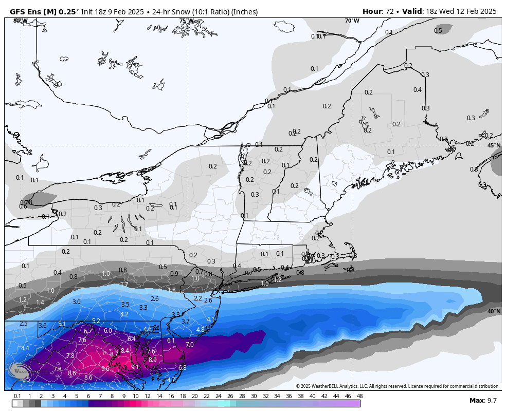
Blizzard of 93 replied to Voyager's topic in Upstate New York/Pennsylvania
18z GEFS through Wednesday am
-
Central PA Banter (Banter Less?) Thread
Blizzard of 93 replied to Itstrainingtime's topic in Upstate New York/Pennsylvania
Go Birds !!!!!! -
Central PA Winter 2024/2025
Blizzard of 93 replied to Voyager's topic in Upstate New York/Pennsylvania
I forgot it’s Wednesday already…. Come on man ! -
Central PA Winter 2024/2025
Blizzard of 93 replied to Voyager's topic in Upstate New York/Pennsylvania
RGEM -
Central PA Winter 2024/2025
Blizzard of 93 replied to Voyager's topic in Upstate New York/Pennsylvania
Here’s another NAM view -
Central PA Winter 2024/2025
Blizzard of 93 replied to Voyager's topic in Upstate New York/Pennsylvania
Where do I sign?!