Blizzard of 93
-
Posts
12,832 -
Joined
-
Last visited
Content Type
Profiles
Blogs
Forums
American Weather
Media Demo
Store
Gallery
Everything posted by Blizzard of 93
-
Central PA Winter 25/26 Discussion and Obs
Blizzard of 93 replied to MAG5035's topic in Upstate New York/Pennsylvania
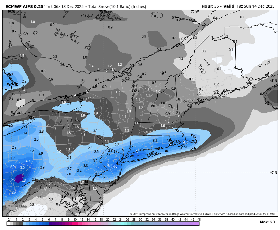
12z National Blend of Models has its best look yet especially back towards the Harrisburg area with almost 3 inches back there now.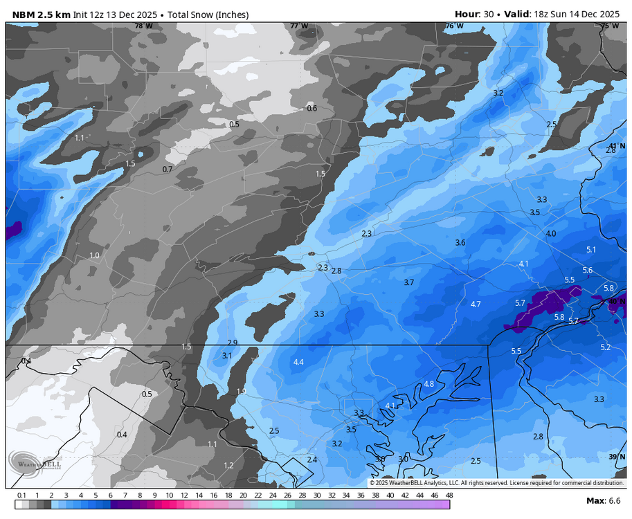
-
Central PA Winter 25/26 Discussion and Obs
Blizzard of 93 replied to MAG5035's topic in Upstate New York/Pennsylvania
You have 10:1 Chris posted Kuchera which will factor in the helpful ratios in this scenario. -
Central PA Winter 25/26 Discussion and Obs
Blizzard of 93 replied to MAG5035's topic in Upstate New York/Pennsylvania
6z RGEM & 6z Euro AI remain consistent. 6z Euro AI improved for the Harrisburg area.
-
Central PA Winter 25/26 Discussion and Obs
Blizzard of 93 replied to MAG5035's topic in Upstate New York/Pennsylvania
Very nice! Let’s goooo! -
Central PA Winter 25/26 Discussion and Obs
Blizzard of 93 replied to MAG5035's topic in Upstate New York/Pennsylvania
The 0z Euro & GFS still are advertising potential chances near Christmas. -
-
Central PA Winter 25/26 Discussion and Obs
Blizzard of 93 replied to MAG5035's topic in Upstate New York/Pennsylvania
Winter Weather Advisory URGENT - WINTER WEATHER MESSAGE National Weather Service State College PA 1114 PM EST Fri Dec 12 2025 PAZ065-066-131700- /O.EXB.KCTP.WW.Y.0025.251214T0000Z-251214T1800Z/ York-Lancaster- Including the cities of Lancaster and York 1114 PM EST Fri Dec 12 2025 ...WINTER WEATHER ADVISORY IN EFFECT FROM 7 PM SATURDAY TO 1 PM EST SUNDAY... * WHAT...Snow expected. Total snow accumulations between 2 and 3 inches. Locally higher spot amounts are possible. * WHERE...Lancaster and York Counties. * WHEN...From 7 PM Saturday to 1 PM EST Sunday. * IMPACTS...Plan on slippery road conditions. The hazardous conditions could impact the Monday morning commute. -
Central PA Winter 25/26 Discussion and Obs
Blizzard of 93 replied to MAG5035's topic in Upstate New York/Pennsylvania
All dreaming aside, we will warm up this week, but the pattern reshuffle will keep Canada cold. The core of the warm up will be in the Midwest & South. The northeast should still be able to occasionally tap into some of the available Canadian cold. With well timed Highs nosing in from eastern Canada, we could still have Winter weather chances once we head into Christmas week. -
Central PA Winter 25/26 Discussion and Obs
Blizzard of 93 replied to MAG5035's topic in Upstate New York/Pennsylvania
Meanwhile, the 18z GFS allows us to dream a little dream by showing a snow chance on Christmas Day! My dream has always been to watch the kids open their presents enjoy a nice holiday feast & then let it snow in the late afternoon through Christmas night. The GFS just showed exactly that scenario… which I will enjoy for a few hours, lol. -
Central PA Winter 25/26 Discussion and Obs
Blizzard of 93 replied to MAG5035's topic in Upstate New York/Pennsylvania
I still like my call of 1 to 3 for the LSV with a few lucky spots in York or Lancaster getting 4. The lower amounts of the range are likely to be north & west of Harrisburg. The higher end of the range is favored towards eastern York & Lanco. I think MDT has a decent chance of getting 2 inches. The RGEM & the Euro AI have been consistent the last couple of days & most closely resemble my current thoughts on this event. -
Central PA Winter 25/26 Discussion and Obs
Blizzard of 93 replied to MAG5035's topic in Upstate New York/Pennsylvania
The 6z RGEM brings a widespread 1 to 3 to 3 to the LSV. -
Central PA Winter 25/26 Discussion and Obs
Blizzard of 93 replied to MAG5035's topic in Upstate New York/Pennsylvania
CTP point & click for Harrisburg: Saturday Night Snow showers. Low around 24. Northwest wind 3 to 6 mph. Chance of precipitation is 80%. New snow accumulation of 1 to 2 inches possible. -
Central PA Winter 25/26 Discussion and Obs
Blizzard of 93 replied to MAG5035's topic in Upstate New York/Pennsylvania
0z NAM brings 2 to 3 inches for most of the LSV on Sunday am. -
Central PA Winter 25/26 Discussion and Obs
Blizzard of 93 replied to MAG5035's topic in Upstate New York/Pennsylvania
The 30 day temperature anomaly on today’s Euro Weeklies is near normal for the period from late December into late January for this region. Hopefully we have chances for Winter storms with near normal being good enough in January.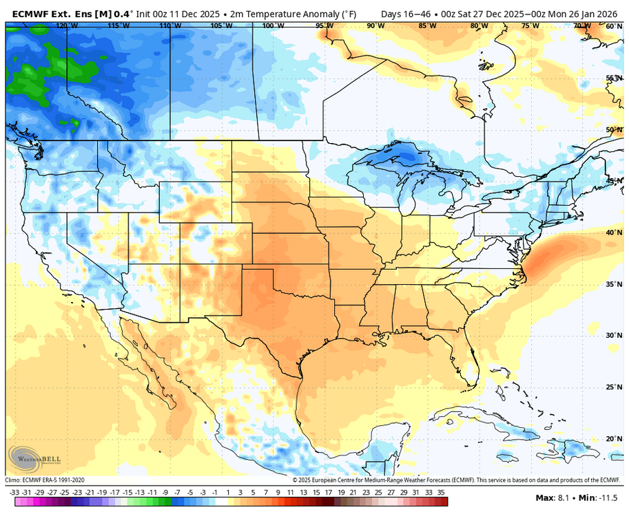
-
The 30 day temperature anomaly on today’s Euro Weeklies is near normal for the period from late December into late January for this region. Hopefully we have chances for Winter storms with near normal being good enough in January.
-
Central PA Winter 25/26 Discussion and Obs
Blizzard of 93 replied to MAG5035's topic in Upstate New York/Pennsylvania
Agreed & there is still plenty of model variability at this range. I like our chances for a solid Advisory level 1 to 3 inch snow chance with a few lucky spots getting 4 inches. Ratios should be favorable to max out whatever amount of precip we can get. -
Central PA Winter 25/26 Discussion and Obs
Blizzard of 93 replied to MAG5035's topic in Upstate New York/Pennsylvania
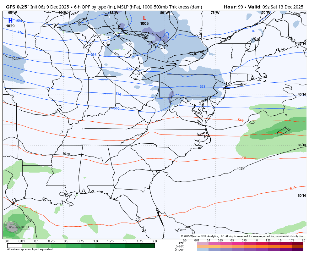
CTP thoughts on our weekend snow chance. To the south of the main upper low center near Lake Superior, another fast moving system will streak around the southern periphery of the upper trough from the Northern Plains through the Ohio Valley and into the Central Appalachians and Mid Atlantic Saturday night through Sunday morning. The upper trough is fcst to dig/amplify as it pivots eastward and should drive coastal low development while dragging a pocket of -20C air at 850mb into southwest PA/WV by Sunday afternoon. Odds are rising for a broad area of expanding/accumulating snow Saturday night through early Sunday across CPA. NBM probs for >3" are highest over the southern Laurels and southeast portion of the Lower Susquehanna Valley. The arrival of arctic air ensures snow character will be very dry and fluffy. -
Central PA Winter 25/26 Discussion and Obs
Blizzard of 93 replied to MAG5035's topic in Upstate New York/Pennsylvania
6z Euro still looks good for 1 to 3 inches snow chance on Sunday am for the LSV. -
Central PA Winter 25/26 Discussion and Obs
Blizzard of 93 replied to MAG5035's topic in Upstate New York/Pennsylvania
Good 18z Euro run for the LSV for the early Sunday chance. -
Central PA Winter 25/26 Discussion and Obs
Blizzard of 93 replied to MAG5035's topic in Upstate New York/Pennsylvania
6z Euro is looking good for the late Saturday night into Sunday chance of an Advisory type of potential. -
Central PA Winter 25/26 Discussion and Obs
Blizzard of 93 replied to MAG5035's topic in Upstate New York/Pennsylvania
18z Euro keeps us in the game for the late Saturday night into Sunday chance. -
Central PA Winter 25/26 Discussion and Obs
Blizzard of 93 replied to MAG5035's topic in Upstate New York/Pennsylvania
Yes, I noticed on my way across the bridge this morning. Super early for sure. -
Central PA Winter 25/26 Discussion and Obs
Blizzard of 93 replied to MAG5035's topic in Upstate New York/Pennsylvania
6z GFS & Euro both bring 3 to 4 inches of snow to the LSV by Sunday morning. -
Central PA Winter 25/26 Discussion and Obs
Blizzard of 93 replied to MAG5035's topic in Upstate New York/Pennsylvania
Then, 6z Euro & GFS both show a potential Advisory level chance late Saturday night into early Sunday. -
Central PA Winter 25/26 Discussion and Obs
Blizzard of 93 replied to MAG5035's topic in Upstate New York/Pennsylvania
6z Euro & GFS both give us a little light snow overnight Friday.